THE FAR SIDE OF THE SKY
© Christopher Earls Brennen
HALF DOME
``Tis-sa-ack and Nangas have broken the spell of peace.
Let us transform them into cliffs of granite that face
each other so that they will be forever parted.''
From the Yosemite Indian legend of Half Dome.
 | 
| |
|---|---|---|
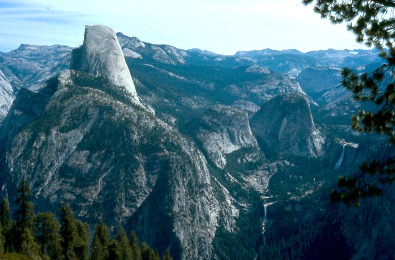
| Half Dome from Glacier Point with | Half Dome from the back | |
| Nevada and Vernal Falls on lower right |
Half Dome adorns the great valley of Yosemite like a crown jewel. Its symmetric shape and sheer polished walls are known throughout the world and people flock to this corner of California to see this and the other colossal monuments of the world's first great park. It was Abraham Lincoln who first set a marvellous precedent for the world when he signed the bill in 1864 establishing Yosemite as the nation's first state park; twenty six years later it became the first National Park. And yet this magnificence was revered even before the white man ever set foot in this land of spectacular natural beauty. The Yosemite Indians who lived on the floor of the valley must have wondered about the awesome monuments around them for they created legends to explain their existence. The legend of Half Dome tells the tale of a young married couple, Tis-as-ack and and her husband Nangas, who disturbed the peace of the valley when he abused her and she retaliated. In retribution, the gods turned them into cliffs of granite that face each other silently and forever. The husband Nangas became the Royal Arches and his wife, Tis-as-ack was transformed into Half Dome. The Yosemite pointed to the dark streaks rolling down the great face of Half Dome and said that those were the tears of Tis-as-ack as she ran from her husband.
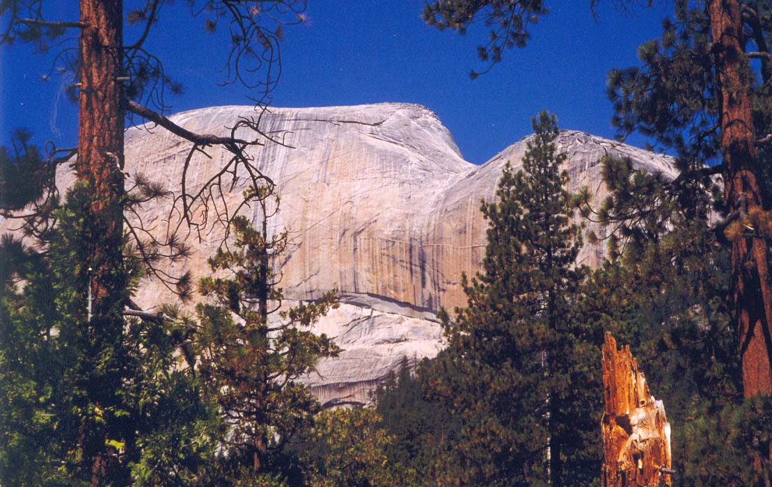
The geological story is less appealing but tells of a great rounded block of granite that was sheared in half by the glacier that formed Yosemite Valley. Today the 8836ft monolith continues to be weathered by ice that peels great slabs off the surface in a process likened to the peeling of an onion. But this occurs over geological time. Over climbers time the rock is quite stable (despite the occasional rock falls). Yosemite is perhaps the world center of big wall climbing and many of the techniques that revolutionized the sport were developed there on the awesome walls of El Capitan and Half Dome. In part this was due to the high quality of the granite; and embedded in the granite are nodules of harder rock that provided excellent natural handholds. And so today Half Dome is a favorite with big wall climbers who regularly find their way up the sheer northern face of the monument, past the tears of Tis-as-ack. The other sides of Half Dome are less steep but even they present a serious rock-climbing challenge. The easiest of these difficult routes is up the eastern shoulder where the slope is still a very steep 46 degrees. This route was first climbed by one George Anderson in 1875; then in 1919 a system of cables anchored to the rock was installed and, for the first time, allowed the summit to be attained without technical equipment. The route is still challenging and dangerous with breath-taking exposure but within the capability of the experienced hiker. I had heard of this adventure from others and set out in the summer of 1999 to experience it for myself. In order, at the same time, to sample again the marvellous high country of Yosemite, I resolved to hike from Tuolomne Meadows to the Valley, passing behind Half Dome and climbing it as a sidetrip along the way.
At 7.30am on Friday, Aug. 13, 1999, I parked my Montero in the designated hikers parking lot set back from the road a short distance east of the Curry Village in Yosemite Valley. The previous day I had obtained my backcountry permit from the Backcountry Office in Yosemite Village, and that came with a parking permit and map. The Backcountry Office also rents bearproof food cannisters at a very reasonable price and I strongly recommend renting one for reasons that will emerge.
 | 
| |
|---|---|---|
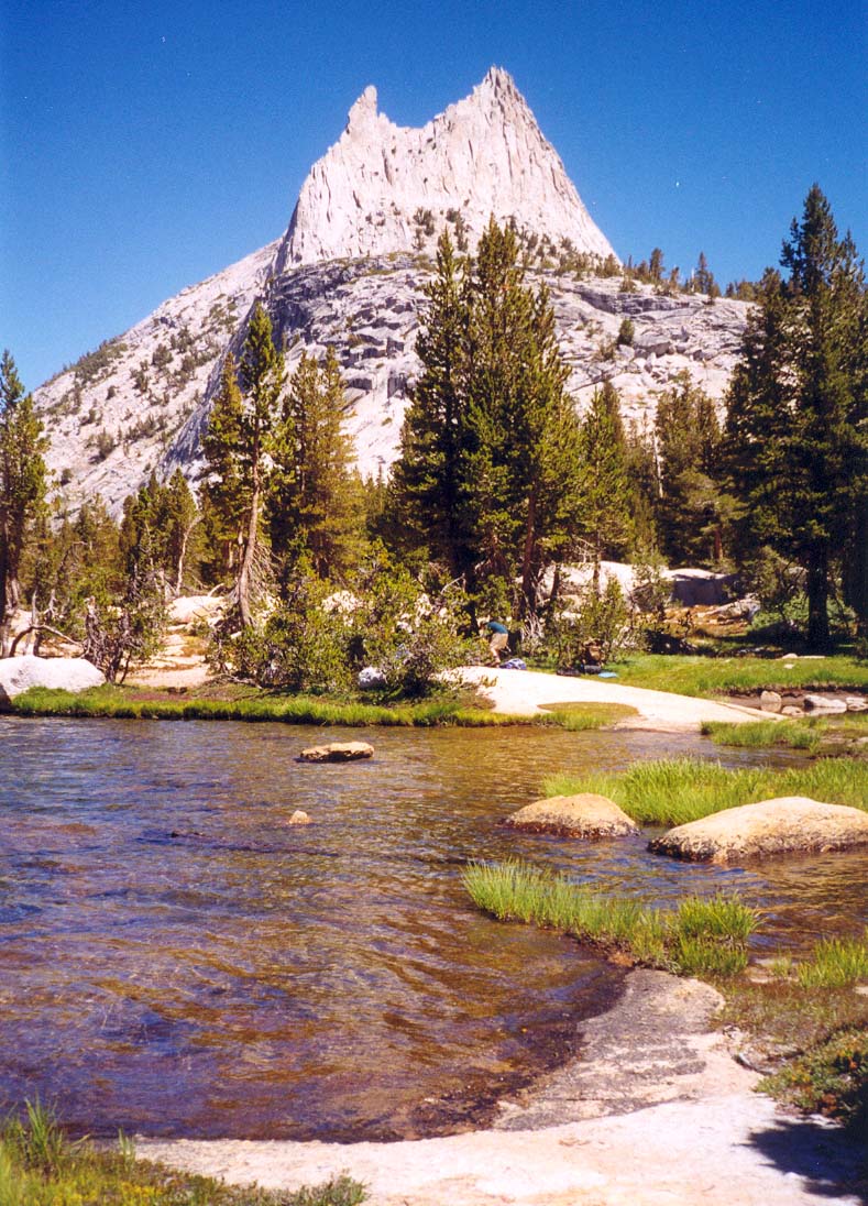
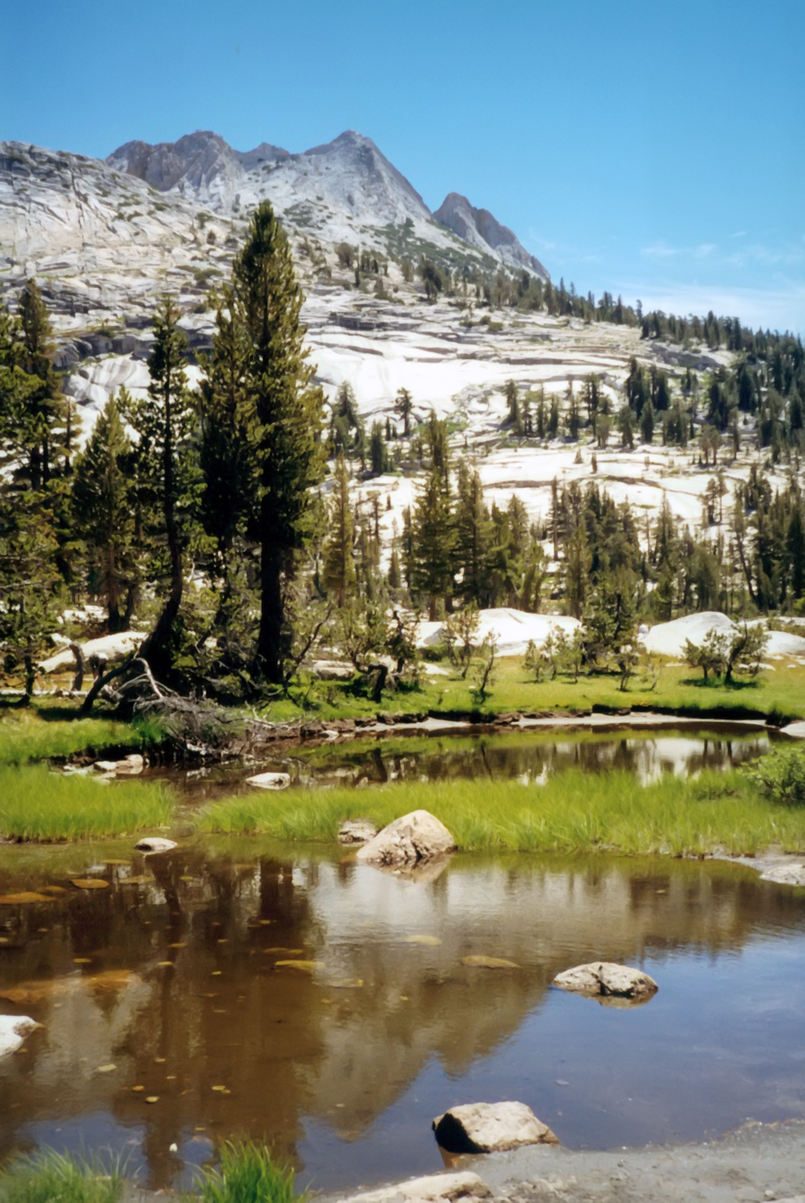
| Cathedral Lake and Peak | Near Cathedral Pass |
It promised to be another glorious, cloud-free day and a sense of excitement and adventure suffused me as I caught the shuttle bus to Yosemite Lodge. There I would connect with what is known as the hikers bus, bound for Tuolumne Meadows. I half-expected some sand-blasted old crate with open sides and backpacks piled high on the roof. Instead it was a comfortable big tour bus filled with hikers. Leaving from Yosemite Lodge every morning at 8.20am, the bus stops by request at any trailhead on the way along the Tioga Road to its terminus at Tuolumne Meadows. However, we had only travelled a few hundred yards down the valley exit road before I had reason to wonder whether Friday the 13th might be a poor day to embark on an adventure. The bus driver announced that he was feeling sick and stopped to throw up at one of the roadside toilets. Several minutes later he emerged looking only marginally better and blamed the mishap on having had breakfast at the Yosemite Lodge cafeteria. Another stop was made at the Crane Flats gas station before we set out up the Tioga Road. On this particular trip we made stops at White Wolf, Yosemite Creek, Olmsted Point and both ends of Tenaya Lake before reaching my Cathedral Lakes trailhead (just a mile or so before the terminus).
Tuolumne Meadows (elevation 8600ft) and the surrounding high country is, in my opinion, some the most beautiful country in the world. The combination of buff granite monuments, conifer forest, lush natural meadows and crystal streams, cascades and lakes creates an environment that glitters in the summer sunshine and in the winter snows. My spirit is always lifted by the sight and smell of this land and I wonder why I do not come this way more often instead of travelling to distant lands with only a pale comparison to this beauty. And so it was a sense of exhileration that I hoisted my backpack at the Cathedral Lakes trailhead (8560ft) at about 10.20am on this August morning and set off on my cross-country route to Half Dome and the Valley. From the meadows, the trail climbs gently through open conifer forest and across small alpine meadows as it rounds the western side of Cathedral Peak. Initially the view backwards includes Tuolumne Meadows but as the trail turns and rises there are some scenic views of Fairview Dome to the north. About 1hr 40min and 3.1m you come to the junction (elevation 9360ft) with the spur trail down to lower Cathedral Lake; I kept to the left along the main trail and arrived at the beautiful upper Cathedral Lake (elevation 9585ft) about 15min later. This is a truly magnificent place and a delightful lunch spot. If you have time, a circuit of the lake will provide some great mirrored views of the twin spires of Cathedral Peak (10940ft) and Eichorn Pinnacle that tower over the east shore of the lake.
Leaving Cathedral Lake, it is a short climb to the shallow Cathedral Pass (9680ft and 2hr 10min from trailhead) where you enter a very pretty flat meadow, the starting point of Echo Creek that flows south into Little Yosemite Valley. This is gentle high country and the trail contours gradually along the right side of the meadow and the lower eastern slopes of Tresidder Peak as it rises slowly above the valley. Eventually it reaches the ridge and rounds the base of Columbia Finger before rapidly descending the other side into another beautiful meadow, Long Meadow. Once in the meadow, it then meanders downstream beside the stream until, 7.1m from the start, it arrives at the marked junction with the Echo Creek trail (at 9320ft). This fork is at the head of a lower section of the aptly named Long Meadow and we take the main trail that continues along the right side of this large meadow. After travelling south for a spell, the route leaves the main stream and follows the right edge of the meadow as it turns right up into a short side branch. Just after this right turn you pass Sunrise High Camp (elevation 9280ft and 8m from start) built on the rocks a little above the meadows on the right. I reached Sunrise about 4hr 40min after setting out.
Beyond Sunrise, the trail rounds the head of this side branch of the meadow and arrives at a trail junction, the left fork being the way to Half Dome and the Valley. Beyond the fork, it climbs a short way to a saddle and crosses a stream with the last water for a few miles. There follows a long gradual climb along the side of Sunrise Mountain; eventually this culminates in a broad ridge saddle with the first spectacular views down toward the monuments of Yosemite Valley. The trail then begins a steep switchbacking descent of about 1200ft beside a small creek. At the bottom of this tough descent, it flattens out into a welcome easy stretch through dense forest. This transitions into another long flat section in a natural trough along the top of an ancient moraine and finally concludes (13.7m from start) at two trail junctions in rapid succession: the first at 8200ft is the Forsyth Trail joining from the right and the second at 7880ft is the high trail left to Merced Lake. The main route then contours into the small valley of Sunrise Creek (a fine clear stream with great drinking water) and descends first along the left bank, later crossing to the right. The proximity of the upcoming junction with the Clouds Rest trail can be judged by the increasing frequency of obvious but unofficial backpacking campsites.
I arrived at the junction with the Clouds Rest trail (7200ft and 16.4m from start) at 6.00pm, about 7hr 40min after setting out. There are many attractive campsites scattered about in the forest around this junction including a number along the banks of Sunrise Creek. I choose a very nice site atop the rocks just a few yards up and to the left of Clouds Rest trail. It had been a long day, I was weary and my feet were sore but there was adequate daylight left for the necessary tasks. I ate dinner, pumped water and then hung my food bags high above the ground from a branch of a tree about 10yds behind the campsite. I had done this effectively before and thought that the height and distance from the tree trunk were sufficient to keep my food safe from any passing bear. However, about 10.30pm, the fun began as I could overhear people below me yelling at a bear to chase the animal away from their campsites. I dozed back to sleep only to be starkly awakened at 11.15pm by the bark-tearing sounds of a bear climbing my food tree, followed by a loud crack as he (or she) broke the branch from which my bags were suspended. It took all of about 30sec for him to overcome the hurdles I had placed in his way and almost before I had awakended, he had dragged the bags a short distance into the cover of some bushes. By the time I had located my spectacles and flashlight he was already munching on his meal and I knew there was little point in trying to drive him away until he finished. There followed a long period with many sounds of tearing, licking and eating. He consumed all of my food, from Doreen's shortbread to my oatmeal, poptarts, ramen, can of baked beans (punctured by tooth or claw), plastic bottle of powdered gatorade and container of coffee. Only then did he lumber over toward my campsite looking, I guess, for another handout. When he mounted a log about 20ft from where I was lying, he finally came into full view. I flashed my light at him and yelled. He turned and left. It took me until 3.00am to get back to sleep again.
It was 7.00am before the sun reached me and motivated me to rise and dress. The first order of business was to inspect the remains of the bear's feast. At first I was mighty puzzled because I could not find anything. Then I realized that the bear had dragged my bags a short distance into some bushes. I salvaged a few items, a can opener, a carabiner and one torn bag and then cleaned up his mess as best I could. There was little left to do but pack up and be on my way - but I then discovered a packet of hot chocolate that I had failed to hang up and inadvertently left lying on the log. The hot chocolate tasted very good in the morning chill. Other than water I had but half a bottle of gatorade to last me the day. It did not seem like a major problem as my spirits rose with the warmth of the sun.
 | 
| |
|---|---|---|
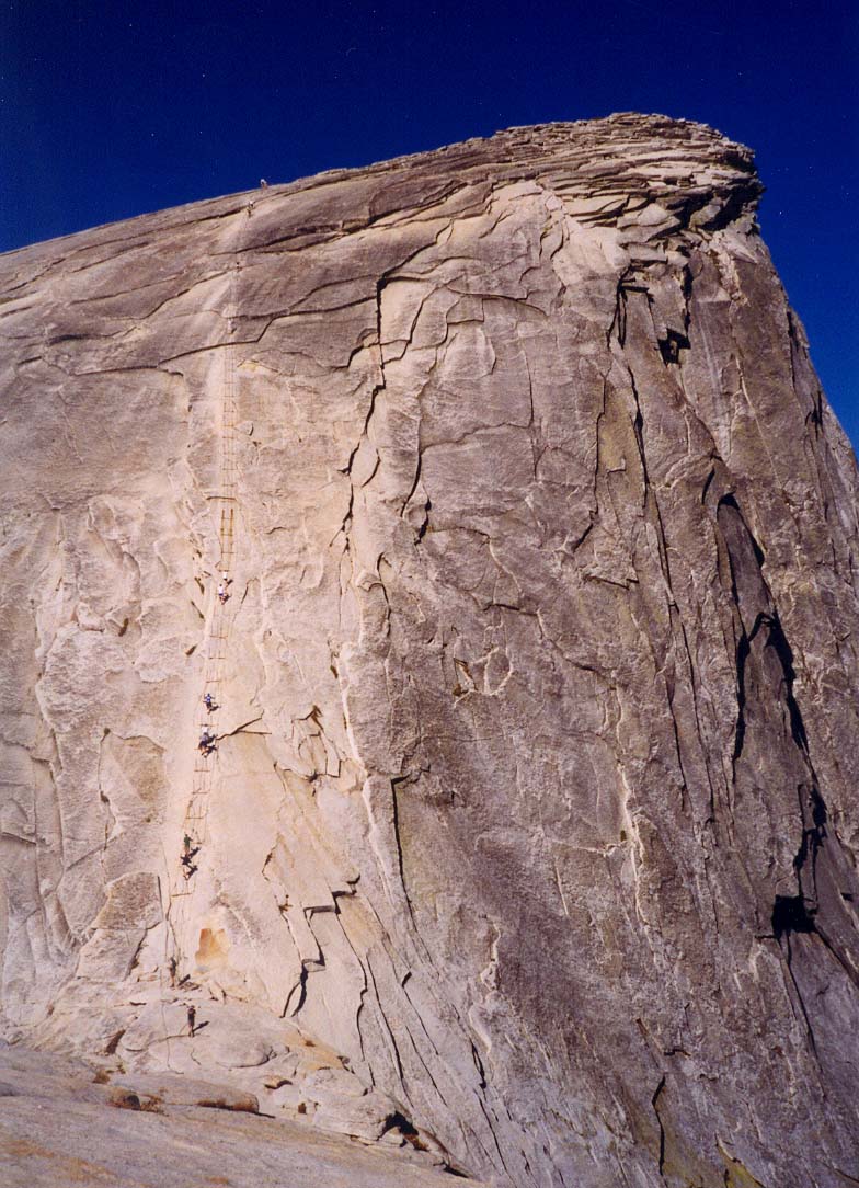
| From the Half Dome trail | Half Dome cableway |
Thus it was that I set off about 7.40am, travelling toward Half Dome of which there were increasingly spectacular views. The morning was bright and cloudless and I relished the thought of the coming adventure. After contouring along the east end of the base of Half Dome for about 0.7m, I arrived 20min later at the junction with the spur trail that led up toward the monolith. The junction at 7000ft was 17.1m from my starting point the previous day. I stowed my pack behind a log out of sight of the trail (no food left to worry about!) and carried only my waterbottle, wallet, camera and polartec jacket as I hiked up the steep trail toward Half Dome, 2.6m away. The initial climb follows a series of switchbacks up a steep wooded slope that eventually reaches an overview of Yosemite Valley and Tenaya Canyon. Then it climbs a wooded ridge, approaching Half Dome from the east. This culminates in a broad level clearing (gathering site) at the top of the wooded ridge. Here the trail makes an abrupt transition onto steep, bare rock and increased care must be taken on a number of accounts. There is not only the danger of a substantial fall but also, as the signs warn, a very real danger from lightening when storms are threatening. Large signs warn you not to proceed any further if there is any sign of an impending storm. But this was hardly a problem this morning for not a cloud could be seen in the sky.
Rock steps have been constructed on this steep rock slope and allow fairly easy though slow upward progress. Now you begin to recognize the increasing exposure and the increasing height of this switchbacking stairway. Gradually the slope lessens and you climb onto a bare rock shoulder on the east side of Half Dome. This is the shoulder that is readily visible from far below and, looking down, you recognize just how far you have climbed up the monolith.
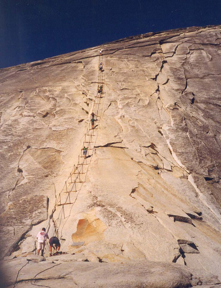
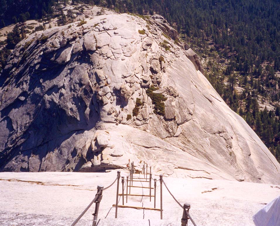
But this nothing compared with the sight directly ahead of you as you broach the shoulder. Suddenly, the most amazing sight presents itself. On the other side of a shallow saddle separating the shoulder from the summit block of Half Dome is a very steep ``trail'' straight up a seemingly smooth, vertical rock face. The summit is about 400ft up this ``trail''. It is an awe-inspiring sight both for its apparent verticality but also for its exposure and height. The ``trail'' consists of two thick steel cables about 3ft apart. At intervals, these are are anchored to bolts fixed in the rock face; they are also elevated by passing through loops on the tops of steel rod posts loosely set in holes drilled into the rock. Two-by-fours are laid across between the pairs of posts to act as steps for resting on. At the bottom lay a large pile of gloves in various states of disrepair. I was glad I had the foresight to bring my own leather gloves for few of those in the pile were intact and most were cloth rather than leather.
 | 
| |
|---|---|---|
| On the ''Diving Board'' | Looking down |
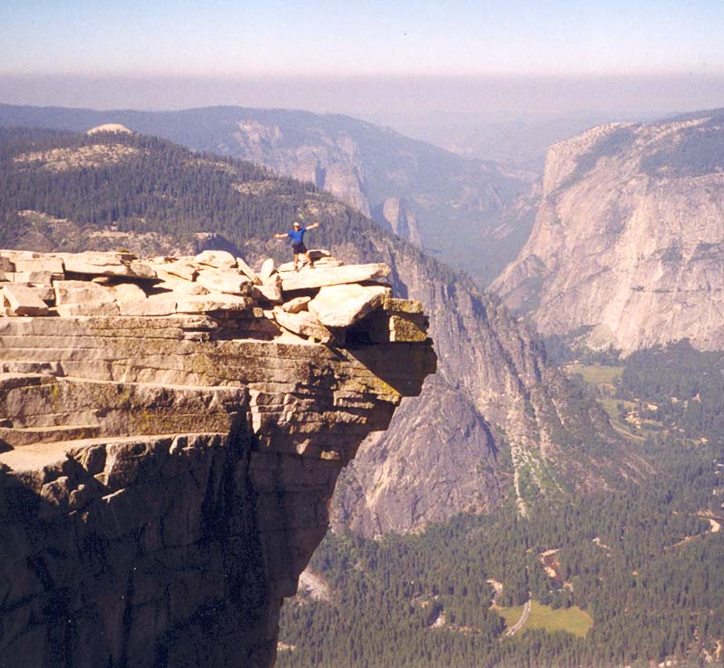
From the shoulder the vertical trail up the cable way looks exceedingly frightening and quite vertical. Many decide not to proceed and to watch their fellow hikers tremble their way to the top. In fact, the ascent is not as scary as it looks. Despite the exposure it is a fairly easy, though tiring climb. In fact the slope is only about 46 degrees. There is a short, steeper section in the middle of the ascent and there I was glad to have good soles on my hiking boots (sneakers would be much less secure). Near the top the slope eases and, all of a sudden, you are but a few yards from the 8842ft summit of Half Dome. This summit is right on the edge of the famous, vertical face you can see from the valley below and in just a few yards you can look straight down 4800ft to the floor of Yosemite Valley. It is a truly awesome view. To the west you can see the busy Yosemite Valley and the prominent profile of El Capitan. To the northeast you look up Tenaya Canyon. Even Tenaya Lake is visible in the distance. To both the north and south are breathtaking views of the rugged high country of Yosemite National Park. It all glittered in the morning sun.
I took photographs though even as I was taking them I knew none would do justice to the spectacular panoramic view before me. There is one prominent rock projection that juts out from the summit over the top of the 4800ft vertical face. Known as the ``diving board'', it makes for an awesome photograph. I was able to do a deal with another climber; we took each others photograph standing as far out on the diving board as we dared.
All too soon it was time to descend, a phase I was somewhat apprehensive about since descent is more frightening than ascent. You must look down rather than up to see where you are going. But I found it straightforward and made a rapid, face-forward descent to the shoulder in a matter of minutes. The security provided by my leather gloves and my lug-soled boots was particularly reassuring. I even paused along the way to take some pictures looking down. Behind me, the man who took my picture on the diving board was not doing so well. From the shoulder I watched him descend backwards very slowly. At one point he lost his hold on his camera. It went flying over the edge, crashing down and disappearing into Yosemite Valley. I wondered what some tourist far below would make of the mangled camera he might come across near the shores of Mirror Lake.
The rest of the descent to the main trail was uneventful; I paused along the way at a very refreshing little spring by the side of the trail. There a group of young people offered me a most welcome energy bar after hearing of my adventures the previous night. At 11.10am I reached the Half Dome trail junction (22.3m from the start), recovered my pack from behind its log and followed the steep, rocky trail down 2.2m to the floor of Little Yosemite Valley (6080ft). There I rested by the gentle and serene Merced River that winds through the floor of Little Yosemite Valley much as it later winds through the main valley. I also filled up with enough water for the rest of the day. The trail then follows the course of the Merced - first along its passive course. Then, about a mile from where it first came down to the valley floor (and at 25.7m from start), there is a sudden and precipitous drop down a dramatic cleft to the left of main course of the river. A short way down this steep descent, the spectacular Nevada Falls come into view though you can hear them before you see them. The crashing spray and thunder of the falling water reverberates the rock and generates a localised rainfall. It is a spectacular sight.
Below the base of the Nevada Falls, the trail crosses a bridge over a dramatic water chute. From there, on the left side of river, it decends past a lovely little lake, a great place for a swim. Many tourists from the valley ascend this far and so the crowds increase as you proceed downward toward the valley. Shortly you arrive at the top of Vernal Falls. The route around this obstacle is a steep staircase along the cliff wall on the left. A restroom and water fountain at the base of this descent cater to the now excessive crowds. Another bridge leads back to the right side of the canyon for the last leg down along an easy asphalt trail to the valley floor at Happy Isles (4035ft and 28.8m from the start). There I crossed a bridge to the left bank, passed the Happy Isles Shuttle Stop and hiked along the road toward Curry Village and the hiker's parking lot. It was 3.15pm when I reached the car.
As I drove back through Yosemite Village on my way home past teeming
tourist crowds, I could not help but reflect on the contrast between the
wilderness of bears and awesome rock monuments with almost imperceptible
human presence and the crowds lined up in the Village hamburger joint.
How can we possibly protect the beauty of the world in a truly
democratic way. I am not sure I know the answer to that Yosemite
dilemna; I am not even sure there is an answer.
Last updated 7/30/99.
Christopher E. Brennen