THE FAR SIDE OF THE SKY
© Christopher Earls Brennen
GRAND CANYON
``August 15, 1867. .... Early in the afternoon we discover
a stream entering from the north - a clear, beautiful creek,
coming down through a gorgeous red canyon. We land and camp
on a sand beach above its mouth, under a great, overspreading
tree with willow-shaped leaves.''
From ``Canyons of the Colorado'' by John Wesley Powell.
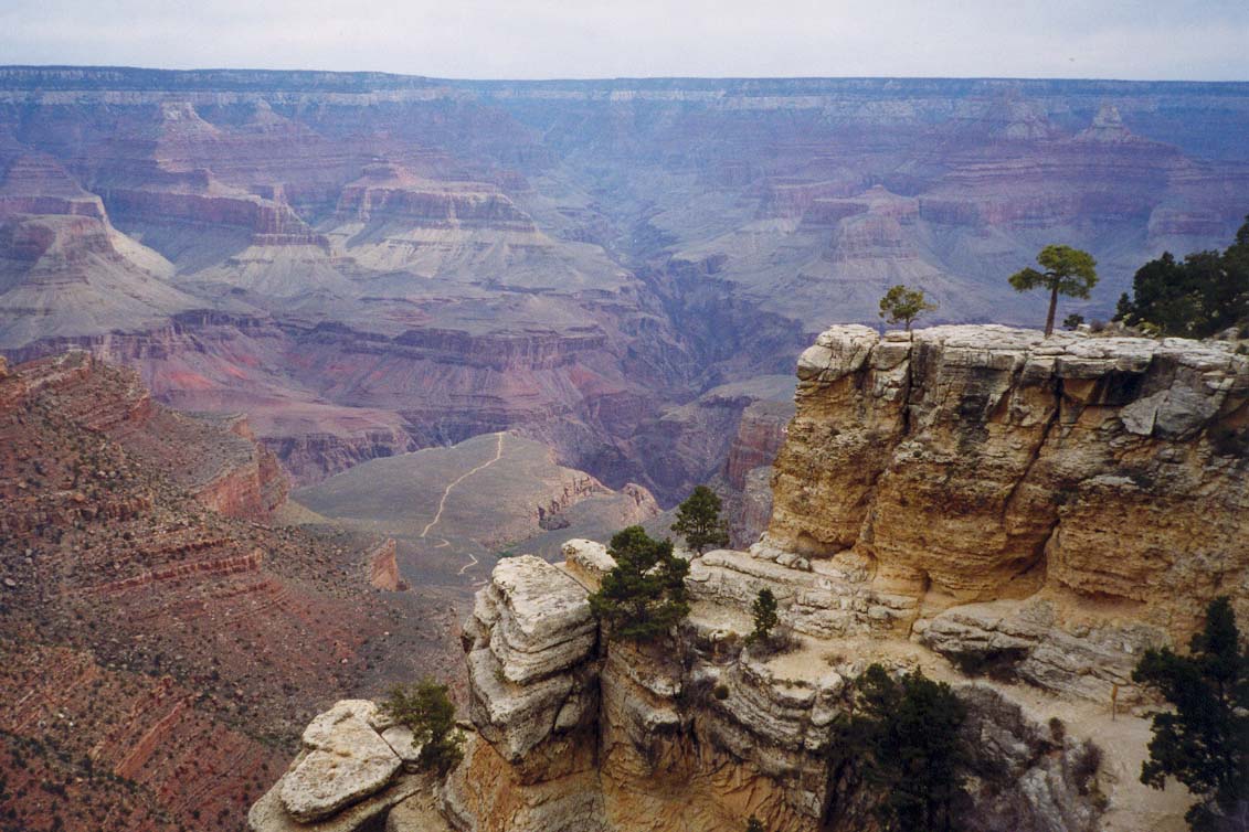
John Wesley Powell's classic account of the first passage down the Colorado River through the Grand Canyon must rank as one of the most understated adventure journals of all time. Indeed his matter-of-fact diary is perhaps the only possible literary device to use in describing the Grand Canyon for it otherwise defies description. Powell's account also initiated the legend of the Grand Canyon which spread inevitably to all corners of the globe. Today, 130 years later, people come from all those corners to see for themselves the reality of this natural wonder. Most edge their way a short distance along the rim, both amazed and overwhelmed by the immensity of the sight before them. Their brains register tilt for nothing has prepared them for this scale of deformity in the earth's surface. And they stay to watch the changing colors and shadows as their eyes roam across this magnificent canvas. Some even venture a short way down the few trails that descend the great cliffs below. But to see the canyon from Powell's perspective you must embark on an adventure yourself. Though paltry by Powell's standard, it is still to this day a significant achievement to be able to stand in the Colorado River and look up at the magnificent cliffs reaching into the sky all around you. To get there you must either (1) travel by boat down miles of fierce rapids (2) entrust your life to a mule and travel bumpily down trails with thousand foot drops just inches away or (3) hike the vertical mile down those same trails. I chose the third alternative.
In March of 1999, Clancy Rowley, Mark Duttweiler, Christine Pajak and I drove to the Grand Canyon to get to the bottom of it. It was a trip arranged at the last minute and so we had none of the required permits. After a brief but futile effort to obtain a backcountry permit that would allow us to camp at the Bright Angel Campground by the Colorado River, we decided to spend the first day hiking part of the way down the Hermit Trail. Thus we spend a pleasant day hiking down to Santa Maria Springs (elevation 4880ft) from Hermit's Rest (6640ft) and back up. We followed that with a very scenic hike along the Rim Trail from Mohave Point to Hopi Point. This prepared us physically and mentally for the next day, March 24, when we planned to hike to the Colorado River and back to the rim.
 | 
| |
|---|---|---|
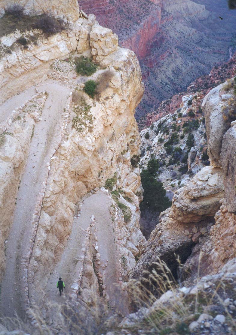
| River from the rim | Start of South Kaibab Trail |
The South Kaibab Trail was constructed by the National Park Service in 1924 to compete with the privately owned Bright Angel Trail because Ralph Cameron charged a $1 toll for the latter. All the other trails down into the Canyon were located along the easiest routes and these were virtually all beside major creeks feeding the Colorado whose watercourses had eroded substantial recesses in the canyon walls. As a consequences the views from these other trails, while still spectacular, tended to be restricted by the surrounding canyon walls. On the other hand the South Kaibab Trail was specifically constructed with tourists in mind and follows an open, lateral ridgeline rather than a lateral valley. This, in itself, makes for a spectacular trail and its views are gloriously panoramic. The builders did have to build another bridge over the Colorado at the bottom of the trail and this was a major undertaking. For this bridge, eight 550 feet long, 2320 pound steel cables, 1.5 inches in diameter, had to be carried down the almost-completed trail. This considerable feat was accomplished by 42 Havasupai Indians each of whom therefore hefted 50 pounds of cable down 6.3 miles of tortuous and precipitous trail. The cables thus crept down into the canyon like great, squirming centipedes.
Clancy and I caught the 7.15am bus to the South Kaibab Trailhead (elevation 7260ft) and went over the rim about 7.30am. The first phase descends the very steep upper wall of the canyon by means of a spectacular series of switchbacks cut into a recess in the otherwise unnegotiable cliff. At the bottom of the rim cliff you then emerge onto a talus slope and the trail contours along this slope to the apex of the South Kaibab ridge below Yaki Point. For most of the descent from this point to the Tonto Plateau, the trail follows Cedar Ridge and allows access to frequent sensational panoramas sometimes to the west, sometimes to the east. Shortly after gaining the apex of the ridge, we arrived at 8.10am at the Cedar Ridge Resthouse with its magnificient views, 1.5mi down the trail at an elevation of 6320ft. We were most fortunate; the day was crystal clear and cloudless.
 | 
| |
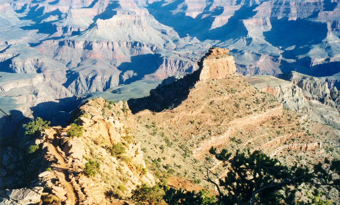
|---|---|---|
| O'Neill Butte from Cedar Ridge | South Kaibab Suspension Bridge |
Continuing on, the trail proceeds around the east side of O'Neill Butte, descends to a flat-top mesa and then drops off the end of the mesa down through a quite dramatic chute. Below this it reaches down to the Tonto Plateau where there is another resthouse at the intersection of the South Kaibab Trail and the Tonto Trail (elevation 4000ft). A few yards beyond that junction, the trail plunges off the edge of the Tonto Plateau at a place appropriately named the Tipoff, 4.4mi from the trailhead. Suddenly, dramatic and precipitous views of the Colorado open up as the trail snakes down the steep walls of the Inner Gorge toward the river. The rock changes from the red and white sandstone of the upper cliffs to the black and green colors of the Vishnu Schist. This change is called the Great Unconformity, a name that would be pretentious anywhere else but in the Grand Canyon. Finally, 6.3mi and 3hr from the rim, we arrived at 10.30am at the bottom of the Grand Canyon where the river elevation is 2480ft. Just short of the river, you encounter a trail fork; the left trail proceeds west along the precipitous south bank (cliff) of the river. We took the right fork that leads, via a tunnel, to the Kaibab or ``Black'' Suspension Bridge. Crossing the bridge we stopped at Boat Beach just downstream on the north shore. Here we lingered in the warm sun, even shed our boots and waded in the Colorado River. I would have like to swim but the water was a very cold 47 degrees (Fahrenheit) despite the air temperature in the 90s. But the river is magnificient, fast and powerful. It was hard to see how one could possibly cross it safely without some sort of boat. At last, I could stand in the Colorado and look up at what John Wesley Powell would have seen on
``August 16, 1867. We must dry our rations again today and make oars. ...... We have named one stream away above, in honor of the great chief of the ``Bad Angels,'' and as this is in beautiful contrast to that, we conclude to name it ``Bright Angel''. Early in the morning the whole party starts up to explore the Bright Angel River, with the special purpose of seeking timber from which to make oars.... The stream heads away back under a line of abrupt cliffs that terminates the plateau, and tumbles down more than 4,000 feet in the first mile or two of its course; then runs through a deep, narrow canyon until it reaches the river.''
But amazingly Powell also found the remains of human habitation. To continue the previous quotation from his diary:
''Late in the afternoon I return and go up a little gulch just above this creek, about 200 yards from camp, and discover the ruins of two or three old houses, that were originally of stone laid in mortar. Only the foundations are left, but irregular blocks, of which the houses were constructed, lie scattered about. In one room I find an old mealing-stone, deeply worn, as if it had been much used. A great deal of pottery is strewn around, and old trails, which in some places are deeply worn into the rocks, are seen. It is ever a source of wonder to us why these ancient people sought such inaccessible places for their homes. ....''
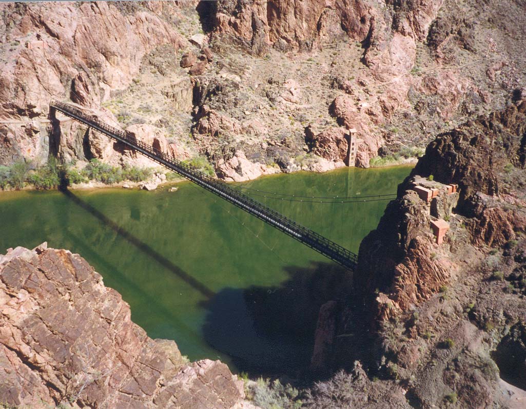
But back to the present. After our sojourn on the historic Boat Beach where Powell once camped, we resumed our hike along the north side of the river. It was but 0.4mi to Bright Angel Campground perched on a narrow strip of land along the west bank of Bright Angel Creek just above the point where it empties into the Colorado. Another 0.5mi up Bright Angel Creek brings you to Phantom Ranch, 6.9mi from the South Kaibab Trailhead. The Ranch has a number of cabins available for rent (about $63 per night in 1999) though these are booked many months in advance. It also has dormitory bunk beds at $23 per night. It is a pretty and serene little place amid the relatively luxurious foliage of Bright Angel Creek. Clancy and I stopped there in the shade while I consumed a Phantom Ranch lemonade. But, all too soon, it was time to move on. We made our way down Bright Angel Creek to the Silver Suspension Bridge over the Colorado River. Interestingly this second bridge serves another purpose besides allowing hikers to cross the river. It also carries the high pressure water pipeline that supplies the South Rim with water from a spring source to the north. This pipeline is routed through Indian Gardens where the pumping station is close to the Bright Angel Trail.
 | 
| |
|---|---|---|
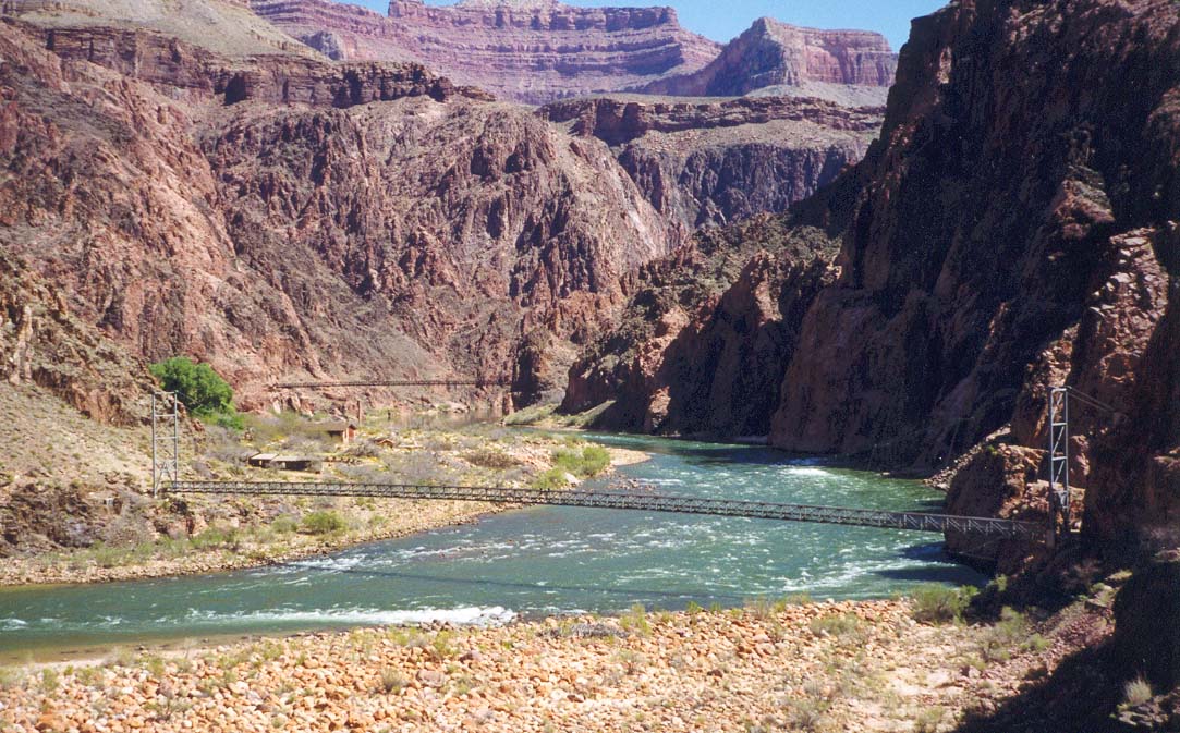
| Colorado by Bright Angel Creek | Top of Bright Angel Trail |
We crossed the Silver Suspension Bridge at 11.55am and followed the River Trail westwards along the south side of the Colorado River. This section is unpleasantly sandy until it begins climbing a steep bluff where the river makes a left turn. Turning the corner the trail descends again to the small, rocky beach where the Bright Angel Trail meets the Colorado, 2.1mi from Phantom Ranch. Here at 12.25pm we paused only briefly before entering the small narrow canyon through which the Bright Angel Trail begins its ascent.
And so we began the long climb back up to the rim along the Bright Angel Trail. The upper part of this trail was originally used by the Havasupai Indians to commute between the rim and Indian Gardens. Prospectors, looking for gold, improved the trail at the end of the last century. Then one enterprising prospector, Ralph Cameron, realizing that there was more money to be made from the tourist trade than from mining, bought out his companion's interests in the trail and set up a toll booth, charging sightseers $1 to venture down below the rim. He also extended the trail to the Colorado. It was only after a long battle with Cameron that the National Park Service took over the trail in 1928.
Leaving the River Resthouse, elevation 2400ft, the Bright Angel Trail first winds its way gently up the the pleasant canyon of Pipe Creek. After about half a mile you pass a pretty, mossy waterfall on the right wall and shortly thereafter, the trail leaves the creek bed and climbs up the steep right wall of the canyon using a series of switchbacks known as the Devil's Corkscrew. The name refers to the fact that this is usually the hottest segment of the trail with temperatures in the summer that often reach 130 degrees Fahrenheit. The black rock of the Vishnu Schist mercilessly absorbs the sun and bakes the air. Even on this March day it was close to 90 degrees. However the trail soon emerges from the Devil's Corkscrew and transitions into the next canyon through which Garden Creek runs. As we made this transition, the lovely sounds of flowing water floated down to us and soon we were soaking our heads in the water of Garden Creek under the shade of willow trees. The next section is much more pleasant as the trail winds its way up through the Tapeats Narrows, the canyon of Garden Creek, finally (at an elevation of about 3800ft) emerging from the Inner Gorge onto the Tonto Plateau. As we did so we could also see hikers on the Plateau Point trail over to our right. Soon we could also see the trees and bushes of Indian Garden and, 1hr 35min after leaving the Colorado, we arrived at that busy and attractive oasis. In the spring this is a particularly attractive rest-stop, with the vibrant purple tree flowers providing a special delight.
The focus of life at Indian Garden is, of course, the water fountain with its multiple spigots. We splayed ourselves on one of the surrounding benches and drank our fill before seeking out a picnic table to enjoy a leisurely lunch. I even took a 10min snooze atop a neighboring table in order to settle my food and prepare for the next long haul.
Above Indian Garden, the trail initially proceeds into the head of the canyon until it seems almost directly below the rim. It then begins a long series of switchbacks as it climbs the increasingly steep wall below the rim. This section is known as Jacob's Ladder and involves a long and arduous climb. There are two self-explanatory rest houses. An hour out of Indian Garden we arrived at Three-mile Resthouse (elevation 4720ft), perched on an outcropping with one of the better views from the Bright Angel Trail. Beyond Three-mile Resthouse, the trail has been cut into the cliff, the natural slope being close to vertical. One-and-a-half-mile Resthouse (elevation 5720ft) sits on a rock slope and presages the last 1000ft up a natural break in the cliff wall. The Bright Angel Trailhead comes into view at the end of a long switchback just below the rim (elevation 6860ft). The total distance from the river is 7.7 miles and we reached the rim and the Bright Angel Trailhead (6860ft) at 5.20pm, just under 5 hours after leaving the Colorado (inclusive of a 40 minute break at Indian Garden).
And so we travelled a microscopic distance in the shoes of John Wesley
Powell. It did not help me understand what drove that
almost fanatical,
one-armed adventurer for this 1999 visit was hemmed in by those constraints
necessary for managing visitors to such a popular destination. I had to
cast my mind back
to other adventures in much wilder places in order to understand
the lure, the narcotic of the unknown and the untamed. Of
solitary confrontation with physical challenge and the delicious hint
of danger. But I ask myself whether
I would have dared to challenge this gigantic place had I stood in
Powell's shoes. I doubt it very much.
Last updated 7/30/99.
Christopher E. Brennen