ADVENTURE HIKES AND CANYONEERING
IN THE SAN GABRIELS
© Christopher Earls Brennen

|
|---|

|
Hike B5. Vasquez Creek
- Hiking time: 6 hours
- Estimated hiking distance: 5 miles
- Elevation gain: 860 feet
- USGS Topo Maps: Condor Peak
- Difficulties: Some small but challenging rappels, one 60ft rappel and much wading
- Special equipment: Rappelling equipment with 120ft rope, two rappel rings and 20ft webbing
-
ACA Rating: 3A III

Characteristics
Legend has it that the famous bandit, Tiburcio Vasquez, and his gang, after a 1874 raid on a ranch in the San Gabriel valley, attempted to evade the sheriff and his posse by riding up the Arroyo Seco, up Dark Canyon to a saddle and then descending Vasquez Creek to Big Tujunga Canyon. They then rode down the Big Tujunga and escaped. However, as this adventure will demonstrate, there are some minor difficulties with this story for it is impossible to negotiate the canyon of Vasquez Creek aboard a horse due to the waterfalls that bar the way. In fact, it seems likely that Vasquez probably followed an old Indian trail that may be the same as the trail we will hike during the first part of this adventure.
This attractive, intermediate adventure hike introduces you to a canyon on the precipitous north-facing slope of Mount Lukens. Steep north-running canyons are relatively rare in the San Gabriels and the adventurer will notice several features that distinguish them. The slopes (and to a lesser degree the canyons) are more heavily wooded leading to shadier streamsides. This, in turn, leads to a different canyon foliage, in the present case to abundant ferns. These make Vasquez Canyon more like a rain-forest canyon than a desert canyon. The hike involves about five rappels, mostly in the 20ft range. These are generally close to or in the stream and so are not straightforward. However, the one large rappel (about 60ft) is dry and very enjoyable. It is inevitable that you will get very wet in this canyon and so the hike is best undertaken on a warm summer day.
Trailhead
The trailhead for this hike is the parking area at Stonyvale Picnic Area in Big Tujunga Canyon. Drive up Big Tujunga Road and turn right onto the road to Vogel Flat. At the bottom of the hill, turn left and go to the parking lot at the end of the road (at 34o17.08'N 118o13.40'W and elevation 1840ft).
Hike
The first part of this adventure is an easy hike along the canyon bottom, travelling upstream. You must cross the river in several places and therefore you should be warned that this can be difficult and dangerous at times of high water. You cross to the south side of the river just east (upstream) of the parking lot and then proceed across a broad gravel flat. Near the end of this gravel flat there is a trail fork and you should go left, recrossing the stream and soon accessing a broad, well-worn trail that generally proceeds upstream on the north side of the river. If, in error, you take the right fork at the end of the gravel flat you will be led to a much slower trail on the south side of the river; then traverse across to the trail on the north side.
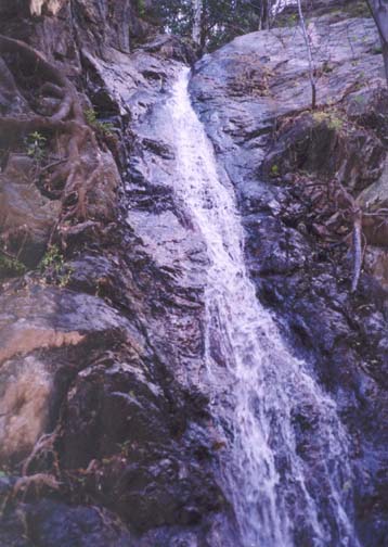
|
|---|
| Junction Falls |
As you walk, try and distinguish the large and precipitous canyons that cascade down the north slope of Mount Lukens and enter Big Tujunga on its south side. About 0.35mi from the parking lot Big Tujunga makes a big left turn (as you walk upstream) and Suicide Canyon enters in the recess formed on the south side by this turn. In a very similar manoever about 0.65mi from the start, Big Tujunga makes another big left turn and Silver Canyon enters in this recess. The trail becomes indistinct here but you should cross to the south side of the river and come to a substantial trail on a bench south of the river and just east of Silver Canyon. To reach the maintained trail to Grizzly Flat you will probably have to backtrack along this south side trail for about 100yds to find (about 30min from the trailhead) the Grizzly Flat trail immediately west of the Silver Canyon opening (at 34o16.56'N 118o12.84'W and elevation 1940ft).
Follow the Grizzly Flat trail as it climbs the ridge separating Silver Canyon and Vasquez Creek. At about 2440ft (and 1hr from the start) you arrive at a small saddle with a dramatic view into the precipitous Silver Canyon. Then the trail contours to the east into Vasquez Canyon, or more precisely an unnamed tributary that we will encounter later in this hike. Soon the pine forest on Grizzly Flat will be visible on the other side of this gully and the trail contours around the head of the gully and along to a point (elevation 2700ft) where it meets the end of the fire road that comes down to Grizzly Flat from the ridge above. The fire road leads to the Angeles Crest Highway which lies just on the other side of the ridge. You should reach Grizzly Flat about 1hr 15min from the start.
Grizzly Flat is a large plantation of fir trees on a sloping bench on the west side of Vasquez Creek. It is criss-crossed with old fire and maintenance roads that run roughly NE-SW. From the point where the trail emerges to meet the main fire-road (at 34o16.09'N 118o12.53'W), it is best to head north, following a faint use-trail along a small ridge on the western edge of the Flats. From here you should see the trail you climbed up on the other side of the unnamed gully. Shortly you will then descend along the end of this ridge onto the flatter part of the forest. Continue in a northerly direction, perhaps veering slightly to the east until you can see the steep slope on the other side of Vasquez Creek directly ahead of you. The edge of the canyon within which the Creek runs is fairly distinct and when you reach this edge you will recognize that slope between you and the stream is steep and becomes vertical some distance below you. Then you need to walk east until the canyon wall decreases in height and steepness and allows you to drop down to the stream. You should reach the drop in point (at 34o16.19'N 118o12.31'W and elevation 2440ft) about 1hr 30min into the hike.
The canyon in the vicinity of the drop in point is very narrow and progress downstream requires the negotiation of numerous small chutes and waterfalls. Soon, you will arrive at a more substantial 20ft waterfall that neccessitates a rappel using a small tree on the right as the anchor. Another 15ft rappel follows immediately and, again, there is a convenient tree growing out of the cliff on the right that provides a convenient anchor. About 30yds further and you come to the third of this series of small rappels. This is a longer chute dropping about 20ft with a number of downed trees lining its sides. The roots of one of these large trees provides an anchor.
After this upper section, the canyon broadens a little and flattens out and the going is easier for several hundred yards before you suddenly arrive at the junction of Vasquez Creek and the previously mentioned, unnamed gully (at 34o16.43'N 118o12.59'W and elevation 2210ft). Here both streams cascade down impressive waterfalls just before they merge creating an attractive and interesting junction. We called these Junction Falls. The descent along Vasquez Creek requires two rappels. The first utilizes a large tree a little upstream of the lip on the left bank of the stream and allows you to descend two small cascedes (15ft and 5ft) to the top of the main waterfall. Be warned that the small pool between the 15ft and the 5ft is, unexpectedly, chest deep though you can avoid excessive submergence by straddling the pool. Having negotiated this preliminary rappel, you arrive at the lip of the 60ft rappel. For this there are two small trees on the left that provide excellent anchors for a dry rappel down the rock face several yards to the left of the water. You should reach the bottom (elevation 2100ft) about 5hrs after you started out.
Between the bottom of Junction Falls and the point where the canyon
joins the Big Tujunga
(at 34o16.58'N 118o12.65'W), there are no
substantial obstacles and this
section can be covered in 20min. Turn left as you exit
Vasquez Creek and follow
the water (or waterbed) in the Big Tujunga for about 100yds until the
stream turns
right. The nice pool at this point makes for a relaxing rest stop.
When you resume hiking, follow the left wall of the canyon as it turns
left and you will
soon rejoin the bench from which you accessed the Grizzly Flats trail
earlier in the day. From here you retrace your steps
back to the parking lot
(34o17.08'N 118o13.40'W).
Last updated 7/30/99.
Christopher E. Brennen