ADVENTURE HIKES AND CANYONEERING
IN THE SAN GABRIELS
© Christopher Earls Brennen

|
|---|

|
Hike B16. Upper Lucas Creek
- Hiking time: 4.5 hours
- Estimated hiking distance: 4.3 miles
- Elevation gain: 1240 feet
- USGS Topo Maps: Condor Peak
- Difficulties: Steep chute downclimb, a 60ft rappel
- Special equipment: 160ft rope, harnesses, 8ft webbing and a rappel ring
-
ACA Rating: 3A II

Characteristics
Lucas Creek originates on the northwestern slopes of Strawberry Peak and travels northwest to join the Big Tujunga. This collection includes two hikes along Lucas Creek. This first hike travels from the canyon head down to the Angeles Forest Highway; a later hike continues down to the Big Tujunga.
The head of the canyon can be accessed from the ridge between Josephine and Strawberry Peak. The canyon of Lucas Creek is a moderate sized, north slope canyon, wooded and brush-free. Thus it constitutes a fairly easy and reasonably short adventure hike that only has one substantial technical obstacle, a 60ft rappel that could be bypassed if necessary. It is good hike for almost anytime of year.
Trailhead
This hike requires a car shuttle. From La Canada/Flintridge drive up the Angeles Crest Highway and turn right at the Clear Creek junction onto the Angeles Forest Highway. When you pass the junction with the Big Tujunga Canyon Road take note of the odometer and drive just over 1.0mi to where the Angeles Forest Highway crosses Lucas Creek (at 34o17.92'N 118o8.91'W and elevation 3040ft). Park one vehicle in the dirt parking area on the right and then drive back to Clear Creek junction in the other vehicle(s). Park in one of the pullouts surrounding this junction (at 34o16.22'N 118o9.19'W and elevation 3650ft).
Hike
The Josephine Fire Road begins on the east side of Angeles Forest Highway just about 50yds from the intersection at an elevation of 3650ft. Pass the metal gate and hike up this well-used dirt road as it climbs steadily toward the ridge between Josephine and Strawberry Peaks. When, after 1hr 10min and 2.6mi of hiking, you come to the ridge (34o16.95'N 118o8.52'W and elevation 4890ft) you are treated to spectacular views both to the south and the north. To the south you can see downtown Los Angeles and beyond, the Pacific Ocean, the Palos Verdes peninsula and Catalina Island. In the other direction, the northern San Gabriel mountains are spread out before you. You are looking up the valley of Mill Creek toward the saddle where the highway begins its descent toward Palmdale. To the left of that is Mount Gleason and you can see the Fall Creek/Mount Gleason fire road wind its way up the long ridge toward that summit.
|
|---|
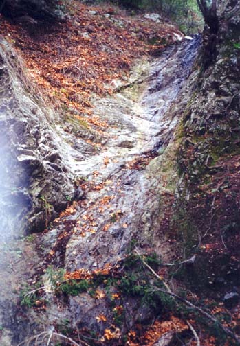
| Lucas Creek Falls |
Directly below you is the canyon of Lucas Creek that starts off to your right on the slopes of Strawberry Peak and slices west to cross the Angeles Forest Highway. You can glimpse a short stretch of that road far below you. Turn right and follow the trail eastwards along the ridge for about 0.5mi to Josephine Saddle (34o16.92'N 118o8.05'W and elevation 4850ft). You should reach this point about 1hr 20min from the start.
From Josephine Saddle you need to backtrack 150yds along the trail to find the recommended drop-in route for Lucas Creek. This consists of a steep, rugged gully with lots of sand and loose rock. The 460ft descent down this gully/scree slope is relatively easy though the danger from tumbling rocks is evident. Here it is important for only one person to descend at a time, for those below to take refuge to the side of the gully and watch for the tumbling rocks and for those above to stay still to avoid loosening rocks. You should reach the bottom of Lucas Creek canyon (elevation 4390ft) about 2hrs from the start.
Lucas Canyon itself is typical north slope canyon with a relatively easy gradient. It is wooded, brush-free and mostly open, fairly easy going over a boulder and log-strewn bottom. No use-trail is evident except very near the end. About 30min down the canyon at an elevation of 3970ft you will encounter a 20ft downclimb over bedrock. The best route here is down the center. Another 20min will bring you to an awkward 6ft waterfall that can be bypassed on the left.
Then, 3hr 10min and 3.5mi from the start at an elevation of 3670ft, you will arrive at the top of the only substantial obstacle in this hike. Here the canyon drops about 60ft down a steep and narrow waterfall. The best way to descend is to set up a rappel using one of the trees off to the right side as anchor. From there it is a 60ft rappel down to the gravel flat at the bottom. You descend to a junction with another large gully entering on the left. We note that this rappel can probably be avoided by climbing up the canyon wall on the left a short distance above the lip of the waterfall and contouring around to a large tree at the top of a steep, earthen gully that looked as though it could be downclimbed safely. The gully is in the vertex between the two merging canyons.
Proceeding downstream from the rappel, the canyon bottom is rough but still moderately easy going. Gradually, the stream develops and there are some very pretty and bucolic stretches with pools and small cascades. Near the end another large gully joins from the left and a use-trail is evident. The noise of the passing vehicles will also signal that the end is near. You should come to the Angeles Forest Highway and your return vehicle at 34o17.92'N 118o8.91'W and an elevation of 3040ft about 4hrs 30min from the start.
Last updated 1/23/01.
Christopher E. Brennen