ADVENTURE HIKES AND CANYONEERING
IN THE SAN GABRIELS
© Christopher Earls Brennen

|
|---|

|
Hike C5. Strawberry Peak
- Hiking time: 5 hours
- Estimated hiking distance: 6.0 miles
- Elevation gain: 2680 feet
- USGS Topo Maps: Condor Peak, Chilao Flat
- Difficulties: Two moderate free climbs
- Special equipment: None
-
ACA Rating: 2A III

Characteristics
The ascent of 6164ft Strawberry Peak from the Colby Canyon trailhead is a hike that appears in many hiking guides. It is included here because it is a fine hike with great views in many directions as well as a significant climbing challenge. The first half of the ascent follows the established Colby Canyon trail up to Josephine Saddle on the Josephine/Strawberry ridge. Then the off-trail portion follows this ridge to the summit of Strawberry. Though off-trail most of this route simply requires following a well-established use-trail. However, that use-trail is interrupted in two places by rockfaces that require climbing and careful route finding. Provided you follow the usual route and exercise proper care, these climbs can be done safely without technical equipment. The summit climb can be particularly exhilerating.
The hike is best for a clear spring or fall day. In the summer it can be very hot especially below the ridge. It should not be undertaken in the rain or when there is snow lying on the ground. In either case the climbs can become quite treacherous.
Trailhead
Drive up the Angeles Crest Highway from La Canada/Flintridge to a point about a mile beyond where the Angeles Forest Highway branches left at Clear Creek and about 0.5mi beyond the Switzer Picnic Area turnout. The road descends briefly and, at the bottom where it contours through Colby Canyon, you will find a large dirt parking area on the right and signs for the Colby Canyon trailhead (34o16.17'N 118o8.43'W and elevation 3470ft).
Hike
From the parking area (34o16.17'N 118o8.43'W and elevation 3470ft), hike up trail into Colby Canyon. After following the stream for a short distance the trail climbs the east wall of the canyon and briefly follows a side canyon before dropping back into Colby. After 25min you cross the Colby stream at 34o16.45'N 118o7.97'W and an elevation of 3940ft and then ascend through a large scrub forest. About 1hr 15min and 2mi from the start you will reach Josephine Saddle (34o16.92'N 118o8.05'W and elevation 4850ft) where the watertank provides a cool, shady spot on a hot day. Strawberry Peak has been visible for most of the hike and you should be certain to identify it from the saddle (it is almost due east) if you have not already done so.
 | 
| |
|---|---|---|
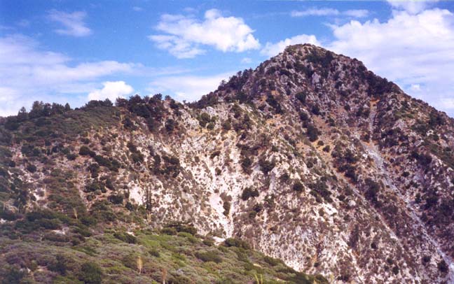
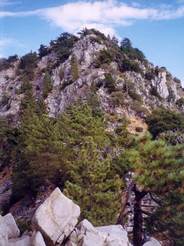
| Ridge approach to Strawberry | Strawberry Peak climb |
The ``off-trail'' and more challenging part of the hike begins at the saddle and follows the ridge all the way to the top of Strawberry Peak. In fact, the popularity of this hike means that there is a good use trail for most of the way. From the saddle, follow the trail that climbs eastward from the saddle. After just 20yds, leave the well-developed trail and branch right onto the use-trail that follows the ridge. Roughly 15min from the saddle you arrive at the first major obstacle. The decomposing granite rock of the ridge abruptly climbs about 100ft. There are several straightforward climbing routes over this obstacle that allow you to proceed without technical gear or excessive risk. I recommend proceeding upward on the right, then contouring around to the left where there are several chutes you can use to reach the top. It is also wise to take careful note of the route as you climb (and perhaps install a few ducks at strategic points). It is always harder to navigate while downclimbing and these notes or ducks will save time and energy during your later descent.
From a small summit (5445ft) a short distance beyond this first obstacle, you will see that the ridge loops to the north on its way to the summit of Strawberry Peak. Care should be taken to follow the trail that coincides with the apex of the ridge throughout. Indeed, if you are not on the ridge you have taken the wrong trail. As you approach the peak fir trees begin to appear and, shortly thereafter, you reach a rocky prominance from which there is a good view of the major obstacle on this hike, a steep boulder-strewn incline leading to the summit of Strawberry Peak. You should reach this point about 2hr 20min from the start.
From the vantage point of the rocky prominance it is a good idea to survey the climb up the steep face ahead. The route is marked by green arrows painted on the rocks and the first of these should be visible. Between the rocky prominance and the start of the climb is a small boulder-strewn area and it is necessary to descend about 50ft in order to traverse this. (Remember this descent for it is important to ascend it on your return in order to find the ridge trail.)
As you begin the climb, take time to check that you are on the right route. Be careful to follow the green arrows because, not too far to either side, there are steep and dangerous cliffs. Indeed the cliff on the left, on the north face of Strawberry is one of the highest in all of the San Gabriels.
Though it begins a little to the right, the route follows the apex of the ridge. Fortunately there are lots of good handholds and footholds so the climbing is quite straightforward. As you ascend the route moves to the center and you ascend along the apex. It takes about 20min to complete the climb and the 6164ft summit of Strawberry Peak (34o17.01'N 118o7.23'W) is just a short walk from there. It takes about 2hr 40min to hike from the trailhead to the top and distance of about 3mi.
The summit of Strawberry is a serene place with plenty of shade from which to admire the spectacular views. To the south, downtown Los Angeles is visible beyond the Mount Disappointment ridge and Brown Mountain. Further east the television towers of Mount Wilson pierce the skyline. To the north you look up the broad valley of Mill Creek toward Mount Gleason and the desert beyond.
The descent and return along the same trail takes about 2hr 20min.
Downclimbing the obstacles is somewhat harder than ascending so it is
necessary to proceed slowly and carefully.
Last updated 9/9/99.
Christopher E. Brennen