ADVENTURE HIKES AND CANYONEERING
IN THE SAN GABRIELS
© Christopher Earls Brennen

|
|---|

|
Hike C7. Supercloud Canyon
- Hiking time: 5 hours
- Estimated hiking distance: 3 miles
- Elevation gain: 800 feet
- USGS Topo Maps: Chilao Flat, Mount Wilson
- Difficulties: Six substantial rappels
- Special equipment: 190ft rope, 60ft webbing, rappelling equipment
-
ACA Rating: 3A III

Characteristics
The north face of the ridge that includes Mount Disappointment and San Gabriel Peak is one of the most rugged and precipitous in the San Gabriel range. It contains some marvellously sculpted canyons including the one that is visible to the south as you drive up the last couple of winding miles toward the junction at Red Box. This canyon has no name on the topo map - though the much less dramatic and smaller canyon below it to the northeast is called Cloudburst Canyon. One has to wonder whether the map maker may have misplaced the name. But the deed is done and so we have given the name Supercloud to the dramatic but unnamed canyon that is the subject of this adventure hike.
Supercloud is a highly recommended short adventure hike down through a vertical wonderland to a verdant tree lined, north-facing canyon. The head of the canyon is readily accessed and the drop-in is relatively easy. The descent involves six vertical waterfalls (usually dry) varying in height from 30ft to 90ft and surrounded by some spectacular scenery. Though it should be avoided during or after rain, the canyon can be quite dry during most of the year. It is, perhaps, most enjoyable during a dry fall or winter day.
Trailhead
The hike requires a car shuttle. Drive both vehicles up the Angeles Crest Highway from La Canada/Flintridge past the junction at Clear Creek and the Switzer Parking Area. Two miles beyond the Switzer Camp turnoff, the road makes a long sweeping turn to the left. At the start of this turn on the right side of the road there is a white metal gate where you will emerge at the conclusion of this hike (at 34o15.65'N 118o6.96'W and elevation 4010ft). Turn one vehicle around and leave it in one of the turnouts just before the gate and bend. From this parking area you can look south directly up at the sandstone walls of Supercloud. It looks very difficult from this viewpoint.
Then, in the other vehicle, proceed on up the road to Red Box Junction and turn right onto the Mount Wilson road. A short distance (0.4mi) beyond Red Box, a gated asphalt road (2N52) switchbacks up to the right. Drive a few yards up this road to the parking area before the gate (34o15.26'N 118o6.08'W and elevation 4750ft).
Hike
From the parking area (34o15.26'N 118o6.08'W and elevation 4750ft), proceed past the metal gate and hike up the asphalt road, 2N52, passing above Red Box junction. After 20min and 0.7mi you reach the first hairpin turn to the left (and the drop-in point for a different hike down Cloudburst Canyon which is on your right). Continuing on up the road, 1.7mi and 45min from the start you arrive at a second hairpin turn to the left at (34o15.04'N 118o6.65'W and an elevation of 5450ft. Just past the apex of this turn a broad trail or former fire road (with a small dirt berm across the entrance) branches off to the right. Follow the remains of this old dirt road as it contours off to the west below the ridge west of Mount Disappointment. Do not drop down into the canyon that you cross about 0.1mi from the asphalt road since it connects with Cloudburst Canyon. Instead continue on along the faint dirt road; about 0.3mi from the asphalt (1hr from the start) the dirt road ends at 34o15.03'N 118o6.82'W and an elevation of 5600ft; an animal trail continues to contour around the heads of Supercloud Canyon but you will drop into Supercloud here by proceeding straight down the steep slope at the end of the dirt road.
|
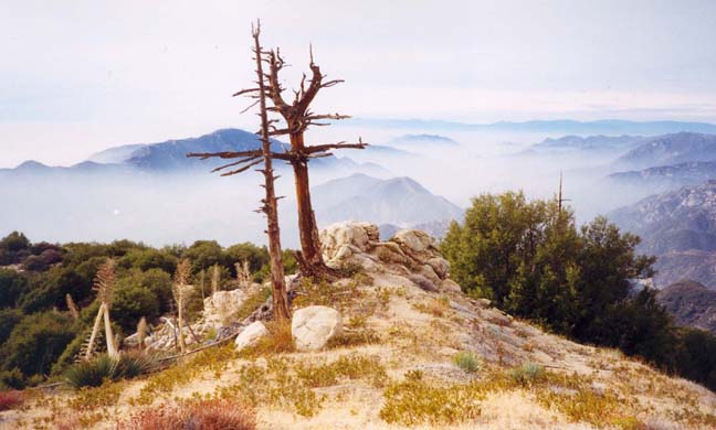
|---|
| View from the ridge |
Though steep the descent is quite easy since the surface is relatively fine sand and earth. Veer to the right into the bottom of the gully that soon turns toward the west. The stream bottom is relatively easy going until, 1hr 20min from the start at an elevation of 5150ft, you abruptly arrive at a lip with a jaw-dropping chasm ahead. However, closer inspection reveals a fairly straightforward descent. The first step is to rappel down beside the streambed to a long shelf about 50ft below. The anchor is a large tree some distance back from the lip on the left side. Having reached the shelf (elevation 5090ft) the second vertical drop looks very large indeed but appearances are quite deceptive. The anchor here is a stout bush on the right but it would be wise to back this up with a wrap around one of the rock projections just above the bush. The rappel from here is about 70ft to the bottom and the completion of the first big drop.
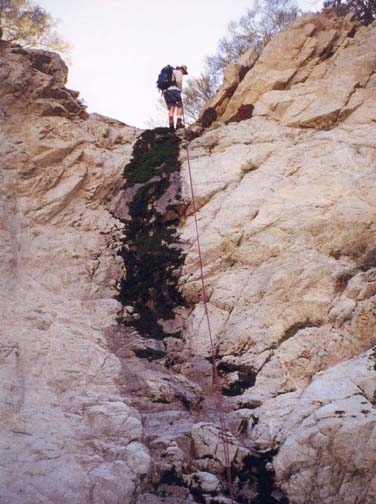 | 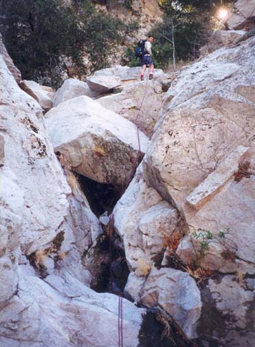
| |
|---|---|---|
| First rappel | Fifth rappel |
A short distance downstream of these first two waterfalls, a large canyon, perhaps the main canyon, enters from the left and there is a short stretch of bouldering before you enter a tree-lined section. At 4950ft and 2hr 20min from the start, you encounter a modest 30ft waterfall for which the best anchor is a large tree about 10ft up the slope on the right side. This is followed almost immediately by a small waterfall that can be bypassed on the left. After another short stretch of bouldering, you see ahead another lip that appears to lead to a second, massive chasm. A huge log lies across the top of this waterfall and closer inspection again reveals that the drop is quite manageable. The top of this fourth rappel is at an elevation of 4870ft and 2hr 40min from the start. The large log is a good anchor and the 50ft vertical descent involves some free rappel and pretty hanging moss decoration.
The fifth rappel (4800ft and 3hr from the start) is just a short distance downstream and consists of a stack of large boulders piled up above a narrow slot. The anchor is a stout small tree a short distance upstream on the left and the 35ft descent requires the negotiation of the boulders and a narrow chimney. Another relatively easy, tree-lined section follows before you arrive, 3hr 30min from the start (and at 4700ft), at the third awesome drop during this descent of Supercloud. This involves a 90ft vertical drop into a shady glade. A number of sizeable trees are growing out of the face of this waterfall and provide assurance of an intermediate anchor if this is needed. There are two possible anchors at the top, a stout bush on the right and a small tree on the left. It is probably best to use the former and to head for the right at the bottom since your 190ft rope may only just be long enough for a double rappel and the highest point at the bottom is on the right.
This completes the rappelling in this descent. It is a relatively short hike downstream to the junction with Cloudburst Canyon (entering on the right) at 34o15.46'N 118o7.00'W, an elevation of 4180ft) and 4hr 15min from the start. Just a short way below the junction you arrive at the top of two debris dams with stream center drops of about 12ft and 6ft. Off to the left in a flat area of forest are the ruins of an old house. The debris dams are readily negotiated on the left below the house. And 50yds below the dams a broad trail (fire road) crosses the streambed. Continue on down the stream bed and about 100yds further at 34o15.59'N 118o7.07'W and an elevation of 3990ft you encounter the fireroad again as it switches back. Go right along the trail; a short hike takes you back to the Angeles Crest Highway and the place where you parked the first car (34o15.65'N 118o6.96'W and elevation 4010ft) about 4hr 30min from the start.
Sidetrip to Supercloud Hollow
If you have time, you might choose to take a side trip (about 0.8mi and 1hr round trip) to an odd natural feature near the drop-in point for Supercloud. This is a large flat and bare depression on the ridge a short distance to the west. Supercloud Hollow (elevation 5310ft) measures about 100yds by 200yds and is an oddity that is worth a visit. There may be times after a major winter storm when it becomes a shallow lake.
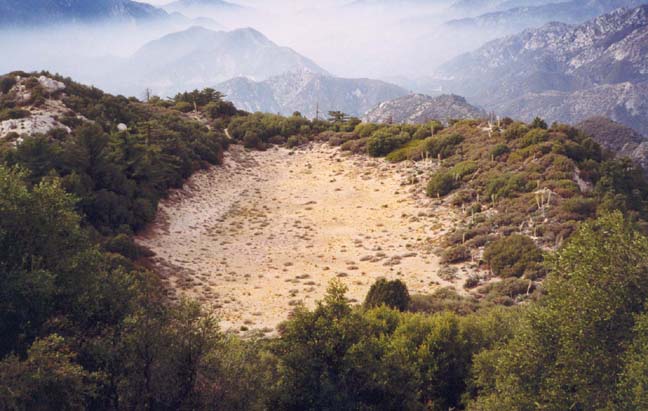
|
|---|
| Supercloud Hollow |
To reach the hollow, follow the animal trail that proceeds on beyond
the end of the dirt road at the drop-in point
(34o15.03'N 118o6.82'W and
elevation 5600ft). This trail
traverses across the scree slopes at the heads of the various branches
of Supercloud as it
climbs and contours up to the top of the ridge (elevation 5650ft).
There is a fairly
brushfree firebreak or animal trail along the top of the ridge and you
follow this west to the point where the hollow is clearly visible below you.
A broad firebreak descends several hundred feet directly to
Supercloud Hollow
(34o15.05'N 118o7.32'W and
elevation 5310ft).
After the visit, return to the ridge top and thence to the drop-in point for
Supercloud Canyon.
Last updated 1/1/00.
Christopher E. Brennen