ADVENTURE HIKES AND CANYONEERING
IN THE SAN GABRIELS
© Christopher Earls Brennen

|
|---|

|
Hike H2. Sheep Canyon
- Hiking time: 9 hours
- Estimated hiking distance: 8.5 miles
- Elevation gain: 3800 feet
- USGS Topo Maps: Cucamonga Peak, Mt. Baldy
- Difficulties: Large 260ft headwall descent requiring three-stage rappel; much bouldering
- Special equipment: Rappelling gear, two 60m ropes, 35ft webbing, 3 rappel rings, personal belay loops
-
ACA Rating: 4AR IV

Characteristics
Icehouse Canyon is one of the most attractive and popular hikes in the San Gabriel mountains. Each weekend, at almost any season of the year, you will encounter others enjoying the beautiful stream, the many sparkling pools and the mature pine trees for which Icehouse Canyon is justly famous. Many hikers follow the well-trodden trail all the way up to Icehouse Saddle and some even venture beyond to conquer one of the three peaks on the rim to the south (Cucamonga, Bighorn and Ontario Peaks) or one of the other row of peaks to the north (including Timber Mountain and Telegraph Peak). Few venture off the trails in this rugged and precipitous high country.
But the rim to the south provides several spectacular canyoneering adventures for those who are so inclined and this book features two adventure hikes in canyons that drop down Icehouse Canyon's precipitous southern wall. One of these, Falling Rock Canyon, is relatively easy and can be descended without technical equipment (see the Falling Rock Canyon adventure). The other, Sheep Canyon, features one spectacular 260ft drop, perhaps the most technically challenging descent in this whole book. It is also a beautiful hike, ideal for the late spring or fall.
Trailhead
The trailhead for this hike is the Icehouse Canyon parking area (34o15.00'N 117o38.11'W, elevation 4990ft), 1.5mi north of Mount Baldy Village in San Antonio Canyon. The access road to this parking area proceeds straight on at a fork where the road that continues up to the ski lift makes a sharp left turn.
Hike
From the parking area (34o15.00'N 117o38.11'W, elevation 4990ft), proceed up the well-marked Icehouse Canyon trail that parallels a sparkling, year-long stream. There are many cabins in the first mile or so, and also ruins of cabins that were destroyed by a flash flood in 1938. About 1.5mi from the trailhead you will come to a place where the trail crosses from the left to the right side of the stream. Just before this point you should be able to identify Sheep Canyon descending the steep, south wall of Icehouse Canyon to meet it about 34o14.91'N 117o36.98'W at an elevation of 5890ft.
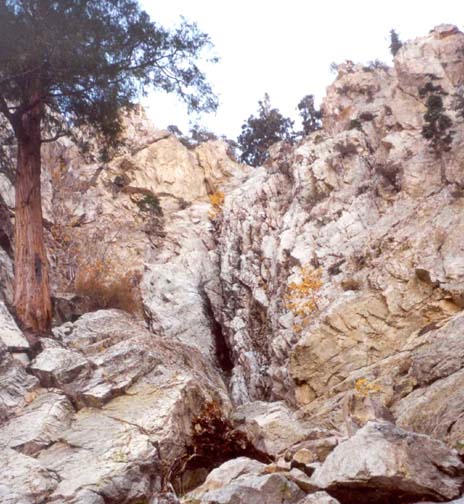 | 
| |
|---|---|---|
| Sheep Creek headwall | Lower Sheep Canyon |
Continuing up the maintained trail, you soon pass the sign for the Cucamonga Wilderness as the landscape becomes more rugged and open. The trail crosses back to the left side of the stream and steepens as it switchbacks up the north wall of the canyon. At 3.5mi and 2hr from the trailhead you finally reach Icehouse Saddle at 34o14.35'N 117o35.66'W and an elevation of 7550ft. Several trails come together at this point but you should identify the trail to Kelly's Camp and Ontario Peak. This doubles back along the south side of Icehouse Canyon, travelling in a westward direction. It rises gently as it traverses the wooded northern flank of Bighorn Peak and, after 0.7mi, arrives at the former site of Kelly's Camp (34o14.03'N 117o36.33'W, elevation 7840ft), marked only by a group of cabin foundations. This is a favorite camping site as you can tell from the remains of several fireplaces. The trail then switchbacks up to the top of a long east-west ridge that you follow all the way to its end at Ontario Peak (34o13.66'N 117o37.45'W, elevation 8693ft), some 2.3mi and 2hr from Icehouse Saddle. On a clear day the view from this rocky peak is magnificient. To the south there is a precipitous drop of several thousand feet into Cucamonga Canyon and, in the distance, you should be able to discern Catalina and, beyond that, San Clemente Island.
The canyon directly north of Ontario Peak is Cherry Canyon. It turns to the west and descends toward Baldy Village. Immediately to the east of Cherry Canyon is Falling Rock Canyon; the ridge between Cherry and Falling Rock begins about 200yds back along the trail from Ontario Peak. (Note that on the trail this ridge between Cherry and Falling Rock is not very prominent.) The head of Sheep Canyon is the next one to the east of Falling Rock. Consequently to access Sheep Canyon you should backtrack about 0.4mi around the head of Falling Rock Canyon and over the ridge seperating it from Sheep Canyon.
Contour part of the way around the head of Sheep Canyon to about 34o13.78'N 117o36.93'W and an elevation of 8550ft, drop in to it and follow the streambed as it develops. Soon Sheep becomes a quite bucolic, wooded canyon. The going is usually easiest a short distance up the earthen slope on the right or east side of the canyon. This allows you to bypass a number of boulder problems in the streambed bottom of the canyon. The fairly gentle descent continues for about 1.2mi.
At an elevation of about 6600ft and 2hrs from the drop-in, you will therefore be hiking down a pleasant wooded canyon when it makes a small left turn. Suddenly and quite unexpectedly you arrive at the top of an awesome drop at the bottom of which you can see the Icehouse Canyon bottom about 1000ft below you. You have arrived at the top of the Sheep Canyon headwall at about 34o14.69'N 117o36.98'W, a substantial rappelling challenge that should be attempted only by experienced climbers or canyoneers. The streambed first drops about 30ft into a gully, but this first minor obstacle is readily (though not obviously) overcome by clambering about 10ft up onto the rock ridge on the left. On the other side of this ridge is a steep scree gully that can be descended, bypassing that first obstacle. This takes you down to a platform at the top of the huge 260ft Sheep Canyon headwall. At this point you should not proceed unless you are confident of the skills needed to tackle the headwall. If you do decide to bail out, you can take the alternate descent route through Fir Draw. To access this, climb back up the scree gully and then ascend the apex of the ridge that climbs up and back from the lip. Initially steep, the gradient eases after several hundred feet and, by following the ridge through the woods, you should be able to locate the rim-trail (see Alternate Access Route below) that contours around the head of several steep canyons and then drops into a branch of Fir Draw that can be descended all the way to Icehouse Canyon bottom without the need for technical gear.
But for those with experience and skill, the descent of the Sheep Canyon headwall is a spectacular adventure. The first step is to thoroughly inspect the headwall drop from all the vantage points at the lip. Note first the route of the streambed that veers right near the cliff on that side. About 90ft down there is a lip that prevents you from seeing what lies below. You will also see a deep gully cut into the cliff off to the right, a watercourse that joins the streambed somewhere out of sight below the lip. Though you cannot see into that gully there are several small platforms down its length and one of these is the second staging point for this descent. Most importantly you should be able to identify a small to medium-sized pine tree growing out of the cliff approximately 90ft below you and midway between the streambed and the right wall. That tree is the first stop on the descent.
There are several possible anchors at the top; we used a wrap around a large boulder in the streambed close to the lip but there is also a large tree a little further back. Using the full length of a 60meter rope you can descend to the pine tree using a double-strand rappel. Team members should each have prepared a personal belay loop before they begin the descent so that they can tie in to the tree when they get there. Also, in order to reach the tree it is necessary to rappel down the streambed groove to a point where you can climb about 5ft up onto a slab to the right of the groove. Rapelling down the slab brings you to the pine tree anchor point. The alternative is to bypass the pine tree anchor by carrying two 60meter ropes, a plan that is necessary if the team numbers more than three. Otherwise, the second anchor is the tree and from there you first descend about 15ft to a broad shelf (not visible from above) and, from there, continue down into the aforementioned deep gully, landing on a broad platform in the gully bottom. This second rappel also requires the full length of a 60meter rope. The third stage is anchored from a large boulder on the gully-bottom platform. From there you first rappel down about about 25ft to a larger platform and then continue the rappel down another 20ft drop to the bottom of the headwall. Here you can stow the rappelling gear since the rest of the descent does not require technical equipment.
You should reach the bottom of the headwall (elevation about 6250ft) about 3.5hrs after the drop-in and 7.5hrs after the morning start. While there take time to enjoy this spectacular place. Unusual for the San Gabriels, the rock of the headwall is quite solid and could provide interesting rock climbing opportunities. This solid granite is in marked contrast to the crumbling rock of neighbouring Falling Rock Canyon. Note especially the great monolith adorning the leftside of the headwall; it would be interesting to know whether it has ever been summitted.
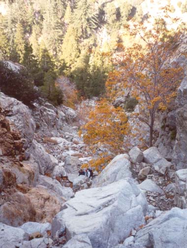
The descent from the bottom of the headwall to the stream in Icehouse House canyon takes about 35min; it is quite straightforward with only a couple of places where careful downclimbing is needed. The going is a mixture of scree, boulder-hopping and bedrock walking; there is virtually no brush barring the way. You cross the stream and clamber up to the Icehouse Canyon trail at a point about 1.5mi from the trailhead (34o14.91'N 117o36.98'W) at an elevation of 5890ft. Hiking down the well-worn trail you arrive back at the Icehouse Canyon parking area (34o15.00'N 117o38.11'W, elevation 4990ft) about 30min later.
Alternate Ascent Route
It is possible to access the top of the dramatic headwall in Sheep Canyon by a different and shorter route, but one that demands some careful navigation. This route proceeds up a canyon called Fir Draw that is just east of Falling Rock Canyon. Fir Draw is best located by hiking up the Icehouse Canyon trail while closely inspecting the cliffs on the south side. The first opening in these cliffs is Falling Rock Canyon (34o14.92'N 117o37.73'W, elevation 5260ft); it is about 0.5mi from the start and quite obvious despite the difficulty of peering through the trees. Fir Draw is the second opening about 0.7mi from the trailhead and at 34o14.89'N 117o37.57'W and an elevation of 5410ft; it is obscured by heavy brush and so can easily be missed. If you can you should enter Fir Draw on the right side where the brush is less thick but by no means absent. However, it peters out as you climb and the going on the boulders in the streambed becomes much easier. Having climbed about 400ft up Fir Draw to an elevation of 5800ft, you arrive at a large cliff-like obstacle in the canyon center. Take the left fork and continue to climb up the steep gully that is part scree and part boulders. A short way beyond the divide, the draw forks again and you should fork left again. Though this second fork may not be easy to recognize, you should proceed left only when the way, though steep, seems quite clear and straightforward. There are several possible steep gullies that you can follow here, the leftmost being bounded by a ridge with a precipitous drop on the other, eastern side. After a steep and exhausting climb all of these gully routes lead to a wooded rim and, in particular, to a rough animal/human trail that contours around the head of the gullies. You should reach this trail at 34o14.54'N 117o37.24'W and an elevation of 7010ft about 2hrs after leaving the trailhead. Follow this sometimes braided trail as it contours east around the head of several gullies until you arrive at Sheep Canyon, readily recognized as a deep wooded canyon cutting through this rough tableland. It is easy to descend about 300ft to the streambed in Sheep Canyon. At this point you will be several hundred yards above the lip of the headwall. This alternate access hike should take about 2.5hrs and therefore cut about 3.5hrs out of the hike. The difficulty is principally in navigating your way up the Fir Draw gullies to the rim use-trail.
Last updated 10/16/01.
Christopher E. Brennen