ADVENTURE HIKES AND CANYONEERING
IN THE SAN GABRIELS
© Christopher Earls Brennen

|
|---|

|
Hike K3. Pomeroy Canyon
- Hiking time: 4.5 hours
- Estimated hiking distance: 4.5 miles
- Elevation gain: 1340 feet
- USGS Topo Maps: Burbank, Pasadena
- Difficulties: 2 small rappels up to 30ft, some downclimbing
- Special equipment: Helmet, harness and rappeling gear; 120ft rope, 20ft webbing and 2 quicklinks
-
ACA Rating: 3A II

Characteristics
The Verdugo Hills can be likened to an offshore island of the San Gabriels. Towering about 2000ft above Glendale and Burbank they are seperated from the San Gabriels only by the 210 Freeway. Though not officially part of the Angeles National Forest they represent a valuable additional piece of wild land and one whose extensive trail system is widely used and enjoyed by hikers. As yet we have not found any very good canyoneering locations in the Verdugo Hills but we include here this descent of Pomeroy Canyon in order that the Verdugo Hills be at least represented. Pomeroy Canyon does have two small rappels but the bushwhacking required to descend it from the top makes it only marginally attractive. It is best done during the cooler winter months.
Trailhead
This hike requires a car shuttle. To deposit the return vehicle take the Western Avenue off-ramp from the Golden State Freeway (I5) in Glendale and drive northeast on Western all the way to the end of that street. Turn right onto Mountain and after a few hundred yards turn left into Brand Park. Drive up to the parking lot beside the public library and leave the return vehicle there (34o10.94'N 118o16.60'W and elevation 830ft).
Then, in the other vehicles, drive back down Western to the I5, south on the I5 and transition to the eastbound 134 freeway. After a few miles transition to the northbound Glendale freeway (State route 2) and take the first off-ramp from that freeway onto Mountain Street. Drive west on Mountain and, at the bottom of the hill, turn right onto Verdugo Road. After a short distance this forks left and becomes Canada Boulevard. After about 0.5mi turn left onto Colina Drive, which, after about 200yds, veers left and becomes Sunshine Drive. Follow Sunshine as it winds up into the foothills. Park on the right side of Sunshine Drive just before the point where Sandringham Drive takes off on the left (further up Sunshine Drive you are likely to get a parking ticket). Your parking location should be 34o14.98'N 118o15.18'W and your elevation 2335ft.
Hike
From the point where you parked (34o14.98'N 118o15.18'W and elevation 2335ft), hike up Sunshine Drive to the closed gate and continue up the short asphalt road beyond the gate. This soon gives way to a well-maintained dirt road that climbs steadily into the Verdugo Hills. About 1hr from the start you contour over a ridge where there is a prominent utility pole; now you are looking down into the Pomeroy Canyon basin. Off to the northwest and just to the left below a group of radio towers you should see a white rock prominence that marks the point where we drop into Pomeroy Canyon. Continuing up the road you soon encounter a junction some 2.4mi from the start at 34o11.30'N 118o15.38'W and an elevation of 2400ft; here the roads are signposted and you should continue along the left route signed the "Verdugo Motorway". The road descends for about 100yds to a saddle and just beyond this saddle you should leave the road on the left and follow the use-trail along the ridge-top. Soon this ridgetop trail climbs to a summit overlooking the white rock prominence described earlier. You should reach this summit about 1hr 20min from the start.
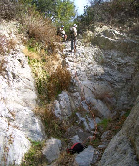
|
|---|
| First rappel |
From the summit, proceed down the steep, rough use-trail toward the white rock prominence. But just before reaching this goal, contour left into the nearby gully and begin descending the gully which requires some light bushwhacking. In many places there are animal tracks that provide easy passage. After about 45min of descent down through an elevation of 2000ft, the going begins to get more difficult and it is easier to find a high path along the left wall that avoids the thick plant growth in the canyon bottom. Eventually after about 2hrs of descent at an elevation of 1500ft you finally arrive at the top of the first rappel, a 25ft drop that can be anchored from a large tree trunk a short way back from the lip. The second and last rappel is just a short distance downstream. Anchored by a chockstone a short way upstream this second rappel descends about 30ft down a broad chute that doglegs to the left.
At the base of this second rappel you encounter the well-worn trail (it becomes
a fire road a little higher up). You follow this trail (and later road) down
the watercourse all the way to Brand Park and your return vehicle at
34o10.94'N 118o16.60'W and an elevation of
830ft. The complete hike should take about 4.5hrs during which
you cover about 4.5mi.
Last updated 11/5/07.
Christopher E. Brennen