ADVENTURE HIKES AND CANYONEERING
IN THE SAN GABRIELS
© Christopher Earls Brennen

|
|---|

|
Hike D11. Pasadena Glen
- Hiking time: 11.5 hours (13 hours if you take Option 2)
- Estimated hiking distance: 6 miles
- Elevation gain: 1870 feet
- USGS Topo Maps: Mount Wilson
- Difficulties: About 9 to 12 rappels ranging in height from 25ft to 80ft, many smaller waterfalls and much bouldering and scrambling
- Special equipment: Full rapelling equipment with a 160ft rope, a 120ft rope, a 120ft recovery cord, 150ft of webbing, 10 rappel rings and, as insurance, a bolt setting kit.
-
ACA Rating: 3B IV

Characteristics
Pasadena Glen drops steeply through the foothills north of Pasadena and provides a substantial challenge both in terms of the number of waterfalls and rappels and the degree of difficulty of several of them. Water flows year round in the Glen but the hike is best undertaken in the summer months since you are likely to take a soaking two or three times during the descent. There is also sufficient shade from the summer sun. The hike should not be undertaken in the winter or at times of heavy or even moderate run-off for this would make some of the rappels almost impossible. The Glen is very pretty in places and, were it not for the difficulty of lowering full packs down some of the rappels, it would make a better two-day adventure.
Trailhead
This hike requires a car shuttle. First you must deposit a return vehicle at the exit from Pasadena Glen. From New York Drive in eastern Pasadena, drive north on Sierra Madre Villa Drive and turn right onto Vosberg Street. This drops into Pasadena Glen and you should park the return vehicle in the turnout (at about 34o10.61'N 118o4.73'W and elevation 1230ft) on the left just after the road crosses the stream since there is little parking further up Pasadena Glen Road.
Then return to New York Drive, and turn right and proceed to Altadena Drive where you turn right again. The trailhead is the start of the Mount Wilson Toll Road (2N45) in Altadena. Drive north on Altadena Drive, turn north on Mendocino Lane and immediately east on Pinecrest Drive. You may have to park on Mendocino because of parking restrictions on Pinecrest. But it is still just a short way along Pinecrest to the gate on the Mount Wilson Toll Road (34o11.51'N 118o6.33'W and elevation 1300ft).
Hike
Proceed down the Toll Road to the bridge across the mouth of Eaton Canyon (elevation 1250ft) and on up the Toll Road past Henninger Flats. After several switchbacks above the Forest Service buildings, locate an old, disused fire road that branches off the right side of the Toll Road at 34o11.66'N 118o5.16'W and elevation 2900ft approximately 200yds before the saddle and T-junction above the Flats. You should reach this point about 1hr 15min from the start. The junction with the disused fire road is quite indistinct because of many washouts; it is opposite a large water tank that is below you on the left of the Toll Road. The disused fire road switches back toward the southeast and contours around the south side of the hill above and to the east of Henninger Flats. There is a moderately good trail along it though the road itself is washed out in many places.
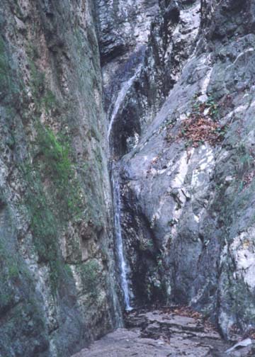 | 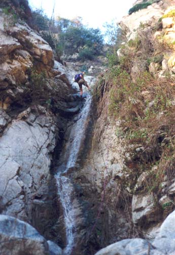
| |
|---|---|---|
| Narrows in upper canyon | Big falls |
The trail ascends gradually in order to surmount the prominent ridge that forms the western wall of Pasadena Glen. You will reach the summit (elevation 3120ft) where the fire road crosses this ridge about 30min after leaving the Mount Wilson Toll Road. Make a careful mental note of the ridge and of the use trail along it that goes all the way down to the valley below. This trail represents an escape route from Pasadena Glen since there are several places in the canyon where you can climb up to the ridge.
But your route continues along the disused fire road as it flattens out and then begins a gentle descent into Pasadena Glen. At one point a short distance beyond the summit, you will pass about 200ft below another saddle on the Mount Wilson Toll Road. Though you will encounter wash outs with increasing frequency (and several require careful negotiation), continue along the trail until it finally vanishes. This occurs about 100yds past a major washout and at a headland (elevation 3140ft) where you can see the canyon bottom and its trees about 150ft directly beneath you. It is important that you do not try to descend into the canyon too soon for you would then have to negotiate a very large cliff that cannot be seen from above. Instead follow the trail until it vanishes and take the next gully leading down into the canyon. The descent is straightforward except, perhaps, for the last 25ft which is quite steep. You should arrive in the canyon bottom (elevation 3000ft) about 2hr 40min from the start.
Immediately below the point you have reached in the canyon bottom is a rugged section in which the stream first drops about 150ft and then makes an abrupt left turn through a narrow chasm containing several water falls. There are two options here.
Option one is probably the wisest given the length of this hike and the difficulty of following the stream. It is to bypass the difficult series of waterfalls immediately ahead of you. To do this, climb a short distance up the earth slope on the left side directly opposite the point where you descended into the canyon and just above the first large waterfall. By climbing a short way up to the ridge at the top of the earth slope you can then cut the corner and descend a steep and rough slope to access the bottom downstream of the very narrow section of canyon.
Option two is to follow the stream through the first section and complete the three rappels that are necessary to negotiate it. The first waterfall is a modest and straightforward 20ft rappel using as anchor one of the small trees a little way up the right bank. The second waterfall follows immediately and requires a 100ft rappel. The only available anchor is a large tree high on the left; it is an awkward climb to access this tree. Having completed this long rappel, you find yourself in a small open area surrounded by cliffs with large waterfalls on two sides. The exit from this space is a very narrow chute with an abrupt left turn about 15ft below you so that you cannot see what follows. In fact there is a further drop of about 10ft followed by a long narrow pool and then a further vertical drop of about 20ft. This is a very awkward rappel, particular when the stream is flowing full. There is no problem finding an anchor for there are several fallen trees nearby. But you need about 200ft of rope for a double rappel and the rope recovery can be very difficult due to the abrupt corner. However, you can climb up on the right and circumvent this waterfall if need be. Option two does, however, require a considerable additional expenditure of time (about 1hr 30min) relative to option one and therefore results in a very long day.
Moving on down the canyon from the point where option one descends, you find a 20ft waterfall followed by a series of three measuring 15ft, 40ft and 10ft. All of these may be bypassed on the right side. On a ledge above and to the right of the 40ft falls you will find pipes that are the remains of an old water supply system. Descend to the bottom just around the corner from this ledge.
Up to this point you can still climb back up along the route you have come but the point of no return lies just ahead where you must rappel down a V-shaped slot about 35ft high. The anchor for this rappel is on a small tree about 10ft above and to the right of the entry to this slot. To reach it requires a short free climb that is sufficiently exposed to need a belay. Immediately below this slot are a series of small falls one or two of which may require some assistance from a rope or piece of webbing.
There follows a relatively flat section in the middle of which is a small 15ft waterfall with no obvious anchor. However, with the assistance of a belay it is relatively easy to downclimb just to the left of the water.
A short distance below this, the flat section ends with a sudden precipitous drop of about 80ft in several stages, namely a 15ft drop to a small rocky ledge followed by a 60ft vertical section and several small, additional falls at the bottom. The anchor for this descent is a large tree to the right above the first drop; this neccessitates a single strand rappel. Below this is another brief flat section that contains one 20ft rappel that utilizes a large rock on the right as the anchor. Then you encounter a rocky crevasse waterfall that has a shelf one third of the way down and a very thick log propped against the bottom. The anchor for this rappel is a small but firm tree about 10ft up the cliff on the left some 30ft upstream of the lip. Another small rappel follows and a waterfall in a left hand turn that can be downclimbed on the left. Some distance downstream you encounter another small waterfall with the prominent rocky knob on the right. This can be circumvented by climbing around the upper, right side of the knob (incidentally a trail heads up the canyon side at this same knob and connects with the trail high up on the ridge to the right). You should reach this point about 9hrs from the start, assuming you have taken Option 1 just after the drop-in.
The canyon continues along a rough but fairly easy section for several hundred yards until it arrives at a memorable broad waterfall with water cascading down on either side of a central rocky slope. At the bottom water also emerges from a tunnel on the left. This is readily downclimbed along the central rocky slope but, below this, the canyon enters a narrow, dark section and you must rappel down a fifteen foot waterfall with a small 5ft section immediately following. The anchor for this is a large boulder in mid-stream just above the lip. Another rough section of over 100yds follows before you encounter a left turn with two awkward, small waterfalls that can be downclimbed but may also require a rappel (there is no anchor in between so you must rappel both). The next waterfall can climbed around on the left and, after a small 6ft drop, you finally arrive at the last waterfall and rappel in the long adventure hike. Here the canyon again narrows to a slot and makes an abrupt left turn. There are several small trees just before the turn that make a good anchor. However, I recommend using (as we did) a long piece of webbing that reaches around the corner in order to make rope retrieval easier. The rappel itself is about 20ft down through the center; it is hard to avoid getting very wet here when the stream is flowing at normal levels.
Below this final rappel the canyon turns right and it is only about
50yds to the end of Pasadena Glen Road
(34o10.92'N 118o4.74'W and
elevation 1400ft). Hike down the road to your parked vehicle.
The entire hike will take up a whole summer day, about
11hrs 30min (13hrs if you take Option 2)
and therefore requires a very early start.
Last updated 7/30/99.
Christopher E. Brennen