ADVENTURE HIKES AND CANYONEERING
IN THE SAN GABRIELS
© Christopher Earls Brennen

|
|---|

|
Hike D16. Monrovia Canyon
- Hiking time: 8 hours
- Estimated hiking distance: 4.9 miles
- Elevation gain: None
- USGS Topo Maps: Asuza
- Difficulties: Very rough terrain with bushwhacking, rough climbing and about 11 rappels, several about 50ft in height
- Special equipment: Full rapelling equipment with a 160ft rope, 100ft of webbing and 10 rappel rings.
-
ACA Rating: 3A IV

Characteristics
Monrovia Canyon drops rapidly down from the 5000ft ridge that rises precipitously above the foothill communities of Arcadia, Monrovia, Bradbury and Duarte in the San Gabriel Valley. Monrovia Canyon and its tributaries form a bowl that is home to much wildlife including several bears. Because of the steepness of the terrain, a descent of Monrovia Canyon involves about ten rappels and is a demanding day hike even for the experienced adventure hiker. In the summer most of canyon can be negotiated without getting wet above the knees but the situation may be quite different in winter or spring. The terrain is ruggedly beautiful from the wooded upper reaches, down through a narrow slot where the canyon turns south, to the bucolic lower reaches in the forest of Monrovia Canyon Park. It is a fun summer adventure hike for experienced hikers.
The canyon is accessible because it begins close to the Rincon/Red Box fire road that runs along the top of the aforementioned ridge. There are, however, two strategic difficulties with the hike. The first is unavoidable, namely that accessing the head of the canyon is time consuming and involves a very long car shuttle. The other is the foolishly limited opening hours of the Monrovia Canyon Park whose rangers neurotically lock the gates to the park outside the opening hours of 8.00am to 5.00pm. Since it is virtually impossible to complete the hike within this time frame, you must park outside the park, thus extending the hike by about a mile.
Trailhead
To place the return vehicle drive north on Canyon Boulevard in Monrovia. Follow this as it turns right near the top and proceed a few hundred yards to the point where you fork right following the signs for Monrovia Canyon Park. You should park at the roadside just south of this point (34o9.90'N 117o59.71'W and elevation 930ft). However, to ensure that you have found the right place continue up Canyon Boulevard following the signs for the park. At a point just west of the debris dam you will encounter the gate that opens at 8.00am. Since this may be closed when you arrive here in the evening you must turn around and drive back down to the nearest available parking location which is, as we mentioned, just south of the road fork.
In the other vehicle you should then proceed back down Canyon Boulevard, turn left onto Foothill, and then right onto Mountain. This will take you to the 210 Freeway. Drive east on the freeway to Azusa Avenue, Highway 39 and proceed north on 39 into the mountains to the Forest Service Station at Rincon. Just past the station on the left is the locked gate leading to the Rincon/Red Box fire road. To enter you need a free permit that you must obtain at one of the local Forest Service offices within a month prior to the hike. At that time they will provide you with the combination for the gate lock.
The fire road (usually kept in good condition) ascends to the east/west ridge that separates the valley of the West Fork of the San Gabriel from the LA Basin. There are two junctions where care may be needed for they often lack signposts. The first occurs at a broad clearing where the spur road to Pine Mountain (4539ft) branches off to the right while the main route proceeds to the left. The second can be quite deceiving and occurs about the nine-mile marker. The main road makes an abrupt right turn into a cutting while the route straight ahead is soon blocked by a gate; the fire road beyond the gate descends to meet the road that rises through Sawpit Canyon from Monrovia Canyon Park. Assuming you stay on the main road then, about 13mi beyond Rincon you will arrive at the junction with the Upper Clamshell Road at an elevation of 4720ft. The gate blocking the Upper Clamshell is just a few yards to the left and readily visible from the main road. There is also a small parking spur at 34o13.01'N 117o58.52'W and an elevation of 4720ft. You should leave your vehicle there. All of this is almost underneath a large electricity pylon.
Hike
Walking around the gate (34o13.01'N 117o58.52'W and elevation 4720ft) you gain the Upper Clamshell Road. Proceed downhill for about 100yds to where there is a fork in the dirt road beside the upper reaches of the East Fork of the Santa Anita river. Take the left fork and pass through another gate. The road levels out and winds through a pleasant pine forest with a steep drop on the right down into the East Fork of the Santa Anita. About 30min and 1.3mi from the start (at an elevation of 4700ft), the road emerges onto a ridge top that has a steep dropoff on the left as well as the right. The drop in point for Monrovia Canyon is on your left at 34o12.35'N 117o58.79'W. As soon as you emerge onto the ridge top, cross over the firebreak and find a faint gap in the bushes where an animal trail proceeds straight down the dirt slope. Though steep the route is moderately easy going and there are relatively few bushes due to the tree coverage. Veer right a little with the trail as it transitions into slightly larger gullies.
 | 
| |
|---|---|---|
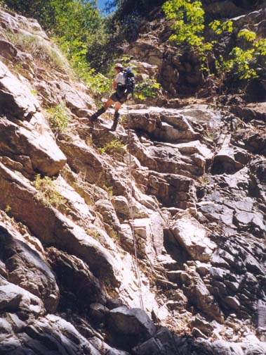
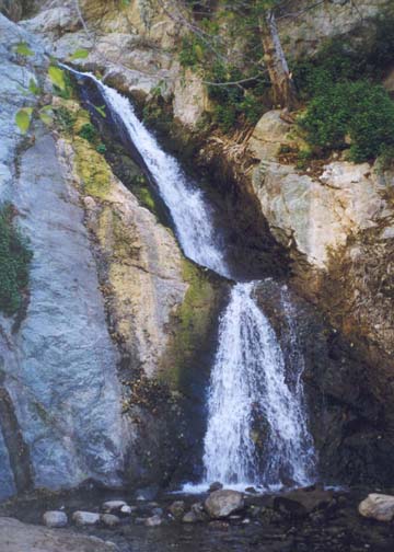
| Second rappel in upper canyon | Monrovia Falls |
As the steepness of the descent eases and the canyon begins to deepen, a gully of roughly equal size connects in on the left. This junction is roughly 1hr 15min from the start and at an elevation of 3800ft. A little further on at the end of a moderately easy section, you reach the first serious obstacles, a 30ft dryfall that can be bypassed on the right followed, a few yards down the canyon, by a simple 20ft rappel with a substantial tree anchor on the left lip. Some distance downstream at an elevation of about 3420ft and 2hr 10min from the start you will encounter a 40ft rappel through a broad slot into a bowl that makes the drop seem larger than it is. The anchor is a tree high at the top of a dirt slope on the right. Though it is not readily apparent this waterfall can, in fact, be downclimbed on the right by contouring up and over the rock ridge on that side.
As you reach an elevation of about 3300ft about 2hr 45min from the start, the canyon narrows to a short but dramatic gorge. Here you encounter perhaps the best rappel of this hike, a 50ft drop with some free rappel. The anchor is a large tree root system on the left. Then, about 15min beyond these narrows, you arrive at the top (elevation about 3000ft) of what looks like a very challenging, steep and narrow slot whose end cannot be discerned from the top. It is not however as difficult as one might fear from that first sight. The first section involves two small 15ft rappels using as anchors a boulder on the right and then a small tree on the right. The second is followed almost immediately by another 15ft drop that could be a continuation of the second rappel or could be downclimbed. Below this, a very new rockfall has altered the slot bottom. It should be downclimbed with care for some of the rocks are quite unstable. The slot then begins to widen somewhat and, near the bottom, there is a 30ft rappel using a large boulder anchor on the left. A short distance downstream the canyon makes a major turn to the left. As you make this turn (about 2.4mi from the start) the San Gabriel Valley becomes visible in the distance for the first time. Just at the turn there is another 30ft rappel using a rock anchor on the right followed by another smaller 20ft rappel again using a boulder anchor.
At this point you will have reached an elevation of 2800ft after almost 5hrs of hiking. You now enter a section of more open but still steep canyon with many small recent rockfalls and a series of moderate downclimbs. In several places, a belay would be wise for those less sure of their rockclimbing ability. In one place a passerby has left a small rope to assist in sliding down a 12ft incline. The valley seems just a short distance away but this is quite misleading; 3hrs of rough travel are still needed to reach it.
Just as it seems the going is getting easier, you arrive at the top of a major obstacle where a huge boulder has blocked the canyon. The waterfall is to the left side of this boulder; the right side has a slot with chockstones at the top that provide a good anchor. The rappel is about 40ft in two distinct steps, the first being awkward due to the narrowness of the slot. Just downstream is another substantial waterfall that can be downclimbed to the left of a boulder on the left, though with some difficulty. A series of easier downclimbs (mostly on the right) follow before the canyon narrows again. Here there is an easy 30ft rappel using a large boulder anchor on the right. This leads into a short narrow section that can be traversed using a ledge on the left as the canyon turns in that direction. Downstream of this is a relatively long wooded section in which the going is fairly easy. This ends where the canyon narrows again and, after a small but awkward downclimb on the right, you arrive at the top of Monrovia Canyon Falls, a distance of 3.2mi from the starting point.
Monrovia Canyon Falls are at the terminus of a popular, short trail
hike up the canyon from Monrovia Canyon Park.
The 50ft waterfall effectively blocks progress
upstream by all but the experienced rock climber. The rappel
down is best to the right of the waterfall using as anchor either
a large boulder in the stream just above the falls or one
of several anchors higher up on the right.
The base of the waterfall (elevation 1760ft) should be reached
about 7hr 30min
into the hike and from this point it is simply a matter of following
the maintained trail down into Monrovia Canyon Park, a distance of
0.75mi to the asphalt road (3.9mi from the start
at 34o10.58'N 117o59.46'W and
an elevation of 1260ft). Then comes the
frustrating part; it is still another mile down the road to where you had to
leave the return vehicle outside the park gates.
Last updated 7/30/99.
Christopher E. Brennen