ADVENTURE HIKES AND CANYONEERING
IN THE SAN GABRIELS
© Christopher Earls Brennen

|
|---|

|
Hike B9. Mary Jane Canyon
- Hiking time: 6 hours
- Estimated hiking distance: 2.7 miles
- Elevation gain: 1200 feet
- USGS Topo Maps: Condor Peak
- Difficulties: Navigation, bushwhacking and 10 rappels up to 120ft
- Special equipment: Rappelling equipment with 200ft rope, 100ft rope, 10 rappel rings and 150ft webbing
-
ACA Rating: 3A III

Characteristics
Mary Jane Canyon, like its neighbors Vasquez, Silver and Suicide Canyon, is a north-facing canyon in the Big Tujunga region that provides an exciting canyoneering adventure with many rappels. Unlike those neighbors access to the top presents a navigational challenge as well as a serious bushwhacking effort. However, once those challenges are surmounted, the canyon itself is relatively brush-free and provides a very pleasant wooded canyoneering environment with about ten straightforward rappels with one inclined 120ft drop and one vertical 80ft drop.
At the conclusion of the descent you must cross the Big Tujunga River in order to get back to your return vehicle and this might be problematic in the winter or spring after heavy rains (though the flow is controlled by the dam just upstream and can be unpredictable). It would therefore be wise to check the river when you deposit the return vehicle prior to setting out in the morning. Other than this constraint, the hike could be undertaken almost any time during the year though it might be too hot in the summer.
Trailhead
This hike requires a car shuttle. First drive to the parking area at the southwest end of the bridge on Big Tujunga Canyon Road just downstream of Big Tujunga Dam. The coordinates are 34o17.02'N 118o11.85'W and the elevation is 2150ft. This is where you should leave the return vehicle(s). Then drive 3.1mi east on Big Tujunga Canyon Road to its junction with the Angeles Forest Highway where you should turn right and proceed 3.8mi to the Clear Creek junction with the Angeles Crest Highway. Turn right here and proceed down the Angeles Crest Highway for 3.2mi to a place where a fire road climbs up from the road (it is about 6mi north of La Canada). As you go downhill, the Angeles Crest Highway makes a sweeping left turn at this point and there is a large dirt parking area on the right (34o15.62'N 118o11.54'W). The fire road that starts here is labelled 2N79.
Hike
From the dirt parking area (34o15.62'N 118o11.54'W and elevation 2940ft), proceed past the locked gate and hike up fire road 2N79. After 0.6mi (about 15min) you arrive at a fireroad junction at 34o15.72'N 118o11.43'W marked by a water tank a little distance away on the right. Take the right fork and proceed about 0.3mi up the road to a point where you can see a low saddle above you on the left. Leave the road here by way of a rough trail through the brush and climb up to the saddle at 34o15.95'N 118o11.50'W and an elevation of 3480ft. A fairly brush-free firebreak runs north up the mountain from this saddle and you should hike a short way up this firebreak while watching for a trail that leaves the firebreak and contours left along the remains of an old, overgrown fireroad. This trail branches off the firebreak at 34o16.05'N 118o11.47'W and an elevation of 3620ft and may be marked by an orange ribbon. Contouring northwest this trail intersects another steep ridge with another firebreak at 34o16.16'N 118o11.64'W and an elevation of 3670ft. From this point there is a spectacular view of Mount Lukens to the south and of the lower Big Tujunga off to the west. From here, hike the rough use-trail up this steep firebreak all the way to the ridge top at 34o16.26'N 118o11.45'W and an elevation of 4140ft.
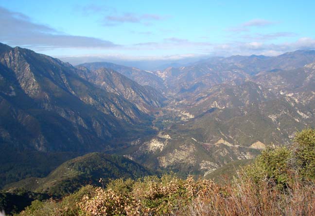
|
|---|
| View from the ridge |
You should arrive at the ridge top about 1.5mi and 1hr 20min from the morning start. This is where the primary challenge of this adventure begins for one must negotiate thick brush ahead and navigate down into the head of Mary Jane Canyon. A good GPS is of value in this effort for it is hard to maintain your direction in the thick brush. As far as possible, it is advisable to try to follow the trail that our group cut in Dec. 2006. The trail begins by following the ridge top down for about 100yds where the really thick brush begins and then gradually veers right down the east side of the ridge. Fortunately the brush thins as you descend and the going becomes much easier as you enter a forested area. If you managed to follow our trail then it will lead directly into the gully at the start of Mary Jane Canyon. This gully is earthy and brush-free, making for a rapid and unimpeded descent in marked contrast to conditions on the ridge just a brief time before. This easy going continues as you descend through 3500ft and then 3000ft. Finally at an elevation of 2950ft and 3hrs from the morning start you rather abruptly arrive at the top of the first series of rappels.
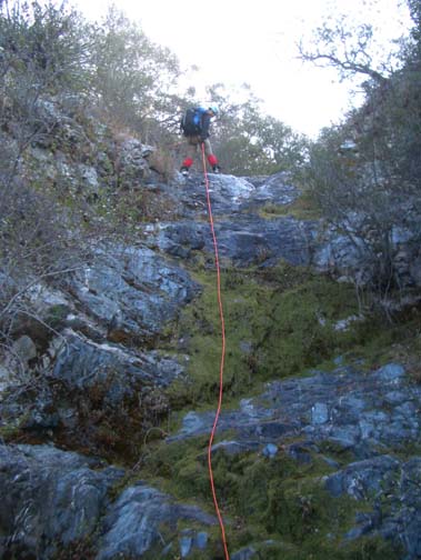 | 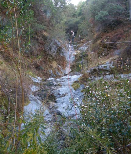
| |
|---|---|---|
| Second rappel | Penultimate rappel |
This first technical challenge in Mary Jane Canyon consists of a long series of steps that can be descended in two or three rappels. The first short drop is a 10ft rappel from a tree anchor on the left side a little way back from the lip. This leads to a shelf with a tree on the right that can be used to anchor a 50ft rappel down to another shelf where another tree on the right anchors another 50ft rappel to the bottom of this series of steps. This is followed by a short section of hiking during which a small gully comes in on the left at 2770ft. Then at 2740ft there is a series of slide/downclimbs where some may need a reassuring belay and, a short time later, a single 15ft rappel from a tree anchor high on the left. Another short hike down to 2470ft will bring you to the top of an inclined 50ft climbdown/rappel which is probably best rappelled using the tree anchor on the right. Just downstream you arrive at the top of the last rappel before the major Mary Jane confluence. This is a 30ft rappel from a tree anchor on the right and it drops you down to the confluence where a major tributary of Mary Jane Canyon enters from the left. You should reach this confluence at 2370ft about 4.5hrs from the morning start.
The confluence has two large canyon-spanning logs that are worthy of note and, perhaps, of closer inspection. One huge log spans the canyon just downstream of the confluence while another spans the adjoining canyon just above the junction. Continuing downstream, you will come to a small 25ft rappel at 2310ft that is anchored by a tree on the left and, shortly thereafter, another 20ft step that is rappeled from a tree on the left. Finally, about 5hrs from the morning start at an elevation of 2250ft you will come to the top of the final series of rappels in Mary Jane Canyon. The first of these is a series of inclined steps that require a 120ft rappel from a tree anchor on the left. This leads immediately to the top of the last rappel, an 80ft vertical drop anchored by a large tree at the lip. This last rappel deposits you in a cliff-ringed enclosure with the Big Tujunga drainage just a short 10ft drop away but you will need to climb up on the left side and then use the trees and roots to get down there. You should reach the Big Tujunga at 34o16.85'N 118o11.95'W and an elevation of 2030ft having travelled about 2.5mi from the morning start.
The next challenge is to cross the Big Tujunga River in order to make it back to your return vehicle at the far end of the bridge which is now visible off to your left. This crossing is readily accomplished in the summer or fall (though you may get wet) but could be quite problematic in the winter or spring after heavy rains. It would be wise to check the river from the bridge when you leave the return vehicle there prior to the hike.
Having crossed the Big Tujunga, you then hike up the fireroad that leads to the
west end of the bridge and to your return vehicle at
34o17.02'N 118o11.85'W
and an elevation of 2150ft. During the adventure, you will have
covered a distance of
about 2.7mi in about 6hrs.
Last updated 12/09/06.
Christopher E. Brennen