ADVENTURE HIKES AND CANYONEERING
IN THE SAN GABRIELS
© Christopher Earls Brennen

|
|---|

|
Hike B12. Lower Fox Canyon
- Hiking time: 7 hours
- Estimated hiking distance: 9 miles
- Elevation gains: 770 feet and 580 feet
- USGS Topo Maps: Condor Peak
- Difficulties: One 60ft rappel into a pool over 6ft deep; some bushwhacking, bouldering and wading
- Special equipment: Rappelling gear with 120ft rope, 30ft of webbing, 1 rappel ring, dry bags
-
ACA Rating: 3B III

Characteristics
Fox Canyon is a tributary of Big Tujunga Canyon and joins the latter a little distance upstream of the reservoir behind Big Tujunga Dam. It contains the most spectacular series of waterfalls in the San Gabriels, one of which is about 100ft high. These waterfalls are little known because of the difficulty of reaching them. The route up Fox Canyon is blocked by a 60ft waterfall near the canyon entrance and access further up the canyon involves some cross-country bushwhacking.
This hike in lower Fox Canyon is the easier of the two Fox Canyon hikes described in this book and it is recommended that you complete this difficult adventure before undertaking the very difficult Great Falls of the Fox hike. Even the present hike is a strenous and demanding adventure that is only for the experienced adventure hiker with substantial rappelling experience.
The middle part of the hike, during which you descend two small side canyons in order to access the middle section of Fox Canyon, involves some bushwhacking. But the reward is a marvellous close-up view of the Great Falls of the Fox and an exciting rappel down the 60ft Lower Fox Falls in order to exit the canyon.
Trailhead
The trailhead for this hike is a dirt parking area (at 34o17.82'N 118o10.20'W and elevation 3090ft) by a locked gate on Big Tujunga Canyon Road, 0.5mi southwest of the junction with the Angeles Forest Highway.
Hike
Proceed through the locked gate (34o17.82'N 118o10.20'W) and start down the dirt road (5N27). Pause at the overlook about 100yds from the gate in order to get your bearings. Looking straight down into the canyon bottom you will see the gravel flats that occupy the canyon floor upstream of the reservoir itself. If there is standing water below this point you should review and perhaps revise your plan for you will later be crossing these flats.
Next, you should identify the large mountain that dominates the skyline to the northwest on the far side of the canyon. This is Fox Peak with Condor Peak behind it. Now look down into the canyon slightly to the right of this peak and you will see a fairly large tributary canyon joining the Big Tujunga. This is Fox Canyon and you can look directly into it from this viewpoint at least as far as the point where it makes an abrupt turn to the right. Just before this turn you should be able to see Lower Fox Creek Falls that you will rappel down later on in the day.
It is an easy 1.7mi hike down the fire road to the floor of the canyon that is reached in about 30min. Near the bottom you will be treated to an excellent view of the Fall Creek Falls on the opposite wall of the canyon. Fall Creek is a small tributary joining Big Tujunga from the northwest and it makes the final plunge in a spectacular series of four waterfalls respectively 25ft, 35ft, 20ft and 70ft high reading from the top down. This series of falls provides an excellent short adventure that is described in a later chapter. There is a rudimentary concrete bridge (at 34o18.31'N 118o9.61'W and elevation 2380ft) where the fire road crosses Mill Creek in the Big Tujunga and later in the day you may choose to return to this point by hiking up the Big Tujunga Canyon. For now you continue up the road as it climbs the other side of the canyon. A little way up you pass to the left of the Fall Creek Campground on a high shelf overlooking the river. Turning left at the campground entrance (34o18.45'N 118o9.63'W), the road climbs higher and soon turns into the valley of Fall Creek. Here you look down on the small brushy meadow (elevation 2560ft) that lies above the series of waterfalls described earlier. If you intend to rappel down those falls it is a simple matter to drop down from the road into Fall Creek.
Our hike continues on up the road; you soon pass close to several power pylons with a road leading back to the right to one of them. About 150yds beyond this junction and 30min from the Big Tujunga (3.5mi and 1hr from the start), you must identify a place where there is a saddle just about 20ft above the road to the left (at 34o18.57'N 118o10.29'W and an elevation of 3170ft). This occurs just before the road makes a left turn to begin to go around a significant hill up ahead. You should be able to locate a use-trail by which to climb up through the bushes to this saddle. Here you need to pause to take in the topography and landmarks below you, for the next short section of this hike requires some bushwhacking and careful navigation. The gully below you leads off in a WSW direction and eventually descends into Fox Canyon just upstream of the Lower Falls. However, this is not a recommended route. Instead, I recommend that you identify a small ridge and saddle almost due west and below you; you should be able to discern a small clearing on this saddle and this is the next destination. To get there, descend down the gully directly below you to a point where you can bushwhack across to the right to the base of a short slope immediately below the saddle. Over many trips we have cut a use-trail through here that you may be able to follow. This section may take 1hr or so and will place you on the small saddle (34o18.58'N 118o10.46'W) about 2hr from the start. To continue head straight down the slope on the other side of the saddle. For a few yards you will still be pushing through bushes but very soon you encounter a gully that is relatively brush-free. You can follow this all the way down to where it joins a much larger gully flowing from right to left. Turn left and in a few yards and 2hr 30min from the start you emerge into the middle section of Fox Canyon at 34o18.67'N 118o10.53'W and an elevation of 2800ft.
[Aside: There is at least one other way to effect this descent from the fire road into the middle section of Fox Canyon but it is much more difficult and takes much longer. It is probably not worth mentioning except that it was recommended to me and the reader should be advised against it. This route is accessed by walking further up the fire road to the next and very prominent saddle (elevation 3280ft) just around the other side of a peak from the 3170ft saddle. It may well be worth the hike up to this second saddle just for the marvellous view to the west. Here you are looking down into the middle section of Fox Canyon, that runs approximately southwest. The most dramatic feature is directly to the west of you where Fox Canyon negotiates several abrupt turns through truly precipitous narrows. From this saddle you can see into the lower end of this gorge where there is an awesome waterfall, the lower part of the Great Falls of the Fox, about 100ft in height. Though 0.5mi mile away, the roar of this monster on a winter day is clearly audible at the saddle and, if you hike up here, you should take the opportunity to inspect it closely using binoculars. What you cannot see from this vantage point is that there are other spectacular waterfalls in the gully both upstream and downstream of the falls you can see. Turning attention from these spectacular features, one can also see that Fox Canyon runs roughly southwest from the point where it leaves the narrows to another point where it makes an abrupt left turn and disappears from sight. This left turn is, in fact, just upstream of the Lower Fox Creek Falls that you saw from near the trailhead just after starting out.
Though it appears from the road to be easy to drop down into the middle section of Fox Canyon from this second saddle, it took us about 3hr 30min of quite arduous bushwhacking and rappelling to make the descent that, incidentally, leads to the same side canyon that the last part of the preferred route involves.]
Returning to the preferred route, you soon realize that all the travails up to this point were worth it, for this is truly a beautiful canyon. The substantial stream flows through a series of crystal pools that invite refreshment. The going in the main canyon is much easier than in the side canyons but still involves a good deal of bouldering. At the place where you entered Fox Canyon (34o18.67'N 118o10.53'W), turn right to hike upstream to the Great Falls. On the way the going gets tougher and there are several places where you must either wade or climb around a pool. Suddenly, you turn the corner and there, at the end of a short reach, you can see the last cascade of the Great Falls. This is about a 25min hike from the junction where you entered Fox Canyon and 3hr from the trailhead. The roar of the upper falls resonates through the canyon and moments later you are standing by the bottom pool (34o18.78'N 118o10.69'W) looking up over the last cascade and through a narrow gap at the 100ft monster at the heart of the Great Falls of the Fox. We first came this way one winter day not long after rain and the falls were a truly magnificient sight as they roared down through the narrow defile that they had worn through the rock over hundreds of thousands of years. It is the most awesome sight in all of the San Gabriels and made all the more precious by the difficulty of reaching this vantage point.
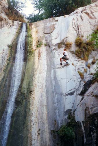
Eventually, you must start downstream again. About 3hrs 30min from the start you will again reach the junction where you entered Fox Canyon and the going remains fairly easy beyond this point all the way to the Lower Falls, reached about 1hr from the junction. The Lower Fox Falls (at 34o18.24'N 118o10.70'W and elevation 2300ft) come upon you quite abruptly just as it seems you are about to emerge into Big Tujunga Canyon. From above they are an impressive, intimidating sight as they plunge 60ft down a vertical cliff into a deep pool. There is virtually no other way around this obstacle but to rappel down the cliff to the left of the falls and into the pool. It seems almost impossible to surmount this obstacle when travelling up from below unless you are an expert rock climber. Fortunately for those descending, there are two large trees about 10ft back from the edge that are ideally placed to serve as anchors. It is a very exciting rappel down the vertical cliff just a few feet from the plunging falls. However, it is necessary to pre-plan your strategy to negotiate the pool at the bottom. When we came this way the pool was well over 6ft deep and we had to swim about 15yds before we could wade. Basically, the first people down unhooked themselves and dropped into the water from a few feet up. I was the last person to descend and, when almost at the water level, I undid the knot at the end of the double rope, tied one end loosely to my harness, and then let the other end slip free, dragging the rope down as I swam and waded. Here it really pays to have all the contents of your pack in watertight bags. You will reach the bottom of the Lower Fox Falls about 5hrs after the start. From the bottom of Lower Fox Falls to the junction with Big Tujunga Canyon (34o18.11'N 118o10.60'W) takes only about 10min. Here you are near the upstream limit of the lake behind the dam and the floor of the big canyon consists of gravel flats. You also have a choice at this point.
 | 
| |
|---|---|---|
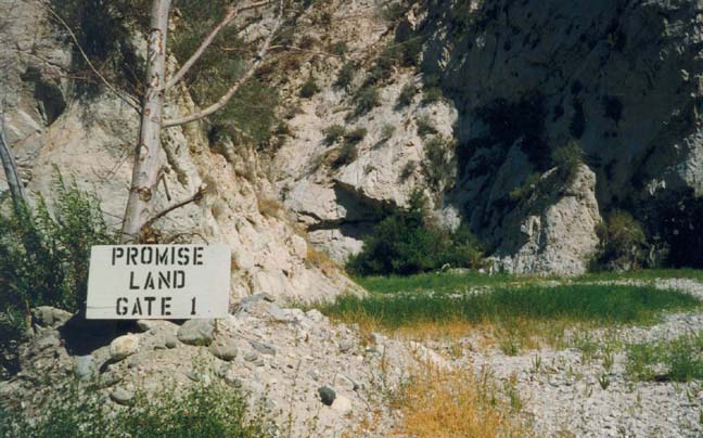
| Lower falls in Fox Canyon | Enigmatic sign in Big Tujunga |
Choice one, the longer but easier route, is to turn left and hike up the canyon. Round one long right hand curve you reach the part of the canyon bottom that you looked down upon at the start of the day. You also encounter a most enigmatic sign, black paint on a white board that reads ``Promise Land. Gate 1.'' Is it a joke or a celestial warning? I will admit I checked to see whether my feet were still on the ground before I continued. However, you really have no alternative but to press on past this ominous sign. Just beyond is the end of the gravel flats. Here is an interesting feature on the right wall of the canyon, a large pool in an overhang or cave where the river appears to be cutting a tunnel through the rockface. A 50min hike upstream from this point will take you back to the point where the fire road crosses the river. This is a pleasant hike through an attractive canyon with a substantial stream. There are many large pools and streamside meadows but also a number of places where there is little alternative but to wade. About 10min before you reach the road you will pass below the 50ft waterfall by which Fall Creek enters the Big Tujunga. The hike back up the road to the parking area takes about 50min or about 2hrs from the bottom of Lower Fox Falls. Take a few moments as you go to look back again at the rugged country of the Fox Canyon watershed for it is truly one of the jewels of the San Gabriels.
Choice two after exiting Fox Canyon is to find a steep use-trail
that climbs from the gravel flats up to the road above. Turn left
after leaving Fox Canyon and proceed about 300yds up Big Tujunga
Canyon. As the canyon makes a right turn you, stay beside the right wall
and find a place in the entrance to a side canyon
(at 34o18.02'N 118o10.41'W)
where a rough
trail climbs up a steep outcropping. A short way up this becomes a
good trail that switchbacks up the canyon wall to the Big Tujunga
Canyon Road. This trail is variously known at the Big Tujunga Canyon
Trail or, in more recent times as the Josephine Trail.
It is then an easy 0.5mi walk up the road to the
parking lot where you started. By this route, it takes about 1hr
to climb from the gravel flats to the parking lot, a saving of about
1hr in time.
Last updated 7/30/99.
Christopher E. Brennen