ADVENTURE HIKES AND CANYONEERING
IN THE SAN GABRIELS
© Christopher Earls Brennen

|
|---|

|
Hike G7. Lookout Mountain
- Hiking time: 8 hours
- Estimated hiking distance: 8.4 miles
- Elevation gain: 2550 feet
- USGS Topo Maps: Mount San Antonio, Mount Baldy
- Difficulties: Navigation
- Special equipment: GPS, topo map
Characteristics
During his distinguished scientific and academic career Albert Michelson, America’s first Nobel Laureate, made some of the most important measurements of the speed of light. Starting about 1920, Michelson began planning a definitive measurement from the Mount Wilson Observatory using a baseline to Lookout Mountain, a prominent bump on the south ridge of Mount San Antonio, some 22 miles away. The measurements used mirrors on the summits of Mount Wilson and Lookout Mountain.
In 1922, the U.S. Coast and Geodetic Survey began two years of painstaking measurement of the baseline. When this was established in 1924, the experiments were carried out over the next two years led to a published value for the speed of light of 299,796±4 km/s. Famous as the measurement is, it was beset by problems, not least of which was the haze created by the smoke from forest fires which blurred the mirror image. It is also probable that the intensively detailed work of the Geodetic Survey, with an estimated error of less than one part in 1 million, was compromised by a shift in the baseline arising from the Santa Barbara earthquake of 29 June 1925 (magnitude 6.3).
This non-technical adventure follows the trail that Michelson and his aides used to reach the summit of Lookout Mountain. The route consists of an unmaintained trail through a pristine canyon and rugged sections of the Sheep Mountain Wilderness where you could encounter Nelson bighorn sheep. It was built originally to access a USFS lookout on Lookout Mountain but was abandoned in the 1930s. It does not appear on current USGS topographical maps. Today it is a strenuous 10-mile hike up through the West Fork of Bear Creek, a nearly pristine riparian area above Mount Baldy Village. To reach the summit of Lookout Mountain you first follow the Baldy Trail (the original miners’ trail to the summit of Mount San Antonio) from Mount Baldy Village to a small meadow known as Bear Flat. From Bear Flat you follow an unmaintained trail which originally led to a USFS lookout on Lookout Mountain. My thanks to Wayne Steinmetz who showed me this trail to Lookout Mountain.
Trailhead
Drive up Baldy Road to Mount Baldy Village. In the center of the village on the left and just before the Forest Service Visitor Center there is a parking lot where you should leave your vehicle.
Hike
From the parking lot in Mount Baldy village (elevation 4267ft and coordinates 34o14.27'N 117o39.47'W), hike up the steep paved Bear Canyon road past the Community Church and various dwellings to the end of the pavement. Here you cross the stream and start up the maintained Bear Canyon trail. It switchbacks up the right side of the canyon and you should take the right fork at one or two junctions. About 1hr and 1.6mi from the start you will arrive at Bear Flats (5470ft and 34o14.83'N 117o39.27'W). Here the maintained trail crosses over to the left side of the stream and on the other side of the stream is a sloping, grassy area that constitutes Bear Flat though at other times of the year it is covered in ferns. There should be a trail marker just on the other side of the stream.
 | 
| |
|---|---|---|
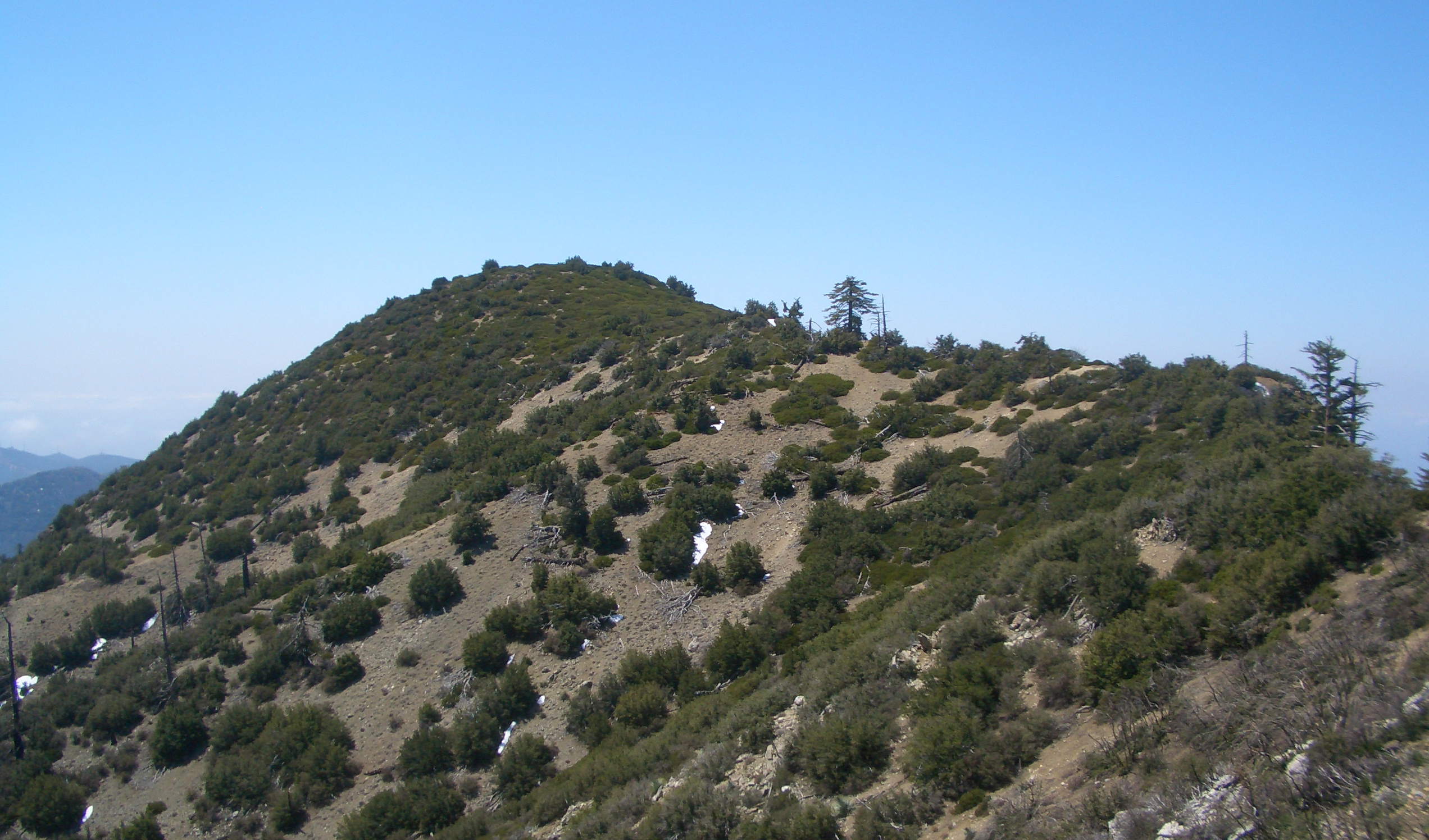
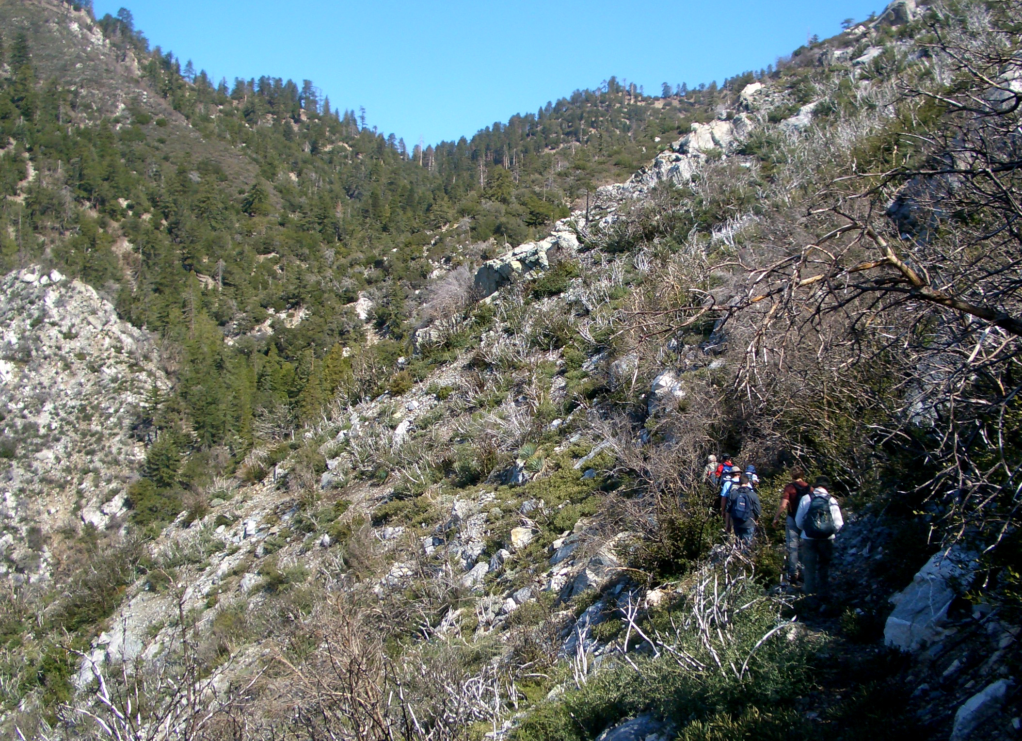
| Summit of Lookout Mountain from ridge trail | Contouring into West Fork of Bear Creek |
Here you leave the maintained trail that proceeds on to the summit of Mount Baldy. Instead you need to search for a faint trail that branches off to the left just beyond the stream and proceeds to the left of the trail sign. After it enters the bushes and crosses through a small wooded draw it becomes easier to follow as it contours upwards around a bluff. Prior to the 1930s this was a maintained trail that eventually led up to the Fire Lookout Station on Lookout Mountain. As it continues to climb and contour around the bluff it is clear that some effort was required to cut this trail into the steep rock slopes. Eventually as you leave the open slopes of the broad ridge and descend slightly into the West Fork of Bear Creek you will pass the remains of an old wooden gate put here to form a corral for the horses used at the trail camp further up the canyon. The surroundings now become heavily wooded and, about 2hrs from the start you descend to the side of the perennial stream that flows through the West Fork of Bear Creek. Here there are some very pretty cascades and pools that are delightful on a hot day. As it continues up the right side of the canyon the trail becomes fainter and more difficult to follow. It is best if you can follow it where it switchbacks in several places for the going is easier and a little faster on the trail. If you lose it just proceed up the right side of the stream bed and you will reconnect with the now quite faint trail.
About 2.5hrs and 2.8mi from the morning start at an elevation of 6020ft and 34o15.39'N 117o39.99'W you should arrive at a fork in the canyon that is important to identify for here you must cross over the small stream and proceed up the left fork. About 15min later at 6200 you may cross the stream again and continue up the draw that is rapidly becoming more open and shallow so the going is easier. There is almost no trail here but you simply continue up, veering left as you ascend the last few hundred feet over open ground to the ridgetop overhead.
|
|---|
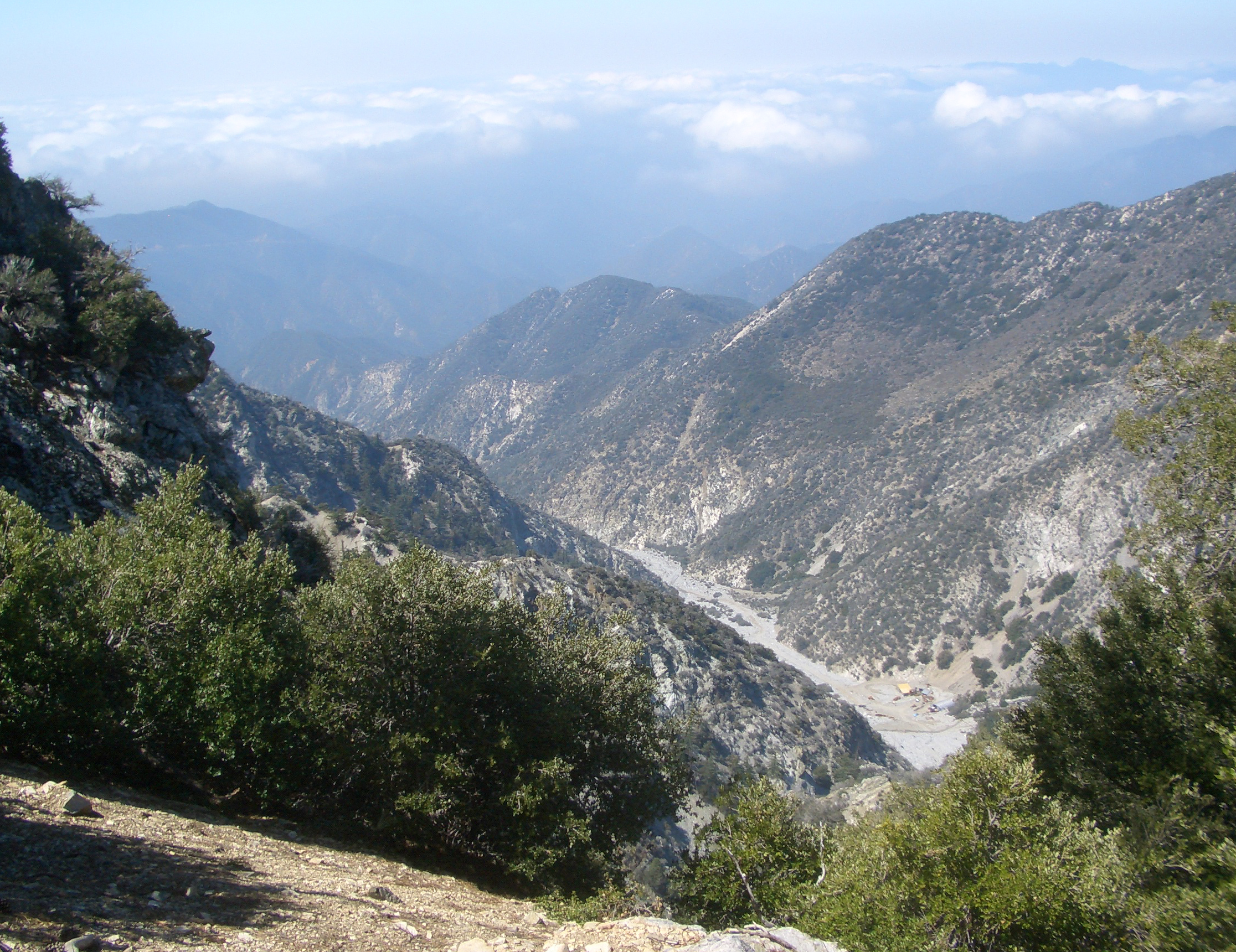
| Cattle Canyon from the ridge top |
You should reach the ridgetop about 3hrs 15min and 3.1mi after the morning start. Here at 34o15.51'N 117o40.23'W and an elevation of 6520ft you are welcomed by a spectacular, almost vertical view to the west down into Cattle Canyon some 2000ft below. The awesome side canyon walls below fall away dramatically toward the gravel bottomed canyon far below. The vertical canyon leading down to it would be a spectacular canyon descent with many huge rappels! Directly below you can see the workings of the Andrew Tungsten Mine (34o15.38'N 117o41.00'W and 4720ft). The owner, a man called Ron Curtis, has claimed that he could make millions from this mine if it were not for the Forest Service and the conservationists. His father staked out the 1500-acre tungsten claim in the 1950s, before the canyon was included in the Sheep Mountain Wilderness Area. It remains to be seen how the dispute between the Federal Government and Ron Curtis will end; meanwhile the workers commute each day down the rough road from Cow Canyon Saddle and up Cattle Canyon to the mine.
From this ridgetop viewpoint you continue left climbing along the apex of the ridge for a few hundred yards until you can see the trail that begins to leave the apex to countour to the south around several intermediate peaks, one labelled 6930ft on the topo map. This contouring trail continues until you come to a shallow saddle in the ridgetop at about 6630ft at which time the top of Lookout Mountain is clearly visible ahead of you. The trail leads through the low Manzanita bushes to the broad, open summit of Lookout Mountain. You should reach the summit at 6817ft and 34o14.93'N 117o40.51'W about 4hrs 15min and 4.2mi from the morning start.
Various scattered artifacts are all that remain of Michaelson's famous experiment and the fire lookout tower that once adorned this summit. Looking in a southwest direction you can see the summit of Mount Wilson where the other part of Michaelson's device was located. However, the views in all directions are spectacular. Mount Baldy looms high above you to the northeast and you can follow San Antonio ridge as it proceeds west from Baldy to Iron Mountain along the way proceeding through several notches including the notorious Gunsight Notch. Off to the east you can look up Icehouse Canyon and Telegraph Peak. Directly across to the east lies the impressive ridge on the east side of San Antonio Canyon with its highest peak, Ontario Peak.
The return hike follows the same route as the ascent and takes about 3.5hrs. There are two important waypoints. First it is clearly important to begin your descent from the ridgetop at the same point at which you ascended to it. Later it is important to make sure and find the trail as it leaves the bottom of the West Fork and begins the traverse across the bluff to Bear Flat. This begins with a gradual climb out of the deeply wooded bottom of Bear Flat at a place just after the stretch with small cascades and nice pools. Once past the remains of the old wooden gate it is easy to follow the unmaintained trail the rest of the way.
The adventure takes a total of 8.5hrs during which you cover about
8.4mi.
Last updated 10/4/10.
Christopher E. Brennen