ADVENTURE HIKES AND CANYONEERING
IN THE SAN GABRIELS
© Christopher Earls Brennen

|
|---|

|
Hike B17. Lower Lucas Creek
- Hiking time: 3.5 hours
- Estimated hiking distance: 4.4 miles
- Elevation gain: 900 feet
- USGS Topo Maps: Condor Peak
- Difficulties: Steep chute downclimb, 25ft and 20ft rappels
- Special equipment: 120ft rope, harnesses, 8ft webbing and two rappel rings
-
ACA Rating: 3A II

Characteristics
Lucas Creek originates on the northwestern slopes of Strawberry Peak and travels northwest to join the Big Tujunga. A descent of the upper section is described elsewhere in the hike of Upper Lucas Creek. Here we described a hike down the lower half of Lucas Creek, from the Angeles Forest Highway to the Big Tujunga. The canyon of Lucas Creek is a moderate sized, north slope canyon, wooded and relatively brush-free though there is some poison ivy in this lower section. It is a fairly easy and short adventure hike that has a little downclimbing and a modest technical hurdle, two rappels of 25ft and 20ft just where Lucas Creek enters the Big Tujunga. It is good hike for the spring when some water is flowing over the falls.
Trailhead
This hike requires either a 1.7mi hike back along the road at the end or a short car shuttle to cover that section. From La Canada/Flintridge drive up the Angeles Crest Highway and turn right at the Clear Creek junction onto the Angeles Forest Highway. When you pass the junction with the Big Tujunga Canyon Road take note of the odometer and drive just over 1.0mi to where the Angeles Forest Highway crosses Lucas Creek (at 34o17.92'N 118o8.91'W and elevation 3040ft). Park in the dirt parking area on the right.
If you wish to cut out the 1.7mi road hike at the end, then first turn left at the junction of the Angeles Forest Highway and Big Tujunga Canyon Road and drive 0.6mi down the latter to a dirt parking area on the right where there is a metal gate across the fire road (at 34o17.82'N 118o10.20'W and elevation 3090ft). Leave the return vehicle there before driving back to the Angeles Forest Highway and proceeding to the start of the hike as described above.
Hike
The drop in from the Angeles Forest Highway (at 34o17.92'N 118o8.91'W and elevation 3040ft) to the lower section of Lucas Creek is not immediately obvious since there is much brush below the highway opposite the parking area. The best route is to hike 100yds back up the Angeles Forest Highway (going south) to where you will find a steep, brush-free scree slope dropping into the canyon. Descend this all the way to the stream. From there, the descent alongside the stream is easy going though there may be brush and poison oak in places. After about 30min you come to two pretty little waterfalls that are readily descended (elevation 2760ft) and shortly thereafter a large gully enters on the left.
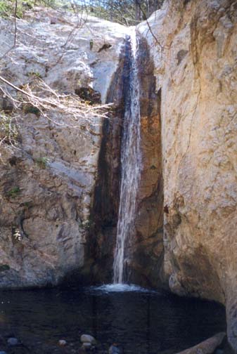
|
|---|
| Lower Lucas Creek Falls |
The first significant obstacle occurs after about 1hr at an elevation of 2560ft and at a point where the canyon narrows. Here there are several small waterfalls and two canyon-spanning pools. It is relatively easy to climb around these obstacles, going to the right around the first pool and to the left around the second.
After about 1hr 30min at an elevation of 2490ft you encounter the only technical obstacle in this hike, a pretty pair of waterfalls at the very end of Lucas Creek. From the top you can see Mill Creek and the Big Tujunga. Both rappels have trees about 20ft back from the lip that serve as very secure anchors. The upper waterfall is a 25ft vertical drop into a knee-deep pool. Here it is best to stay to the left of the water stream. The second waterfall follows immediately and is a 20ft vertical drop into a thigh-deep pool. Here it is not easy to avoid the falling water.
You will thus reach the Big Tujunga
(at 34o18.36'N 118o9.42'W and
elevation 2380ft) about
2hrs from the start having covered about 0.85mi. Turning left it is but
a short walk with some boulder-hopping before you will encounter the
Mill Creek/Mount Gleason Fire Road where it crosses Mill Creek
(at 34o18.31'N 118o9.61'W). In 2003
the fire road was not easy to recognize because of many years of erosion.
But it should be easy to find where it climbs the left wall of the canyon.
The hike up the fire road to the trailhead on Big Tujunga Canyon Road
(34o17.82'N 118o10.20'W and
elevation 3090ft) is
about 1.7mi and should take about 45min. The hike length
to this point is 3hr and 2.7mi. The hike back along the
road adds about 30min.
Last updated 3/20/03.
Christopher E. Brennen