ADVENTURE HIKES AND CANYONEERING
IN THE SAN GABRIELS
© Christopher Earls Brennen

|
|---|

|
Hike B19. Katharine Canyon
- Hiking time: 6 hours
- Estimated hiking distance: 6 miles
- Elevation gain: 1320 feet
- USGS Topo Maps: Condor Peak
- Difficulties: Two modest rappels of 35ft and 25ft, some downclimbing.
- Special equipment: Helmet, harness and rappeling gear; 160ft rope, 20ft webbing and two rappel rings.
-
ACA Rating: 3A III

Characteristics
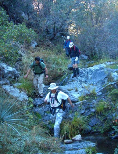
Katharine is the canyon just east of Lucas Creek; it parallels Lucas as it drops down off Strawberry Peak, flowing northwest to join the Big Tujunga just north of the big road bridge and just south of Hidden Springs. A sweet little canyon (much like those it is named after) it is shady, bucolic and relatively brush-free like most of the north facing canyons. Though containing many small and moderate downclimbs, there are only two rappels and one of these can probably be avoided. A small stream flows most of the year providing sustenance to the abundant plant and animal life. Bear tracks and scat are evident everywhere. The canyon could be descended almost anytime of the year though the fall colors in Big Tujunga make that time a special delight.
Trailhead
This hike requires a car shuttle. From La Canada/Flintridge drive up the Angeles Crest Highway and turn right at the Clear Creek junction onto the Angeles Forest Highway. When you pass the junction with the Big Tujunga Canyon Road take note of the odometer and drive 2.7mi to the road bridge over the Big Tujunga. Park one vehicle in the pullout on west side of the road just past the bridge (at 34o18.72'N 118o8.26'W and elevation 2830ft). While there examine the climb out of Big Tujunga that you will need to make at the end of this hike. Fix in your mind several landmarks that will help in finding the best route for this ascent; there is a scree slope about 150yds north of the bridge that provides one such route. Then drive back to Clear Creek junction in the other vehicle(s). Park in one of the pullouts surrounding this junction (at 34o16.22'N 118o9.19'W and elevation 3655ft).
Hike
The Josephine Fire Road begins on the east side of Angeles Forest Highway just about 100yds from the intersection with the Angeles Crest Highway at an elevation of 3650ft. Pass the metal gate and hike up this well-used dirt road as it climbs steadily toward the ridge between Josephine and Strawberry Peaks. When, after 1hr 10min and 2.4mi of hiking, you come to the ridge (at 34o16.95'N 118o8.52'W and elevation 4890ft) you are treated to spectacular views both to the south and the north. To the south you can see downtown Los Angeles and beyond, the Pacific Ocean, the Palos Verdes peninsula and Catalina Island. In the other direction, the northern San Gabriel mountains are spread out before you. You are looking up the valley of Mill Creek toward the saddle where the highway begins its descent toward Palmdale. To the left of that is Mount Gleason and you can see the Fall Creek/Mount Gleason fire road wind its way up the long ridge toward that summit.
 | 
| |
|---|---|---|
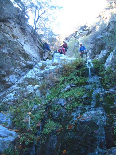
| Descending Katharine Canyon (Photo by Ira Lewis) | Last rappel |
Turn right and follow the trail eastwards along the ridge for about 0.5mi to Josephine Saddle (34o16.92'N 118o8.05'W and elevation 4850ft), readily identified by the large circular water tank. You should reach this point about 1hr 20min from the start. Directly below you on the north side is the canyon of Lucas Creek which is described elsewhere in this collection.
From Josephine Saddle follow the trail northeastwards as it gently climbs and contours around the north side of Strawberry Peak and around the head of several of the forks of Lucas Creek. All of these forks are clearly part of the same watershed that leads down to the visible Angeles Forest Highway. The trail climbs gently over the ridge into the next watershed and just after it does, about 1.0mi or 25min from Josephine Saddle, it drops a short way to contour through a streambed (at 34o17.46'N 118o7.79'W and elevation 4945ft); this is Katharine Canyon and here you leave the trail to begin the descent. You should reach this drop-in point about 1hr 45min from the start having covered about 3.9mi.
The upper section of Katharine Canyon makes for relatively easy descent with little brush and lots of rough, exposed bedrock. About 45min after the drop-in, you will come to the first downclimb at an elevation of about 4510ft, a 15ft drop climbed down on the canyon left. About 10min later there is another, larger (30ft) sloping downclimb in mid-canyon and this is followed about 35min later by another 30ft downclimb where the best route is via a slot on the left. The canyon is wooded throughout its length and gets more lush as you descend. Running water will be encountered most years around the mid-point of the descent and helps sustain not only the foliage but also a clearly evident animal population. Signs of bear are everywhere.
|
|---|
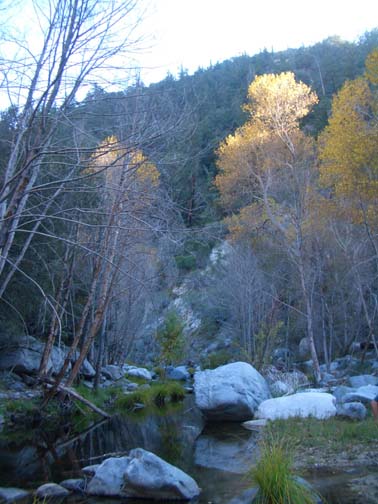
| Fall color in Big Tujunga |
About 3.5hrs from the morning start at an elevation of around 3900ft you will come to the first rappel, a 40ft wooded drop where a steep gully tributary comes in on the left. You can rappel down the stepped watercourse or you can climb around to the left onto the nose of the junction and descend there using one of several tree anchors. It is probably also possible to downclimb by contouring just a little further left into the steep gully and descending there. An hour later there are several downclimbs in a narrow, twisting section of canyon. Another hour later you will come to the second and last rappel, a 25ft drop from a small tree anchor on the right. Just a few yards beyond these falls, Katharine Canyon ends at the Big Tujunga at 34o18.58'N 118o8.10'W and an elevation of 2735ft. You should reach the Big Tujunga 5.5hrs after the morning start having covered about 5.6mi.
This is a lovely, boulder-strewn section of the Big Tujunga, particularly
enjoyable in the fall with its pools and colors. Turn right and proceed
downstream and after a big left turn you should see the Angeles Forest
Highway ahead of you, high up on the canyon wall. Below the highway the canyon
makes a left turn but, well before that turn, you need to find a route
through the bushes on the right that leads to the bottom of a steep scree
slope
(at about 34o18.67'N 118o8.22'W and
elevation 2760ft).
Ascending that scree slope brings you to the highway, hopefully close to
where you parked the return vehicle
at 34o18.72'N 118o8.26'W and
an elevation of 2830ft.
The hike takes about 6hrs during which you cover about 6mi.
Last updated 11/20/05.
Christopher E. Brennen