ADVENTURE HIKES AND CANYONEERING
IN THE SAN GABRIELS
© Christopher Earls Brennen

|
|---|

|
Hike K1. Hall Beckley Canyon
- Hiking time: 7 hours
- Estimated hiking distance: 4 miles
- Elevation gain: 1340 feet
- USGS Topo Maps: Pasadena, Condor Peak
- Difficulties: Eight rappels up to 140ft, some downclimbing.
- Special equipment: Helmet, harness and rappeling gear; 160ft rope, 160ft recovery cord, 60ft webbing and eight rappel rings.
-
ACA Rating: 3B III

Characteristics
Hall Beckley Canyon drops steeply down the south face of Mount Lukens into La Canada/Flintridge. It is a moderately challenging, quite brush-free canyon with several big rappels and lots of small downclimbs. Water runs in its lower reaches most of the year but there are no substantial pools to negotiate so only your feet will get wet. It is best for the winter, spring or fall; in the summer the hike up to the head of the canyon is very hot.
Trailhead
This hike requires a car shuttle. From the junction of Foothill Boulevard and the Angeles Crest Highway in La Canada/Flintridge drive west on Foothill and turn right (north) onto Palm Drive. Continue past Palm Crest School on the left. Just beyond this school and the stop sign that follows, Palm Drive begins to meander and you should park a recovery vehicle just a couple of hundred yards from the stop sign and close to Number 5147, Palm Drive.
Then, in the other vehicles, drive back down Palm Drive to Foothill Boulevard, turn left on Foothill and left again onto Angeles Crest Highway. Proceed up the Angeles Crest Highway to the Ranger Station. Take note of the odometer and drive another 2.4mi to where there is a small turnout on the left just after a sharp corner. This is the Dark Canyon trailhead though the trail is hard to spot when you are driving. A big sign on the other side of the road recounts the fire restrictions and a mile marker reads ``30.02'' vertically.
Parenthetically we note that many of canyons that descend the slopes of Mount Lukens, including Silver, Suicide, Sutton and Hall Beckley, have three alternative approach routes, all of which provide access to the upper reaches of the Mount Lukens road. The first of these, included in the descriptions of the Silver and Suicide Canyon descents, starts on the Angeles Crest Highway at the 2N79 trailhead at 34o15.62'N 118o11.54'W and an elevation of 2940ft. The second, included in the description of Hall Beckley Canyon, also begins on the Angeles Crest Highway but at the trailhead for the Dark Canyon trail at 34o15.35'N 118o11.81'W and an elevation of 2730ft. The third, included in the description of Sutton Canyon, begins in Deukmejian Wilderness Park at 34o14.98'N 118o15.18'W and an elevation of 2335ft. The elevation gains up to the intersection of 2N76B and the Mount Lukens road (at 34o15.81'N 118o13.74'W, near the drop in for Silver Canyon) are respectively 1680ft, 1890ft and 2285ft; however the distances are respectively 5.4mi, 3.3mi and 2.8mi. The hiker can choose whether he or she would rather hike a longer distance or a greater elevation gain.
Hike
Directly behind the parking area (34o15.35'N 118o11.81'W and elevation 2730ft) the Dark Canyon trail switchbacks up through the trees, climbing steeply up to a wooded plantation area. Here you come to a dirt road that encirlces the trees; turn right or left to follow the road around the plantation and then continue up to its junction with the Grizzly Flats Road at 34o15.66'N 118o12.16'W, an elevation of 3310ft and 0.66mi from the start. This is a major fire road junction; a short distance to the west there is a fork where the right branch descends to Grizzly Flats. For the present hike you have two options here. You can take the fire road that goes west, fork left at the split and proceed on up the road toward the Mount Lukens Fire Road. That is the long but relatively easy option. The short but steep option is to follow the rough firebreak trail that proceeds ESE from the junction and climbs the ridge up to a point at 34o15.55'N 118o12.35'W and an elevation of 3770ft where the trail rejoins the fireroad. We took the second option and rejoined the fireroad 1hr and 0.9mi from the start.
 | 
| |
|---|---|---|
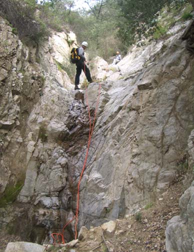
| The 80ft third rappel | The 140ft seventh rappel |
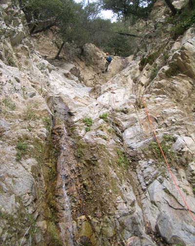
Proceed south along the road to the junction with the Mount Lukens fire road (34o15.09'N 118o12.45'W and elevation 4020ft). Here along the top of a major ridge you get great views of the San Gabriels to the west and to the east. Continue south on the Mount Lukens fire road as it broaches a small summit and begins to descend. Once you see a large watertank directly ahead of you, look for the road junction at 34o14.71'N 118o12.20'W and an elevation of 3800ft. Here you are looking directly down into the head of Hall Beckley Canyon. Fork right and proceed about 200yds around the head of one Hall Beckley branch and then part way around the head of a second (and major) branch. Here you should readily discern the best drop in point for Hall Beckley Canyon at 34o14.72'N 118o12.29'W and an elevation of 3720ft. It should take about 1hr 40min to reach this point, 2.2mi from the start. The drop-in is a steep, sandy brush-free wash that leads down from the road into the head of the canyon. After about 30min of steep but easy descent, a large gully comes in on the right (at about 3450ft) and 10min later you arrive at the first, small rappel of 20ft, anchored by a small bush on the left. Shortly thereafter there are a series of downclimbs beginning with a 30ft drop at 3240ft followed by several smaller downclimbs.
At an elevation of about 3040ft and 2hrs 45min from the start you will arrive at the second rappel, a 30ft drop from a bush anchor to the right side of the lip. Then 15min later you enter a more heavily wooded area where a large canyon comes in on the left at 34o14.46'N 118o12.35'W and an elevation of 2930ft. The going is fairly easy for the next 25min until you abruptly arrive at the first of the big rappels, an 80ft inclined two-step drop from a bush anchor just to the right of the lip. This is immediately followed by another 80ft steep rappel for which a tree on the left provides a solid anchor. You should reach the bottom of this rappel about 3hrs after the morning start. Downstream of these rappels a large gully enters on the right at 34o14.32'N 118o12.45'W and an elevation of 2700ft. Another short distance downstream there is a small 20ft rappel for which it is necessary to climb up to the tree on the right to acquire a solid anchor. This leads to several downclimbs and, about 20min later, to a small, two-step rappel from a bush anchor on the left side.
About 15min later, 5hrs 10min from the morning start at an elevation of about 2680ft, you will abruptly come to the top of the biggest rappel in Hall Beckley Canyon, a 140ft five step drop in a narrow slot (narrow by San Gabriel standards). Using the anchor around the small tree some distance up on the right side, you descend steps of 80ft, 27ft, 15ft, 6ft and 12ft beside what is normally a small water flow. The final rappel is a short way downcanyon and consists of two small steps of 10ft and 6ft for which there is no good anchor; we used a skimpy root on the right and practised a combination downclimb/rappel. The water company installations begin just downstream of these rappels. On the left side a tunnel runs about 80ft into the canyon wall in order to tap the water there and pipes run from here down to the end of the canyon. About 15min below this point a large canyon enters on the left at 34o14.10'N 118o12.47'W and an elevation of 2370ft. There are two small vertical drops just a few yards up this canyon from the junction. You should reach this junction about 6hrs 15min after the morning start having travelled about 3mi.
Downstream of this junction the water company has installed some rudimentary
wire cables at a number of small drops but you should use gloves if you utilize
those cables. Otherwise it is a fairly straighforward hike down the canyon
from the last junction and after about 30min you come to the first
human construction, a small flood control dam which has a convenient
ladder to ease descent.
From there, you continue near the streambed past a couple of houses on the
right side. Beyond these do not take the dirt road that climbs out of the
canyon on the left. Instead continue down another flood control dam and
then transition up to the road on the right side that proceeds down the
canyon. When you come to two forks proceed left at both. After the second
the road crosses the stream and 100yds later comes to the gate
across the road just beside where your recovery vehicle should be
parked near #5147 Palm Drive at
34o13.47'N 118o13.00'W and an
elevation of 1820ft. The duration of the hike should be about
7hrs during which you cover about 4mi.
Last updated 2/24/06.
Christopher E. Brennen