ADVENTURE HIKES AND CANYONEERING
IN THE SAN GABRIELS
© Christopher Earls Brennen

|
|---|

|
Hike H1. Falling Rock Canyon
- Hiking time: 8 hours
- Estimated hiking distance: 7.7 miles
- Elevation gain: 3800 feet
- USGS Topo Maps: Cucamonga Peak, Mt. Baldy
- Difficulties: Much bouldering
- Special equipment: None
-
ACA Rating: 2A III

Characteristics
Icehouse Canyon is one of the most attractive and popular hikes in the San Gabriel mountains. Each weekend, at almost any season of the year, you will encounter others enjoying the beautiful stream, the many sparkling pools and the mature pine trees for which Icehouse Canyon is justly famous. Many hikers follow the well-trodden trail all the way up to Icehouse Saddle and some even venture beyond to conquer one of the three peaks on the rim to the south (Cucamonga Peak, Bighorn Peak and Ontario Peak) or one of the other row of peaks to the north (including Timber Mountain and Telegraph Peak). Few venture off the trails in this rugged and precipitous high country.
But the rim to the south provides several spectacular canyoneering adventures for those who are so inclined and this book features two adventures in canyons that drop down Icehouse Canyon's precipitous southern wall. One of these, Sheep Canyon, features a spectacular 260ft drop and is, perhaps, the most technically challenging descent in this whole book. The other, Falling Rock Canyon, is the subject of this adventure; it is relatively easy and can be descended without technical equipment. It is also a beautiful hike, ideal for the late spring or fall. In the summer, the climb can be very hot. In the winter and early spring, the snow lying at the higher elevations makes it much more difficult.
Trailhead
The trailhead for this hike is the Icehouse Canyon parking area (34o15.00'N 117o38.11'W, elevation 4990ft), 1.5mi north of Mount Baldy Village in San Antonio Canyon. The access road to this parking area proceeds straight on at a fork where the road continuing up to the ski lift makes a sharp left turn.
Hike
From the parking area (elevation 4990ft), proceed up the well-marked Icehouse Canyon trail that parallels a sparkling, year-long stream. There are many cabins in the first mile or so, and also ruins of cabins that were destroyed by a flash flood in 1938. As you progress along the first mile, take a few moments to glance up at the cliffs on the right or south side of the canyon. The high peak directly to the south is Sugarloaf Peak (6924ft) but it seems almost inaccessible from this vantage point. Initially the cliffs on the south side are almost unbroken and so it is quite simple to identify the first real side canyon (34o14.92'N 117o37.73'W, elevation 5260ft), that has its entrance just under a mile from the start. This is Falling Rock Canyon by which we shall make our descent. If you look closely you will be able to discern a faint use-trail that branches off to the right from the main trail just before a large ruin. This use-trail proceeds up Falling Rock Canyon.
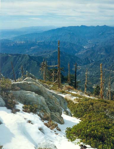 | 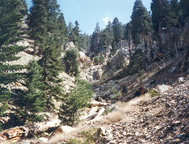
| |
|---|---|---|
| View West from Ontario Peak | Falling Rock Canyon below waterfall |
Continuing up the main trail, the cabins and the incense cedars soon disappear and you enter the Cucamonga Wilderness as the landscape becomes more rugged and open. The trail steepens as it switchbacks up the north slope of the canyon and 3.5mi and 2hr from the start you finally reach Icehouse Saddle (34o14.35'N 117o35.66'W, elevation 7550ft). Several trails come together at this point but you should identify the trail to Kelly's Camp and Ontario Peak. This doubles back along the south side of Icehouse Canyon, travelling in a westward direction. It rises gently as it traverses the wooded northern flank of Bighorn Peak and, after 0.7mi, arrives at the former site of Kelly's Camp (34o14.03'N 117o36.33'W, elevation 7840ft), marked only by a group of cabin foundations. This is a favorite camping site as you can tell from the remains of several fireplaces. The trail then switchbacks up to the top of a long east-west ridge that you follow all the way to its end at Ontario Peak (34o13.66'N 117o37.45'W, elevation 8693ft), some 2.3mi and 2hr from Icehouse Saddle. On a clear day the view from this rocky peak is magnificient. To the south there is a precipitous drop of several thousand feet into Cucamonga Canyon and, in the distance, you may be able to see Catalina Island and, beyond that, San Clemente Island. It is a beautiful place to eat lunch.
After lunch, you should backtrack along the trail for a short distance. As you do so look carefully at the canyons that begin below you to the north of the trail. The canyon directly north of Ontario Peak is Cherry Canyon. Immediately to the east of Cherry Canyon is the canyon you seek, namely Falling Rock Canyon. To make certain that you have chosen the right canyon, locate the ridge between Cherry Canyon and Falling Rock Canyon that begins about 200yds back along the trail from Ontario Peak. This ridge descends slowly and is easy travelling for the first few hundred yards. You will be able to see Cherry Canyon turning to the west and, far below, the area near Mount Baldy Village. On the other hand, Falling Rock Canyon proceeds directly north in the direction of Mount Baldy. Once you have double-checked your navigation, it is easy to transition to the east down into Falling Rock Canyon and begin serious descent. (On one expedition, we misjudged the situation and inadvertently travelled too far east along the trail, dropping into Sheep Canyon by mistake. About 2hrs down canyon we were shocked to encounter the huge 260ft drop of the Sheep Canyon headwall. We were fortunate to find a way to contour along to the west above the cliff and to descend through a small canyon called Fir Draw, some distance to the east of Falling Rock Canyon. For further information please see the Sheep Canyon adventure.)
Falling Rock Canyon soon begins to descend more steeply but the going is fairly easy, particularly along the dirt and rock covered north-east slope of the canyon. After some wandering, the canyon turns northwest and soon the ridge leading to Sugarloaf will become visible ahead of and below you. About 2hr after starting the descent you arrive at the first of two attractive and rocky waterfalls at an elevation of about 6600ft. The first falls had substantial water when we hiked this way early in the summer. But the water disappeared just a short distance downstream. There is a straighforward route around the first falls on the left side. A little further down canyon, you encounter the second and normally dry falls. From above you might be tempted to climb straight down. Do not do so for the rock steepens near the bottom. Instead there is an easy bypass up and over the low ridge to the left and down the scree slope on the far side.
A short distance down the canyon from this second waterfall, at an elevation of about 6000ft, you encounter a large scree slope on the left. This is topped by a ridge and saddle that are only about 600ft above the canyon bottom. A rough use-trail climbs up the loose scree slope to the saddle (34o14.42'N 117o37.79'W, elevation 6690ft). If you are feeling particularly energetic you might like to take a side trip up to this ridge and from there to the summit of Sugarloaf Peak. Your reward for the exhausting climb is a quite spectacular view of Mount Baldy Village and San Antonio Canyon. You can follow the trail along the ridge, proceeding first in a northwesterly direction and then in a southwesterly direction and thus reach the summit of Sugarloaf Peak (6924ft). The climb to the top of Sugarloaf takes about 1hr 15min. The descent is a great deal easier and faster (35min), particularly if you slide back down the scree slope into Falling Rock Canyon.
From this point it takes about 1hr to travel down Falling Rock Canyon to the point where it meets Icehouse Canyon. The going is mostly boulder-hopping though there are some places where some clambering is needed. Toward the end of this descent, it becomes very clear why this chute is called Falling Rock Canyon for the sidewalls are fractured and unstable and the canyon bottom is littered with rockslides. The only significant obstacle is a small, 20ft waterfall near the bottom of the chute. Contour along one of the ledges above and to the right of the falls and you will easily locate one of several use-trails through the bushes that will allow you to continue downhill. After this, the chute broadens into a small boulder field that merges with the bottom of Icehouse Canyon (34o14.92'N 117o37.73'W, elevation 5260ft). After you reach the Icehouse Canyon trail again, it is only about 10min to the parking area at the entrance to Icehouse Canyon (34o15.00'N 117o38.11'W, elevation 4990ft).
Note that this hike could also be done in reverse. Note also that
Falling Rock Canyon could be ascended to access the top of Sheep
Canyon.
Last updated 10/16/01.
Christopher E. Brennen