ADVENTURE HIKES AND CANYONEERING
IN THE SAN GABRIELS
© Christopher Earls Brennen

|
|---|

|
Hike G6. Falling Leaf Canyon
- Hiking time: 7.5 hours plus 45 minutes back along road
- Estimated hiking distance: 2.9 miles plus 1.7 miles back along road
- Elevation gain: 1300 feet
- USGS Topo Maps: Mt. Baldy
- Difficulties: About 6 rappels, one over 150ft, much boulder hopping and one tricky navigational challenge
- Special equipment: 200ft rope, rappelling equipment and 30ft webbing
-
ACA Rating: 3A III

Characteristics
Just west of Mt. Baldy village, a mountain road leads up to the Cow Canyon Saddle and Overlook which provides a spectacular view west into the large region that drains into the San Gabriel River. From this point ridge after ridge of the San Gabriel mountains step away into the distance. In the foreground the deep fissure leading west below you is Cow Canyon as it winds its way toward its meeting with the East Fork of the San Gabriel. Off to your left the Glendora Ridge Road meanders in and out of tributary canyons on its way west. This hike explores a small part of this wilderness. From a point along the Glendora Ridge Road it descends the rugged Falling Leaf Canyon, a descent that involves about 6 rappels and negotiates numerous waterfalls including two large ones measuring about 150ft and 80ft. Eventually you reach the junction with Cow Canyon and trek upstream to a point where there is a steep route of ascent back up to the Glendora Ridge Road. This is a rugged adventure highlighted by the big waterfalls in Falling Leaf Canyon.
Trailhead
From the cities of Claremont or Upland drive north up Mills Avenue or Padua Avenue to Mount Baldy Road. Follow Mount Baldy Road into the mountains (San Antonio Canyon) and, as you enter Mount Baldy Village, turn left onto Glendora Ridge Road. A little under a mile up this road and you will arrive at Cow Canyon Saddle (34o13.69'N 117o40.24'W, elevation 4560ft). Pull into the parking area here to enjoy the view and get your bearings. Then continue another 2.2mi along the Glendora Ridge Road to base of the deep recess cut into the ridge by Falling Leaf Canyon. Leave your vehicle in the small parking area (marked by a trash can) on the south side of the road (34o13.06'N 117o41.89'W, elevation 4400ft). To confirm that you are in the right place look for two old water tanks a short distance up the wooded slope on the south side of the road.
Addendum: At the end of this hike you will climb up to the road at a point about 0.6mi west of Cow Canyon Saddle. There is a dirt pull-out on the north side of the road at this point (34o13.52'N 117o40.70'W, elevation 4460ft). The pull-out is not easily identified but, from the edge of the road, you can see a long way down the steep scree slope that is the ascent route. If you can identify this point you might wish to deposit a bicycle there so that one person can ride back along the road at the end of the hike in order to recover the vehicle. This will avoid the 1.7mi hike back along the road.
Hike
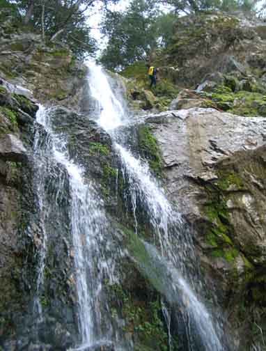
From the parking area (34o13.06'N 117o41.89'W, elevation 4400ft), cross the road and start down the stream bed of Falling Leaf Canyon. Water usually flows the whole length of this canyon. Initially the going is easy in a shady wooded canyon with little brush. Consequently it is quite a surprise when, 45min from the start at an elevation of 4120ft you arrive at a spectacular overlook into a deep cliff-ringed bowl that cannot be seen from higher up. A big waterfall drops vertically about 150ft into the abyss below you. Using the tree on the left at the lip as your anchor, there are two alternative rappeling routes to the bottom of this big waterfall. You can single strand rappel directly down the route of the waterfall, a straight drop of about 150ft. This is a wet rappel but could be fun on a hot day. Or you can opt for the easier, dry route down an old channel on the right. This is best done in two stages, first by double rappelling about a third of the way down to a large tree in the center right of the dry channel, and then double rappelling the rest of the way using this tree as anchor. Whichever route you use, take a moment at the bottom to enjoy this magnificent waterfall that is not marked on the topo map.
 | 
| |
|---|---|---|
| The big waterfall | Second 80ft rappel |
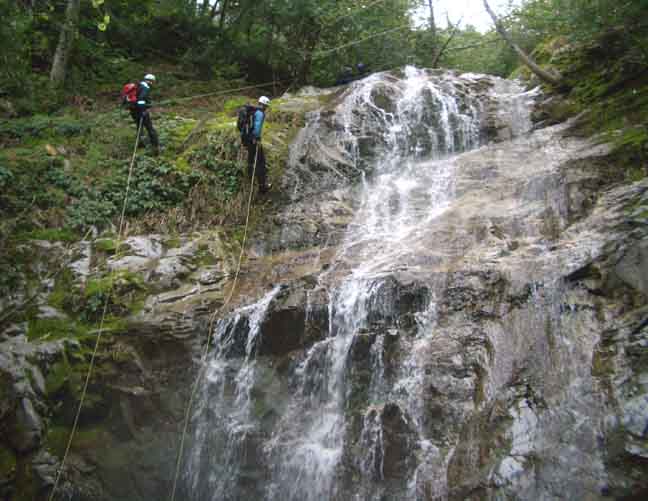
A small cascade immediately follows the big waterfall but this is easily downclimbed on the left side. Then, just a short distance further downstream you will arrive 1hr 30min from start at an elevation of 3950ft at a second large waterfall, an 80ft cascade spilling down a broad steep rock face. Use the small tree on the left for a dry and straightforward descent.
The canyon continues shady and wooded and, 2hr from the start at an elevation of 3700ft, you will come to a pretty 40ft vertical ribbon waterfall. You might chose to rappel using the tree above some rocks on the right. On the other hand once you surmount those rocks you can discern an easy descent trail on the right. A little further downstream (2hr 20min from start at 3540ft), you will encounter a vertical 60ft waterfall. A trail around on the right bypasses these falls via a tributary that enters on the right immediately downstream of the falls. Note the pretty waterfall in this tributary a few yards upstream. Just a short distance downstream, 2hr 30min from the start and at an elevation of 3520ft there is an awkward 15ft waterfall without a safe climbing route on either side. Rappel down using the tree on the right.
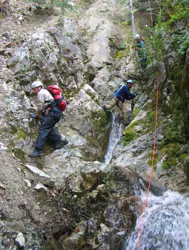
An uneventful section ends at an elevation of 3280ft when, 3hr 20min from the start, you reach the top of an awkward series of small waterfalls in a slot with a blind corner. It is probably possible to proceed down the slot, downclimbing and perhaps rappeling. But since we could not tell what lay around the blind corner we opted for a safer route, climbing up the slope on the right and then contouring about 20yds through the bushes to where the trees stopped. Using one of these trees as anchor we then rappelled down through the branches into the middle of the slot and from there to the bottom of the lowest waterfall, a total descent of about 60ft. Twenty minutes later you will encounter an attractive 50ft ribbon waterfall with a rough descent trail on the left that involves a tricky friction slope descent at one point.
 | 
| |
|---|---|---|
| Third waterfall | Climbing down the chute |
Finally, 4hr from start and at an elevation of 3100ft, you push through some bushes and arrive at the end of Falling Leaf Canyon where it empties into Cow Canyon (34o13.79'N 117o41.98'W, elevation 3100ft). At this point Cow Canyon is broad and open with a substantial stream. Turning right and facing upstream, you start on a long, 2.5hr trek up Cow Canyon to the point (the ``exit point'') where you will climb out and back up to the Glendora Ridge Road. There is almost no use-trail in Cow Canyon and the best route over most of its length is boulder-hopping in the stream itself. Some bush-whacking is needed and in several places and you need to be careful to stay in the main canyon.
As you progress upstream, the canyon gradually narrows and becomes more wooded. Indeed, at one point near the end of the trek, it narrows to a slot filled with a series of small pools. You may need to get your feet wet here. Several hundred yards upstream of these identifiable narrows, look carefully for the markers that identify the exit point. You should reach this important way point (34o13.67'N 117o40.76'W, elevation 3880ft) 6.5hr from start of the hike. Obviously it is very important not to miss the exit point. It occurs in a wooded section and the canyon turns left just upstream of the exit point. It is presently marked by a large, stream-bridging log whose root end projects a few feet into the steep chute on the right. That chute is the start of the exit route. On the other, left side of the stream is a broad wooded bench and several large boulders. I left two ducks, one on either side of the entrance to the chute, one on the root end of the log and the other on a rocky shelf on the right side of the entrance.
Pause here and summon your resources for the steep climb ahead. Then proceed up the initially very steep chute, climbing up onto the earthen slope on the left side in several places in order to bypass a number of small dryfalls. Soon the slope of the gully bed eases a little and allows more continous progress for several hundred yards. But keep a sharp lookout for a large 55 gallon drum embedded in the left bank of the gully. About 30yds downstream of the 55 gallon drum, you should leave the streambed and proceed up a steep scree slope to the left or east of the gully. As you proceed up this slope and emerge from the trees you should find yourself at the bottom of a long and steep, but open scree slope with almost no vegetation. It must have been the track of a major earth slide. Climb straight up this scree slope aimimg first for the shade of a prominent conifer tree several hundred feet above you. Above this tree the slope gets even steeper. There are several ways to reach the road which is only about 100ft above you. I recommend veering right across the top of a small cliff and onto a wooded ridge that provides the easiest ascent to the road.
Finally, 7.5hr from start at
34o13.52'N 117o40.70'W and
an elevation of 4460ft, you arrive
back at Glendora Ridge Road. Turning right (west), it is a
fairly level 1.7mi hike back along the road to the car. If you can
roughly
locate this exit point during your early morning drive to the trailhead
then you could deposit a bicycle here so that the driver can ride
back along the road to the vehicle while the others wait for him or her
to return.
Last updated 5/1/00.
Christopher E. Brennen