ADVENTURE HIKES AND CANYONEERING
IN THE SAN GABRIELS
© Christopher Earls Brennen

|
|---|

|
Hike H4. Middle Cucamonga Canyon
- Hiking time: 4 hours
- Estimated hiking distance: 5.5 miles
- Elevation gain: 800 feet
- USGS Topo Maps: Cucamonga Peak, Mt. Baldy
- Difficulties: Some modest bouldering and some bushwhacking
- Special equipment: None
-
ACA Rating: 2A II

Characteristics
East of San Antonio Canyon a lofty rim consisting of Ontario, Bighorn and Cucamonga Peaks dominates the southern skyline of the San Gabriel Mountains. The peaks form a catchbasin, the run-off from which gets funneled into the wild and rugged Cucamonga Canyon. Because of the difficulty of access this is one of the less well known of the major canyons of the San Gabriels. But, for those with a four-wheel-drive vehicle it makes a spectacular and fairly easy adventure hike with features ranging from a beautiful, shaded canyon with some great swimming pools to rugged waterfalls and rock-ribbed canyon. It is also a hike that is readily adjusted to the available time and energy. Best undertaken during the summer or fall when the river is not swollen with run-off, the canyon can become much more difficult to negotiate during the winter and spring.
Trailhead
The trailheads for this hike are deep in the middle section of Cucamonga canyon. They are reached from the west by driving east on Foothill Boulevard and turning north on Euclid in the city of Upland. Some distance up Euclid you turn right onto 19th Street and then left (north) on Sapphire. At the northern end of Sapphire, turn left on Almond and then immediately right on Skyline. Skyline rapidly narrows to a single lane as it climbs into Cucamonga Canyon. There is a small parking area where the asphalt ends and the dirt road begins. Those without a four wheel drive vehicle would be well advised to park here for the dirt road is often in quite poor condition just a short way beyond this point. You can proceed on foot to the trailhead though this adds about another three miles to the hike.
The dirt road continues to climb for about 0.3mi at which point there is a fork (34o10.49'N 117o37.44'W, elevation 3150ft). Take the left fork that descends again toward the canyon bottom and crosses the river at a concrete ford just before a large clearing where there are many places to park (34o10.86'N 117o37.80'W, elevation 2680ft). If you decided to proceed up the canyon bottom, park here. If you decided to make the round trip via the West Fork Trail then you should drive on past this parking area. The road (in good condition here) climbs to the left up a side canyon; after about 0.5mi you come to a place (34o10.94'N 117o38.13'W, elevation 2930ft) where the road turns left to cross this side creek. Park in the trees at the first clearing you encounter just before this crossing. You should be able to spot the West Fork Trail climbing back up the slope above the last section of road you drove in on. From the asphalt to the trailheads takes about 15min in a vehicle.
Hike
There are two versions of this hike. The round trip version I recommend follows the overgrown West Fork Trail that contours along the west side of Cucamonga Canyon before dropping into the canyon bottom after about 2.3mi. From this point you can proceed up the canyon as far as you wish. On the return I suggest you follow the canyon all the way down to the large parking area described above. You will then have to hike a short way up the road to return to your vehicle. In the second version of the hike, you follow the canyon bottom both coming and going. The disadvantage of the West Fork Trail is that it is very overgrown in places and occasionally difficult to follow; better to wear an old, long sleeved shirt and long pants for this trail. The advantage is that you are treated to quite spectacular views you cannot get from the canyon bottom.
 | 
| |
|---|---|---|
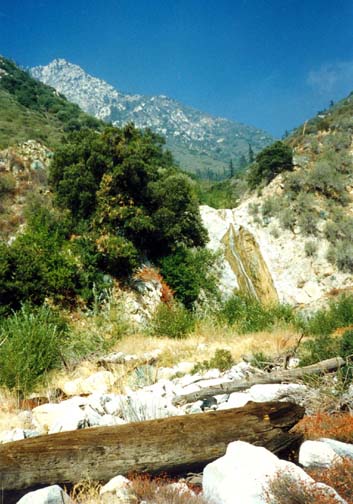
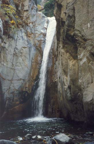
| At top of the boulder field | Lower falls in Cucamonga Canyon |
The West Fork Trail (7W05) starts at 2930ft and climbs steadily as it traverses the western wall of the canyon. As you snake in and out of the gullies in this wall you get increasingly marvellous views of the rugged wilderness between you and the 8500ft rim of mountains to the north. Due north is the 8693ft Ontario Peak that features in another, more advanced adventure hike, Falling Rock Canyon. After about 50min, you arrive at the high point on the West Fork Trail, a small saddle at 3600ft. The brush is particularly thick just before and just after this saddle, but begins to be less obstructive as you descend from the saddle toward the river. It takes about 25min to descend so you reach the river (34o11.56'N 117o37.25'W, elevation 3290ft) about 1hr 15min from the start. In case you wish to return that way, it would be wise to fix in your mind the point where the West Fork Trail reaches the canyon bottom for it could otherwise be difficult to find.
At this point the main canyon widens to form a large and interesting boulder field, about 0.5mi long. As you proceed upstream stay on the left initially but transfer to the right side as you approach the end of the boulder field. Here, about 10min north of the West Fork Trail you pass by a waterfall where a tributary canyon enters on the left. This smaller canyon seems to drop straight down from the precipitous south face of Ontario Peak. A few yards further upstream, the main canyon suddenly closes in and there is a pleasant campsite under the trees on the right. It is only about 15min from here (or 1hr 45min from the start) to the Lower Cucamonga Falls that you encounter rather abruptly after the walls of the canyon steepen and narrow. These falls drop vertically about 50ft from a narrow cleft into a deep pool. They represent the terminus of this hike. However, those with rock-climbing expertize might like to tackle the route around the falls that begins just downstream of the falls and just around the corner on the right or east side. You will find several old ropes hanging down a cliff with many hand and footholds but you should not be tempted to trust your life to such old ropes that are often rotten. Given the right equipment and experience, the climb is fairly straightforward and proceeds as follows. From the top of a small recess, you climb up a series of small ledges and footholds veering to the right and then turn a corner to reach an incline that traverses back to the left. The narrow spine of the ridge is about 100ft above the starting point and a tree just over the other side provides an excellent anchor. It also has a rope that hangs down the other side near a fallen tree trunk that spans the gorge above the main falls. Do not descend via this rope. Instead follow the faint trail up the spine of the ridge for a short distance and, just past a small tree, you will find a much easier trail that descends to the canyon bottom.
Before this descent, take a moment to enjoy the spectacular view from the top of the ridge. Below you the Cucamonga Creek crashes over a whole series of waterfalls as it makes its way through this magnificent gorge. After the descent, you can travel a short distance upstream, climbing over smaller cascades, before encountering another larger waterfall that is difficult to negotiate. But, I emphasize that the climb and the upper canyon are only for the experienced adventure hiker with climbing skill, equipment and experience.
From the bottom of the climb, the return journey involves retracing your steps to the boulder field and the point where the West Fork Trail descends to the canyon bottom. But on the return, I suggest you continue on downstream. It is only about 1.5mi (1hr 30min) from the West Fork Trail junction to the dirt road crossing that marks the end of the canyon transit. Along the way you will encounter several beautiful pools with fish. About 40min below the West Fork Trail junction, there is a particular attractive pool that makes for a delightful summer swim. For almost all the way, the hiking is relatively undemanding though there is some bouldering and many stream crossings. A use-trail becomes more evident as you get closer to the end. This is a beautiful and shady canyon; I travelled this way one lovely fall day and the colors were quite marvellous.
The canyon
is narrowest during the very last stretch and here you encounter the
only significant obstacle in this lower section. Specifically,
about 50min below the West Fork Trail junction you come upon a pool
across the whole width of the canyon. If you feel nimble you can
climb around this pool using a ledge on the left (east) about 6ft
above the water. Otherwise the pool is shallowest (about 3ft deep)
along the right wall. A short distance south of this pool you emerge
in the parking area described as the first trailhead
(34o10.86'N 117o37.80'W,
elevation 2680ft). The time
from the West Fork Trail junction is about 1hr 30min
(or 3hr 45min from the start). If you left your
vehicle at the beginning of the West Fork Trail you must hike up
the dirt road on the right for another 20min or so.
Last updated 7/30/99.
Christopher E. Brennen