ADVENTURE HIKES AND CANYONEERING
IN THE SAN GABRIELS
© Christopher Earls Brennen

|
|---|

|
Hike C1. CCC Canyon
- Hiking time: 6 hours
- Estimated hiking distance: 2.7 miles
- Elevation gain: 800 feet
- USGS Topo Maps: Condor Peak, Pasadena
- Difficulties: About 11 rappels up to 80ft and many small pools, some 5ft deep.
- Special equipment: Helmet, harness and rappeling gear; 160ft rope, 50ft webbing, 5 rappel rings, drybags (and wetsuit in winter).
-
ACA Rating: 3B III

Characteristics
CCC Canyon drops down from the Angeles Crest Highway into the Arroyo Seco just north of the CCC Ridge and has about 11 rappels with one sloping descent of 80ft and the rest smaller than 40ft. There are many chest deep pools to negotiate and some where you can't avoid getting wet. It could be very chilly on a cold winter day so a wet-suit would be advisable under those conditions. Once you exit into the Arroyo Seco it is an easy trail hike down to Oakwilde Picnic Ground and then a steep hike up the Twin Canyon trail to the Angeles Crest Highway.
Though the water in the canyon is not recommended, water is of course available from the Arroyo Seco at the end of CCC Canyon so a filter would be useful especially in summer. This canyon could be descended almost anytime of the year even in summer since it has lots of shade. However, the hike out is very hot in the summer.
Trailhead
This hike benefits from a short and easy car shuttle along the Angeles Crest Highway. First, from La Canada Flintridge drive up the Angeles Crest Highway past the Forest Service Station about 3.4mi from the 210 Freeway. About 1.2mi beyond that Angeles Crest Station you will see a small turn out on the right just before a gentle left hand curve. Park the return vehicle here at 34o14.74'N 118o11.42'W and an elevation of 2610ft). Check that there is indeed a trail that proceeds southeast from this pullout and is headed for electrical pylons in the distance.
Then, in the other vehicle(s), proceed on up the Angeles Crest Highway for another 2.2mi to 34o15.70'N 118o11.30'W at an elevation of 3050ft where there is a large turnout on the left on the outside of a long right turn in the road. Park here.
Hike
From the starting trailhead at 34o15.70'N 118o11.30'W and an elevation of 3050ft cross the road to where there is a broad drop-in slope around the head of CCC Canyon. The easiest route of descent is at the south end and proceeds down past some pine trees where the ground cover is sparse. This takes you down to the streambed where the conduit under the road exits into the canyon bottom. From this point on there is a long open, brush-free stretch of shady canyon interrupted only briefly at 2700ft (30min from the start) by a small 8ft downclimb via tree roots on the left. About 45min from the start at 2660ft you will arrive at the top of the first technical obstacle in the canyon, an 80ft sloping rappel down some slippery steps. The anchor is a tree on the left.
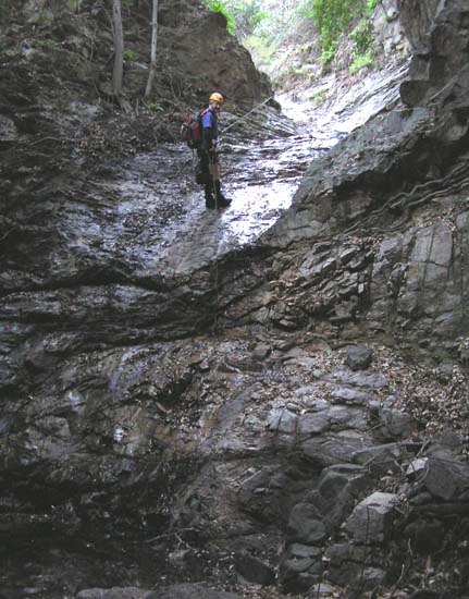 | 
| |
|---|---|---|
| 80ft rappel in CCC Canyon | First deep pool | |
(Photos by Ken King) | ||
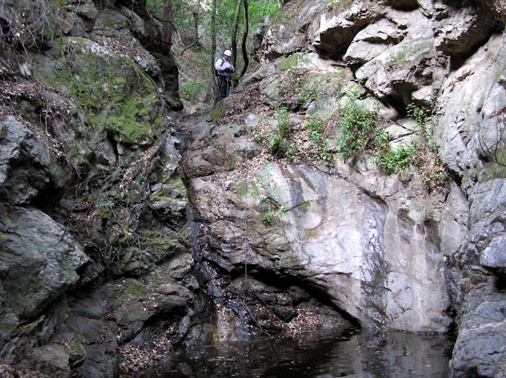
Another 30min of easy travel follows before you arrive at a substantial drop-off at 2550ft and 1hr 15min from the start. From the lip you can see that the canyon turns right and drops down toward the confluence with another major fork entering on the right. Ahead and to the right you can see the CCC ridge and the fire-road that runs along its ridge-top. The drop-off starts with a sloping 40ft incline that drops into a pothole that is immediately followed by a 30ft vertical drop into another pool. This double drop can be rappelled from a manzanita bush up on the right of the lip of the 40ft incline. Alternatively, this descent can be bypassed by means of a steep use-trail on the right that descends the ridge to a point just below the 30ft drop where you rejoin the canyon. Just around the corner is the third of the steps in this series, a 40ft vertical rappel from a bush up on the left down into a small, 3ft deep pool.
Downstream, there is a section of easy travel with occasional obstacles. Roughly 1hr 50min from the start at 2330ft there is a 30ft rappel from a bush on the left and a few minutes later a 20ft downclimb up and over the shoulder on the left. Twenty minutes later you come to a series of pools that end with a sloping 20ft rappel from a root on the left that deposits you in the first chest-deep pool. This is followed by a long easy section with many small pools.
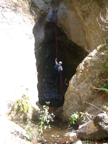
|
|---|
| Grotto and pothole |
(Photo by Ken King) |
The action quickens about 3hrs 15min from the start at 2040ft beginning with a small 8ft downclimb past a large log propped up against the lip and then a 12ft drop into a neat little grotto which is most easily rappeled on the left. This is immediately followed by two small downclimbs around deep pools, the first on the left and the second on the right, both using bushes and ledges. Then 3hrs from the start at 1980ft you arrive at the series of rappels that constitute the final descent into the Arroyo Seco. The first is an awkward 15ft drop into a deep pool for which the only viable anchor is a bush high on the left. This is immediately followed by a chimney downclimb into another 5ft deep pool. The next step is the most interesting, a 35ft overhanging rappel down a narrow slot into a moss-covered and cliff-ringed grotto. The anchor is a large tree on the left but watch for the bee hive here. The rappel deposits you into a pothole that is fortunately only a couple of feet deep. A simple 15ft sloping rappel from a tree on the right follows before you arrive at the last rappel, a 20ft drop from a large log propped up against the lip. This drops into a pool at the side of the Arroyo Seco. You should arrive at this confluence with the Arroyo Seco at 34o14.96'N 118o10.70'W and an elevation of 1930ft about 4hrs 45min from the morning start having travelled about 1.4mi in that time.
Cross the Arroyo Seco to find the well-travelled trail up on the southern slope of the canyon; turn right for the easy hike downstream to the Oakwilde Picnic Area. You should get to Oakwilde at 34o14.74'N 118o11.03'W and an elevation of 1810ft about 5hrs 15min from the morning start having travelled about 2.1mi. The picnic tables in the sun make a good place to dry out and have lunch.
Some care is needed to locate the start of the steep Twin Canyon trail
that you will follow up to the Angeles Crest Highway. From Oakwilde
start up the marked Dark Canyon trail (Dark Canyon meets the Arroyo Seco at
Oakwilde). Just after you leave the picnic area and about 100yds
past the restrooms, the trail crosses the Dark Canyon stream.
Immediately after the crossing, make a sharp left turn leaving
the Dark Canyon Trail to follow the unmarked Twin Canyon trail. This
trail climbs very steeply at first. The grade eases as you reach the ridgetop
and pass under electrical pylons. It then becomes a fairly easy trail that
traverses along the side of Twin Canyon over to meet the Angeles Crest Highway
at the pullout where you left the return vehicle. You should reach this
pullout at
34o14.74'N 118o11.42'W
and an elevation of 2610ft after about 6hrs of hiking
having travelled about 2.7mi.
Last updated 2/10/07.
Christopher E. Brennen