ADVENTURE HIKES AND CANYONEERING
IN THE SAN GABRIELS
© Christopher Earls Brennen

|
|---|

|
Hike J4. Bonita Canyon
- Hiking time: 6 hours
- Estimated hiking distance: 2.2 miles
- Elevation gain: None
- USGS Topo Maps: Cucamonga Peak, Devore
- Difficulties: Four rappels ranging in height from 25ft to 160ft
- Special equipment: Rapelling equipment with one 200ft rope and a 200ft recovery line, 20ft of webbing, 2 rappel rings.
-
ACA Rating: 3A III

Characteristics
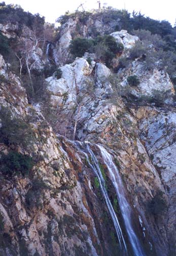
The eastern end of the San Gabriels is riven through by the three forks of Lytle Creek which have created some rugged and beautiful canyons in this section of the mountains. The South Fork of Lytle Creek runs due east from the slopes of Cucamonga Peak and forms the northern side of a dominant ridge, the San Sevaine ridge, that also runs east from Cucamonga and overlooks the eastern end of the San Gabriel Valley. The north slope of San Sevaine ridge that overlooks the South Fork is particularly precipitous. Bonita Canyon is one of many small tributaries of the South Fork that drain this north slope and drop dramatically as they do so. In particular, Bonita Creek falls through three spectacular waterfalls, respectively 190ft, 40ft and 160ft high, during the last phase of its descent into the South Fork. This hike accesses the top of Bonita Canyon and follows the stream through its entire course down to Lytle Creek. The highlight is the dramatic and challenging descent of three spectacular waterfalls, the Upper, Middle and Lower Bonita Falls. It is a dry hike suitable for any time of the year provided the streamflow is not unusually swollen.
Trailhead
This hike requires a four-wheel-drive shuttle. From Los Angeles take the 210 or 10 Freeway east toward San Bernadino and the 15 Freeway north toward Barstow. About 3mi before the intersection of the 15 and 215 Freeways in Devore, exit the freeway where the signs indicate the Lytle Creek recreation area. Drive north past Nealey's Corner toward Lytle Creek and, 1.6mi from the freeway, identify a left turn to a prominent white metal gate (34o12.10'N 117o26.92'W, elevation 2230ft). This is the entrance to the San Sevaine Flats road that you will shortly follow. Then continue on up the Lytle Creek road to the point where the South Fork joins the main Lytle Creek. We wish to identify a roadside parking area that overlooks this junction. It is 4.3mi north of the San Sevaine Flats road junction and 1.2mi beyond the Lytle Creek Ranger Station. It is also 0.14mi south of the road junction to the South Fork Campgrounds. Park one vehicle here (34o14.23'N 117o29.86'W, elevation 2910ft) and then drive back down Lytle Creek road to the gate to the San Sevaine Flats road.
It is possible to drive a 2WD vehicle up the rough dirt road that climbs up to San Sevaine Flats but it is not recommended; a 4WD vehicle is much preferred. It takes about 40min to drive the 7.5mi to the road junction where the access road to the radio towers forks to the right. Turn right onto that spur road and proceed about 200yds to a saddle almost in the shadows of the radio towers. Park in a small turnout on the right (34o12.71'N 117o30.15'W, elevation 5520ft).
Hike
From the 5520ft saddle near the radio towers (34o12.71'N 117o30.15'W), proceed into the obvious shallow valley that leads north from the saddle. The going is easy, open low forest and the canyon slowly deepens into an open gully relatively free of brush or brambles. It is a pretty, isolated canyon rarely visited by humans. The faint use trail that can be detected in places is an animal track; bear traces are evident. About 1hr from the start you pass the junction (elevation 4400ft) with the first substantial tributary entering on the right. The going remains straightforward with benches on either side occurring with increasing frequency until, 3hr from the start at about 3850ft, you arrive at the top of the first significant obstacle, a multiple stage waterfall descending about 60ft in total. This can be readily downclimbed on the right using some trees and footholds to access a shallow gully that leads down to a broad sloping bench on the right side.
 | 
| |
|---|---|---|
| Upper Bonita Falls | Lower Bonita Falls with Upper in background |
A short distance further downstream you arrive at the second falls, a rappel of about 25ft using a convenient tree anchor on the left. Descend into a large shallow pool and continue the rappel down the second small step to the base of the waterfall. It is possible to bypass these falls high on the right but the footholds are sketchy and the rappel is much safer. Another easy and gently descending section of canyon follows with increasing bushes on either or both sides of the stream.
|
|---|
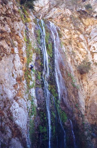
| Author descends Lower Bonita Falls |
Then, quite suddenly, you arrive (4hr from the start at 3360ft) at the top of a high waterfall with a panoramic view of the precipitous final section of Bonita Canyon and the surrounding mountains. There is a pathway to the right of the top of the falls leading to a flat clearing or platform with an even more spectacular view. Far below is the broad boulder field that is the South Fork of Lytle Creek. And all around is a convoluted mosaic of cliffs and trees and waterfalls. Cliffs surround three sides of the platform and the exposure is awesome. Others have clearly gathered here and camped to enjoy the marvellous view. The high waterfall whose top you passed and which lies immediately below and to the left is the first or uppermost of the three spectacular Bonita Falls. It falls about 200ft, crashing down a recessed gully with the water bouncing off the rock walls on both sides. It would be very difficult to rappel directly down this waterfall and so I recommend that you bypass it in the following way. On the right or innermost side of the platform is a steep, earthy gully that many have used to climb up to and down from the platform. The upper section of this gully can be either downclimbed or rappelled. The lower section is best rappelled using one of the larger trees in the gully. The neccesary rappel is only about 25ft high. From the bottom, continue to descend a steep earthy, rocky slope to rejoin the stream.
Before continuing downstream, I recommend that you hike a few yards upstream to the base of the aforementioned Upper Bonita Falls. This is a fine spot to pause, to enjoy this beautiful waterfall and to rest before the last and most difficult part of the hike. It is certainly one of the most beautiful waterfalls in all the San Gabriels.
Resuming the descent, the next immediate obstacle is the Middle Bonita Falls, a sloping cascade about 40ft high. Use the tree in the middle of the canyon as the anchor and rappel down to the base, a short flat area at the top of the final and most specatacular obstacle, the Lower Bonita Falls. This vertical drop of about 160ft, is an awesome sight when you stand near the lip and look down. There is no difficulty with the anchor for there are three robust young trees on the right that allow one to descend dryly to the right of the falls. Though the height is awesome, both the entry on the right and the descent are quite straightforward. You should reach the bottom about 5.5hr from the start.
From the bottom of Bonita Falls, a well-worn trail to the right
of the stream descends to the boulder
field (3100ft) which is the South Fork of the Lytle Creek, a short
10min hike. Turn right at the end of Bonita Canyon and
angle across the boulder field to the north or left side
of the flood plain where there is a trail travelling due east. The trail
proceeds along the south side of two campgrounds and then arrives at
Lytle Creek. Find a spot to cross the river; just a few yards through
the trees you climb the bank up to the road and, hopefully, the parked
vehicle
(34o14.23'N 117o29.86'W,
elevation 2910ft).
Last updated 1/17/03.
Christopher E. Brennen