ADVENTURE HIKES AND CANYONEERING
IN THE SAN GABRIELS
© Christopher Earls Brennen

|
|---|

|
Hike D13. Bailey Canyon
- Hiking time: 5 hours
- Estimated hiking distance: 3 miles
- Elevation gain: 1280 feet
- USGS Topo Maps: Mount Wilson
- Difficulties: About 12 rappels ranging in height from 25ft to 110ft, several with free rappel due to overhang.
- Special equipment: Full rappelling equipment with a 160ft rope, a 120ft rope, a 120ft recovery cord, 150ft of webbing, 12 rappel rings and, as insurance, a bolt setting kit.
-
ACA Rating: 3A III

Characteristics
Bailey Canyon is a rugged fissure in the San Gabriel mountains just north of Sierra Madre. Like many of the front range canyons it has seen some changes since it was first homesteaded by R.J.Bailey in 1875 and then sold in 1881 to Palmer T. Reed, a clerk at the Sierra Madre Villa Hotel. Later in the 1880s, foxes and coyotes were trapped in this canyon, their fur shipped to Chicago. Bailey remains home to an active group of coyotes whom you may spot in the early evening as you exit the canyon. The canyon property was later divided, portions being sold to the Sierra Madre Municipal Water Company, the Passionist Fathers (who built the monastery) and the Carter family. In the 1930s, the WPA built an amphitheater just above the current debris basin but extensive flooding in 1938 damaged the amphitheater and other structures in the area. In 1965 the Carter family donated the land for the City Park and the trail up to the Stone Cabin was known for years as the Carter Trail.
As canyons go Bailey Canyon is not particularly special, indeed it is a rather short canyon that does not penetrate much more than a mile into the San Gabriel foothills. But it is a steep and rugged place and provides an exhilerating adventure hike with some 12 rappels, one over 80ft high and several with free rappels due to overhang. The distances involved are short so it is truly a concentrated rappelling experience. This adventure is only for the experienced rappeler since it may require the setting of additional anchors in several places. In recent years bolts have been placed at all the major rappels. All of these should be backed up with other anchors but this is difficult to do in a couple of places; I encourage other canyoneers to use their inventiveness and not to place bolts unless these are absolutely neccessary.
As with all deep canyons, Bailey should be avoided during or shortly after rain. However, being short, the canyon drains fairly quickly and, even in winter, the stream is otherwise modest and long sections of the canyon are dry.
Trailhead
To reach the trailhead, drive north through Sierra Madre (on Baldwin or Michillinda) to the east/west street, Grandview. Then drive east from Michillinda or west from Baldwin and turn north onto Grove. Grove runs directly into the small Bailey Canyon parking lot (34o10.26'N 118o3.67'W and elevation 1120ft). Park here.
Hike
From the parking area (34o10.26'N 118o3.67'W and elevation 1120ft), walk WNW through the trees, go through a turnstile and proceed north on the closed asphalt road that skirts around the west side of Bailey Canyon debris basin. The asphalt changes to dirt as you enter the canyon and quickly becomes a trail. About 0.25mi from the parking area, the trail crosses the small stream for the first time and, immediately thereafter, it forks at about 34o10.57'N 118o3.68'W and elevation 1350ft. The left fork proceeds up the canyon bottom and you will come down this way on the return leg of the hike. However, our ascent follows the right fork that switchbacks up the right or east wall of the canyon to an elevation of about 2000ft and then contours north to drop into a lovely little glade perched in a pocket high above the cliffs and waterfalls of the lower canyon. Here, water almost always runs in the streambed, and has allowed a substantial grove of trees to flourish and fill the shadier depths of the pocket. Years ago, someone carried sufficient building materials up the steep trail to construct a small stone cabin. Now, only low stone walls remain to serve as a bench or table at this delightful picnic venue. You should reach this rest stop at 34o11.10'N 118o3.55'W and an elevation of 2400ft about 1hr 20min from the start. Here you harness up and prepare for a rugged and exciting descent down Bailey Canyon.
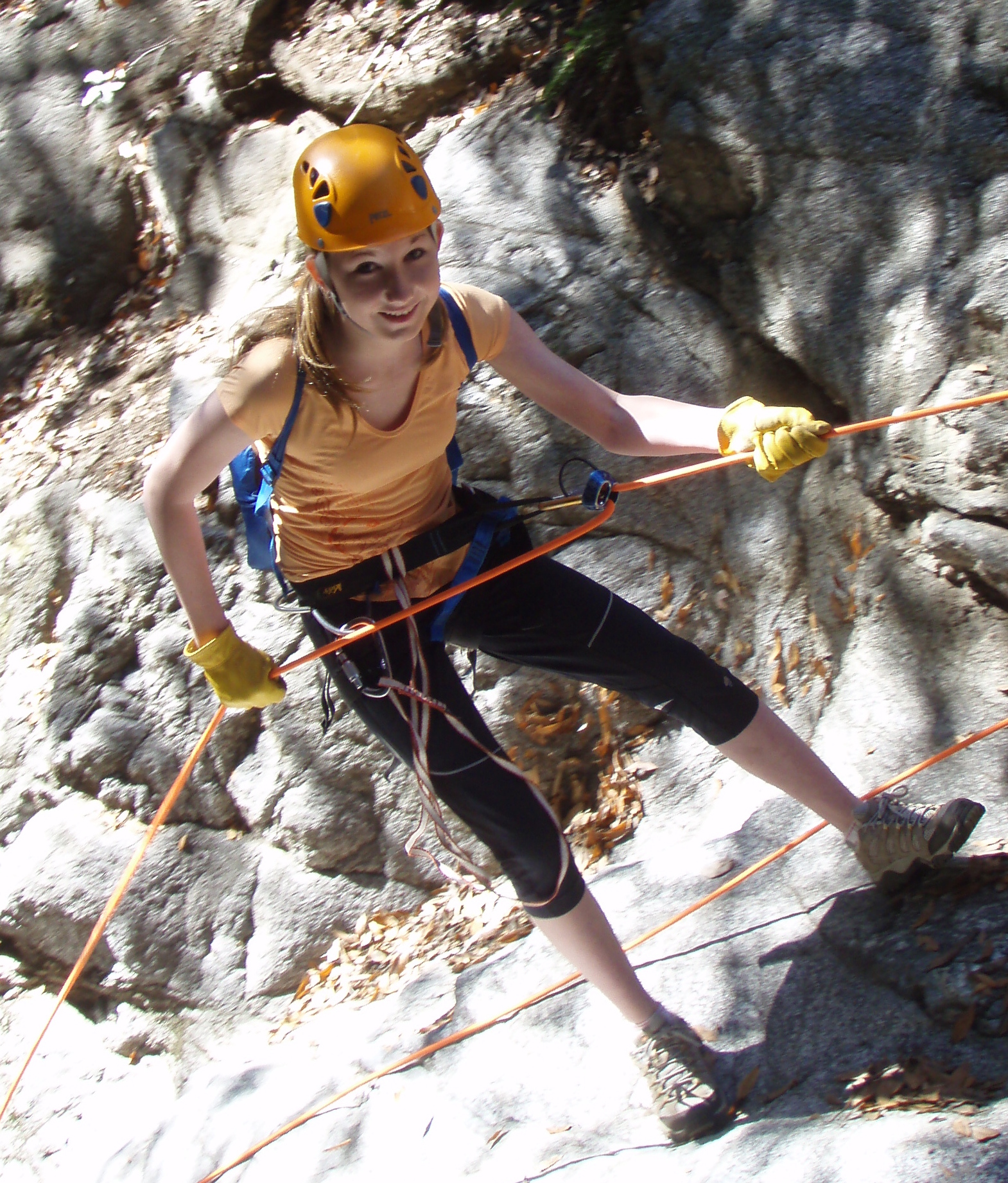 | 
| |
|---|---|---|
| Starting the 110ft rappel | Entering the free rappel |
The descent begins immediately behind the stone cabin and there are a few small falls before the first, substantial and vertical 30ft waterfall that you will reach about 10min into the descent. No rappel is needed here; simply climb up the dirt slope on the left to the large tree and then descend the steep dirt slope to the bottom of the falls. Many convenient tree roots help control the descent. This is followed a short distance downstream by a small 12ft waterfall that is simpler than it first appears; just free climb down the left center. The only reason for mentioning it is that, just downstream on the right wall of the canyon, is a horizontal mine shaft about 4ft in diameter. You can crawl about 100ft to the end of this shaft if you wish.
Continuing on down the shady canyon, you will reach the first rappel about 40min below the stone cabin at an elevation of 2240ft. This is the first of five in a row within a horizontal distance of not much more than 100yds. The first is a modest 25ft drop with an excellent anchor in the form of a large tree about 10ft up the dirt slope on the right. Here you must rappel down through abundant weeds. The second follows immediately and is much higher, dropping about 40ft. There is a single bolt anchor on the left side of the lip that should be backed up with webbing to one of the nearby stout bushes. You may get a little wet here rappeling down the middle since water falls most of the year.
A very short section will bring you to a simple 15ft downclimb that you should reach about 1hr from the stone cabin. Below this the canyon narrows and the walls steepen to form a dramatic slot whose airy end can be seen directly ahead. A short distance into this slot there is a 25ft rappel down an inclined ledge to the right of a narrow and wet slot with a small pool at the bottom. This is anchored by a single bolt in the right wall but could be backed up with webbing to pitons on the left of the streamcourse.
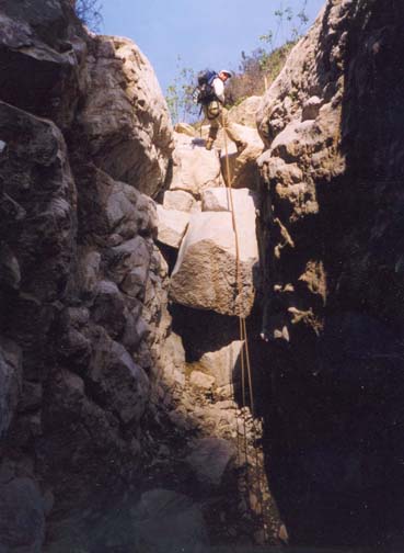
Just a few yards beyond the small pool the slot opens up and there is a dramatic 110ft drop known as Slide Falls where the canyon makes an abrupt left turn. The main problem here is finding a sufficient number of secure anchor points for this long rappel. There is a good single bolt on the left side and some old pins on the right that provide some backup if a long section of webbing is deployed. The descent of Slide Falls is long but easy, down a broad sloping rock face. We reached this point (elevation 1900ft) about 1.5hrs from the stone cabin.
About 30yds beyond the base of Slide Falls is the last of five in this dense series. It is a small, 25ft dryfall known as Stairstep Falls that you can anchor using either one of the large rocks a short distance upstream of the lip or the big tree above the right side (it is tricky to get a rope around this tree). The canyon here has clearly been subjected to recent rockfalls and other catastrophic events and the bottom is rougher going than elsewhere. However it is more open here than either above or below. It is possible to access this stretch from the trail high overhead using the steep gully on the left just below Stairstep Falls.
The series of five rappels described above is not separated from the next by more than a few hundred yards of canyon so I am not certain why I draw a line there, except perhaps to identify even more clearly the next few descents that are the jewels at the heart of Bailey Canyon. Walking along this flat and relatively open section it is a surprise to arrive at a point where the bottom suddenly drops about 50ft into a deep and narrow rock-ribbed gorge. This is known as Overhang Falls; three good bolts in a large rock at the top provide a good anchor for this exciting rappel. As you descend the first 25ft is over large boulders but the bottom 25ft is a free rappel because of the overhang created by those boulders. About 20yds beyond Overhang Falls is a small 20ft drop that can be free-climbed perhaps with a belay for those who need it.
Another 100yds or so will bring you to another attractive 50ft rappel down a sloping slot of solid rock, known as Needle Falls (years ago a large boulder was jammed in the slot creating a passage known as the Eye of the Needle and hence the name). Clearly Needle Falls has been the scene of much rock climbing for there are the remains of many bolts in the rock over the entire height of the slot. There is currently one good bolt at the left side of the lip but finding a backup is difficult here. The entry and the 50ft rappel are straightforward. However, at the bottom the canyon immediately turns right and falls another 20ft down a steep slot. It is possible to free climb down this slot but there is a single bolt in the right wall to use for a rappel or a belay.
The last essential rappel is just about 30yds below the slot and consists of a drop caused by a huge, canyon-filling boulder. The anchor here is a single bolt in the right wall just above the slot between the huge boulder and the canyon wall; there are nearby boulders that could be used for backup on this 20ft rappel.
An often overgrown section of canyon follows this last essential rappel and along this stretch there are a number of small waterfalls to negotiate. After several hundred yards, you arrive at another 30ft drop formed by a very similar canyon-filling boulder. While you may choose to rappel down this one also using a single bolt installed in the top of the boulder, it is also possible to scramble about 10ft up the rock of the canyon wall on the left. If you do so you will find that this leads to a small trail that descends about 20yds and takes you downstream of the waterfall. However, the trail ends at a small tree where you need to climb down about 12ft to the canyon bottom. The climb is much aided by the roots of the tree, by a piece of webbing wrapped around the tree and by a number of good footholds.
Almost immediately you encounter the last large waterfall in Bailey Canyon, a wet 35ft known as First Falls that I often avoid. It is easier to negotiate the rough trail around the right side of the falls and, to do so, you should climb the rough dirt slope on the right of the canyon just upstream of the lip. This leads to a ridge and you will see the rough trail down a steep slope in the canyon corner that leads to a narrow trail on a ledge that, in turn, provides an easy descent to the canyon bottom. However, if you choose to rappel this last waterfall, there is a single bolt installed on the left side of the lip.
You are now in that part of Bailey Canyon
that is often frequented by casual hikers and the return to the carpark
(34o10.26'N 118o3.67'W and
elevation 1120ft)
takes only about 20min. The rest of the hike is a straightforward
though the trail is still rough in places; on the way you pass the fork
where, earlier in the day, you left the canyon bottom to switchback
up the canyon wall.
Since you may pass this way late in the day, you
stand a good chance of spotting one of the coyotes who make Bailey
Canyon their home.
Last updated 1/1/05.
Christopher E. Brennen