ADVENTURE HIKES AND CANYONEERING
IN THE SAN GABRIELS
© Christopher Earls Brennen

|
|---|

|
Hike G2. Allison Mine Loop
- Hiking time: 8.5 hours
- Estimated hiking distance: 8.3 miles
- Elevation gain: 2070 feet
- USGS Topo Maps: Mount San Antonio, Mt.Baldy, Glendora, Crystal Lake
- Difficulties: Three rappels of 40ft, 30ft and 80ft, some downclimbing and some difficult route finding
- Special equipment: Rappelling equipment with 200ft rope, 30ft webbing, 3 rappel rings, headlamp
-
ACA Rating: 3A III

Characteristics
High in a dramatic scar on the precipitous south face of Iron Mountain is a mine whose proprietors risked life and limb almost daily in an effort to get rich. They built several airy trails to access their mine and this hike follows one of them on the way to the mine. Those daredevil miners were the experienced prospector, John James Allison and his three sons. The Allison mine was worked intermittently from 1915 until about 1942. It is located high up in Allison Gulch, a tributary of the East Fork of the San Gabriel river (the junction is a short distance upstream of a notable feature of the East Fork canyon called ``Swan Rock''). There are two alternate routes to the mine, each with their own challenges.
Having reached the mine by one of these two routes, this adventure descends Allison Gulch. Just below the mine you enter a spectacular, vertical gorge whose descent requires three or four rappels including a 80ft drop down the last waterfall. Though not as big as some of the other gorges in the San Gabriels Allison Gulch is one of the prettiest. After the rappels you continue down Allison Gulch to the East Fork of the San Gabriel and return to the East Fork Trailhead.
This adventure hike can be done in a day though you should start early in order to have a little time to explore the mine. Obviously you may choose either of the routes to the mine and any of the three on the return.
 | 
| |
|---|---|---|
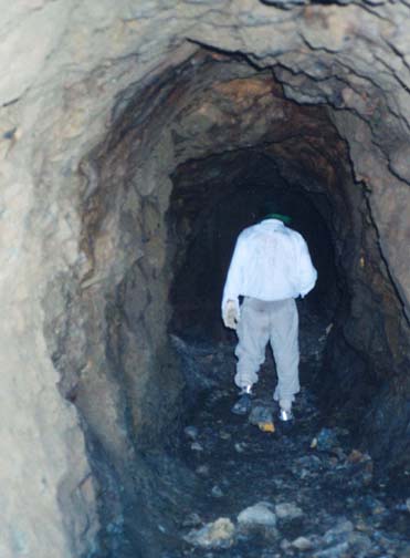
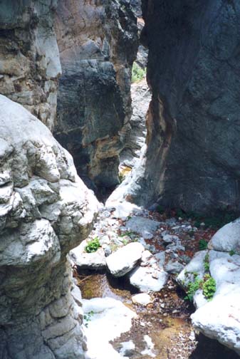
| In the Allison Mine | Allison Gulch above the rappels |
Trailhead
The trailhead for this hike is the parking area at the end of the East Fork road (34o14.21'N 117o45.92'W, elevation 2030ft). Drive up Highway 39 from Azusa to a point north of Morris and San Gabriel dams where there is a highway junction. Turn right across the bridge following the signs to the East Fork. The trailhead is about 6mi up this road just past the junction with the Glendora Mountain Road and the bridge over Cattle Canyon.
Hike
There are two possible routes on the way to Allison Mine and each has its challenges. The preferred route which is described first proceeds up Allison Gulch from the East Fork; it involves a substantial navigational challenge in which an altimeter is almost essential for success. The alternate "ridge route" along the Heaton Flats Trail is easier but longer and involves considerable bushwhacking.
Begin the adventure by walking around the locked gate just beyond the East Fork trailhead parking area (34o14.21'N 117o45.92'W, elevation 2030ft). It is 0.5mi north along the dirt road up the East Fork to the small campground at Heaton Flats (34o14.48'N 117o45.68'W, elevation 2050ft). The alternate "ridge route" splits off here to climb the right wall of the canyon but we proceed up the East Fork trail that crosses the river many times (there are usually trails on both banks). These crossings can be quite dangerous in the winter when the river is running full but in summer are usually less than knee deep. It is, however, almost impossible to keep your feet dry even in late summer. The 2.7mi hike to the junction of the East Fork and Allison Gulch follows a pretty, wooded canyon bottom with many nice pools in which to swim. It is a popular place for gold panners.
The first challenge is to accurately identify the junction with Allison Gulch (34o15.77'N 117o44.79'W, elevation 2410ft). This occurs about 200yds beyond Swan Rock, a large cliff on the left side of the East Fork where there is an intrusion of white rock in the shape of a giant swan. At Swan Rock the East Fork makes a sharp right turn and about 200yds further it turns sharp left. Allison Gulch forks off to the right at this left turn. It is a large tributary and easy to find. You should reach this point, 2.75mi from the start about 1hr 20min after starting out. If you have an altimeter, take note of its reading at this point.
There is no trail up Allison Gulch, but is is a heavily wooded glen with little brush and therefore fairly easy going as you climb up the rocky streambed. There is usually some water flowing though it goes underground in places. Hike up the Gulch for about 0.75mi until you reach an altitude of 3060ft where you will encounter a gully entering on the left (34o16.01'N 117o44.18'W, elevation 3060ft). It is critical that you locate the correct gully. The altitude is the primary identifier but there are others. The gully you want occurs where the main stream makes a sharp right turn. The gully entrance is well-defined and brush free. There is a sustantial tree and a notable vertical wall, both on the left at the gully entrance. A large log with an unusual longitudinal crack also lies across the left side near the gully entrance though it will probably rot away soon. You should reach this point about 2hr 20min after the morning start having covered 3.5mi.
Note your altitude here for further navigational challenges lie ahead. Then climb up the bed of the relatively brush-free gully for another 550ft of elevation gain, to an altitude of about 3600ft. At that point watch for a fork in the gully with the main branch going left and a steep, scree-filled fork going right. Do not take either fork. Instead transition onto the steep slope on the right where you should find an array of faint, braided trails that switchback up the slope between the bushes. Climb another 3-400ft up this slope veering somewhat to the right. Near the top, as you approach a shoulder off to the right, you should, with a little luck, find a faint trail that begins to contour around to the right at 34o16.19'N 117o43.99'W and an elevation of 3970ft. Follow that trail. In places you have to negotiate a series of yuccas that block the way. But soon you should see the remains of the mine structures on the other side of the canyon. Finally, the trail makes a 100ft steep descent into the woods beside Allison Gulch; it emerges onto a flat area where the mine buildings once stood. You should reach the mine (34o16.28'N 117o43.71'W, elevation 4110ft) about 4hr 15min and 4.2mi from the start of the hike.
Alternate Route to Mine:
The alternate route to the mine is very brushy but easier to navigate than the route described above. As in the first route you follow the East Fork dirt road along to Heaton Flats (34o14.48'N 117o45.68'W, elevation 2050ft). There you leave the road and take the Heaton Flats trail (8W16) that forks to the right and climbs the side of the canyon. This is a well-maintained trail but one that can be hot and hard work in the summer season. For that reason this hike is best attempted in the cooler months. At an elevation of about 2750ft the trail reaches a saddle that allows a good view down into Cattle Canyon. At this saddle turn left and continue along the trail that soon reaches the crest of a long ridge that runs all the way to the slopes of Iron Mountain. From the ridge the 8007ft high Iron Mountain looks deceptively close. In fact, it is a very hard (and waterless) two day hike to reach this summit and return (see Iron Mountain hike).
However, the current objective is more modest. The trail rises and falls as it follows the ridge until, 3.4mi from Heaton Flats, the trail descends about 100ft to a prominent saddle at 34o15.53'N 117o43.38'W and an elevation of 4580ft. This is a good rest stop and an important place to identify correctly. Apart from the incoming trail, three other trails emanate from this saddle. One reasonably good trail descends from the saddle to the right or east and goes to the Widman Ranch in Coldwater Canyon, a tributary of Cattle Canyon. Part of the ranch can be seen from the saddle. The trail to the summit of Iron Mountain proceeds directly up the steep incline at the other side of the saddle. The most indistinct and overgrown of the three trails is that which leads to the Allison Mine. This turns left (west) at the saddle and contours along the south face of the ridge that projects to the west and separates Laurel Gulch (directly below the saddle) from Allison Gulch (to the north on the other side of the ridge). A number of yuccas provide awkward obstacles on the first stretch of this trail. Further along you are often pushing through the brush while watching the ground to determine the direction of the trail. Finally you reach the west end of the ridge and the trail contours around to the north side high above Allison Gulch. The brush is particularly thick just before the point where you turn from the spine of the ridge onto the east running trail on the north slope. However, as soon as you make this turn, the vegetation abruptly changes to pine forest and the going is much easier. From the ledges cut into the rock and the occasional rock buttressing, you will recognize that you are travelling on the remnants of the original trail built by the Allisons.
 | 
| |
|---|---|---|
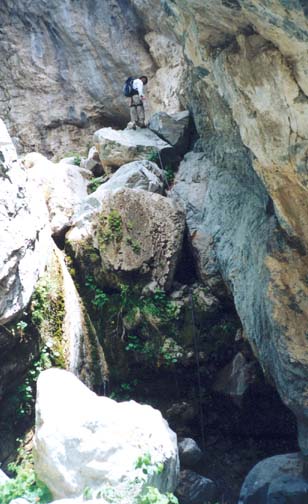
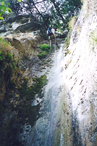
| First rappel in Allison Gulch | Big rappel in Allison Gulch |
Soon after the turn, stop to survey the dramatic scenery and the topology of the rest of the hike. On the other side of the canyon, you will readily make out the large scar that Allison Creek has cut into the side of Iron Mountain. At the bottom of this gulch, where the creek seems to reach the floor of the canyon below, you should be able to spot a very beautiful, thin waterfall. This is the last rappel during the descent of the Gulch. With your eyes (or binoculars) follow the gulch up above the waterfall and you will conclude that there are a series of obstacles above that waterfall. Look a little further up and you may be able to discern some of the remains of the Allison Mine in a wooded area just to the right of the gulch. This alternate route contours around the head of Allison Gulch to these remains. The going is relatively easy on the north-facing stretches but, as you get close to the mine, there are several south-facing sections on which the brush is very heavy indeed. On the last stretch before reaching the mine, look out for the trails on the opposite wall of the steep canyon. The preferred route described above follows one of these trails. Finally you reach the readily recognizable remains of the mine some 3mi from the saddle at 34o16.28'N 117o43.71'W and an elevation of 4110ft.
The Allison Mine:
The remains of the Allison Mine are quite extensive. Many horizontal shafts penetrate the steep hillside above the trail to the east of the stream and are best seen from the trail on the west side. Just above the stream on the east side, you encounter the remains of a large wooden tip behind which is a large mine opening to an array of horizontal and vertical shafts. These shafts can safely be explored for a short distance but you need a good flashlight. Also, if you follow the trail down to the right of the wooden tip and then follow a short trail around to the right you will encounter another horizontal shaft that is easy to explore.
The Descent:
When ready to begin the return journey just follow the rocky streambed as it descends steeply. About 15min from the mine you encounter the first substantial obstacle, a pretty 15ft waterfall covered in green moss. There is a tricky 15ft downclimb from a shelf on the left side. If you wish to rappel instead, there is a convenient anchor tree just above the shelf. Below this downclimb you enter the most spectacular part of the Allison Gulch, a narrow gorge with towering grey walls that first bend left, then right and then left again. The streambed falls steeply through this defile. You can downclimb for a short distance but soon encounter the first rappel about 45min after leaving the mine at an elevation of 3760ft. This consists of a 40ft drop that is best anchored by a webbing wrap around a large boulder on the left. Several more downclimbs follow but very soon you come to the second rappel, a 30ft vertical waterfall where it is difficult to avoid getting wet. The anchor is a huge rock sitting in the middle of the stream just upstream of the lip; it had a large variety of rope and webbing wraps around it when we passed this way.
Downstream of this second rappel, the gorge broadens and becomes less dramatic. You might expect no further rappels. But quite suddenly, about 1hr 50min after leaving the mine and at an elevation of 3500ft, you come to the top of a dramatic 80ft vertical waterfall that drops into a three-sided rock cavity cut into the rock by eons of flowing water. There is a large tree with a huge branch across the canyon just upstream of the lip and this provides an excellent anchor. It is difficult to avoid getting wet during the descent and there is a small, thigh-deep pool at the bottom. Once at the bottom you can stow the rope and harnesses.
From the bottom of this last rappel, it takes about 30min
of scrambling and bouldering to reach the entrance to the gully that
you followed on the ascent
(34o16.01'N 117o44.18'W,
elevation 3060ft). And from that junction it takes another
35min to descend to the East Fork
(34o15.77'N 117o44.79'W,
elevation 2410ft). You should reach the East
Fork just under 3hrs after leaving the mine.
The remainder of the hike down to the East Fork trailhead
(34o14.21'N 117o45.92'W,
elevation 2030ft)
follows the trail described in the East Fork Transit hike. This last stretch
takes about 1hr 15min; the return trip from the mine
covers about 4.1mi in 4hr 15min.
Last updated 28/5/02.
Christopher E. Brennen